Absheron Peninsula
| Abşeron Yarımadası | |
|---|---|
 | |
| Motto: Qara qızıl diyarı (The land of the black gold) | |
| Seat | Baku city |
| Subdivisions | |
| Area | |
| • Total | 2,110 km2 (810 sq mi) |
| Population (December 2008) | |
| • Total | 3.4 million |
| • Rank | 1st |
| • Density | 3,070/km2 (8,000/sq mi) |
| Ethnicity | |
| • Azerbaijani | 96% |
| • Other | 4% |
| ISO 3166 code | AZ-AB |
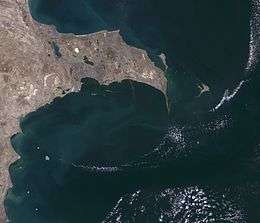
The Absheron Peninsula (Azerbaijani: Abşeron yarımadası) is a peninsula in Azerbaijan. It is host to Baku, the biggest and the most populous city of the country, and also the Baku metropolitan area, with its satellite cities Sumgayit and Khyrdalan.
There are three districts, of which two are urban (Baku and Sumgayit), and one (Absheron Rayon), is suburban district in Absheron region.
It extends 60 km (37 mi) eastward into the Caspian Sea, and reaches a maximum width of 30 km (19 mi). Though technically the easternmost extension of the Caucasus Mountains, the landscape is only mildly hilly, a gently undulating plain that ends in a long spit of sand dunes known as Shah Dili, and now declared the Absheron National Park. In this part the peninsula is dissected by ravines and characterized by frequent salt lakes.
Etymology
The etymology is as follows: The word Absheron consists of a few parts. Ab means water, shour means salty and an is the suffix that makes plural in Persian. So, Abshouran, which came out these words, means "place of salty water". This is also the name of a city in Russia which is called Apsheronsk.
According to Conrad Malte-Brun in 1810, an alternative name for the peninsula was Okoressa. [1]
Geography
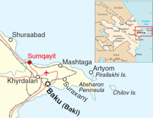
The Absheron Peninsula is nearly the metropolitan area of Baku because the Baku metropolitan area consists of Baku city, Sumgayit and Khyrdalan whereas the Absheron Peninsula consists of Baku city, Sumgayit and Absheron rayon whose center is Khyrdalan.
Climate
The Absheron Peninsula, has a temperate semi-arid climate (Köppen climate classification: BSk) with warm and dry summers, cool and occasionally wet winters, and strong winds all year long. The peninsula is the most arid part of Azerbaijan (precipitation here is around or less than 200 mm (8 in) a year). The majority of the light annual precipitation occurs in seasons other than summer, but none of these seasons are particularly wet. The natural vegetation of the Absheron Peninsula is dry steppe and semi-desert. Due to the semi-arid climate, local agriculture requires irrigation.
Economy
Beginning in the 1870s, the Absheron Peninsula was the site of some of the world's earliest petroleum production. Much of the landscape remains scarred with rusting oil derricks. Despite serious problems with environmental damage and pollution, the Absheron is known for its flowers, horticulture, mulberries and figs. The northern coast has wide though less-than-pristine beaches which are popular local tourist attractions.
Wealthy people have settled in the Absheron Peninsula, including Robert Nobel and Zeynalabdin Taghiyev.
References
External links
- Geography of Azerbaijan
- History of Absheron
- Short Documentary about pollution from chemical and oil industries on the peninsula
Coordinates: 40°27′49.20″N 49°57′27.29″E / 40.4636667°N 49.9575806°E