April 17–19, 1970 tornado outbreak sequence
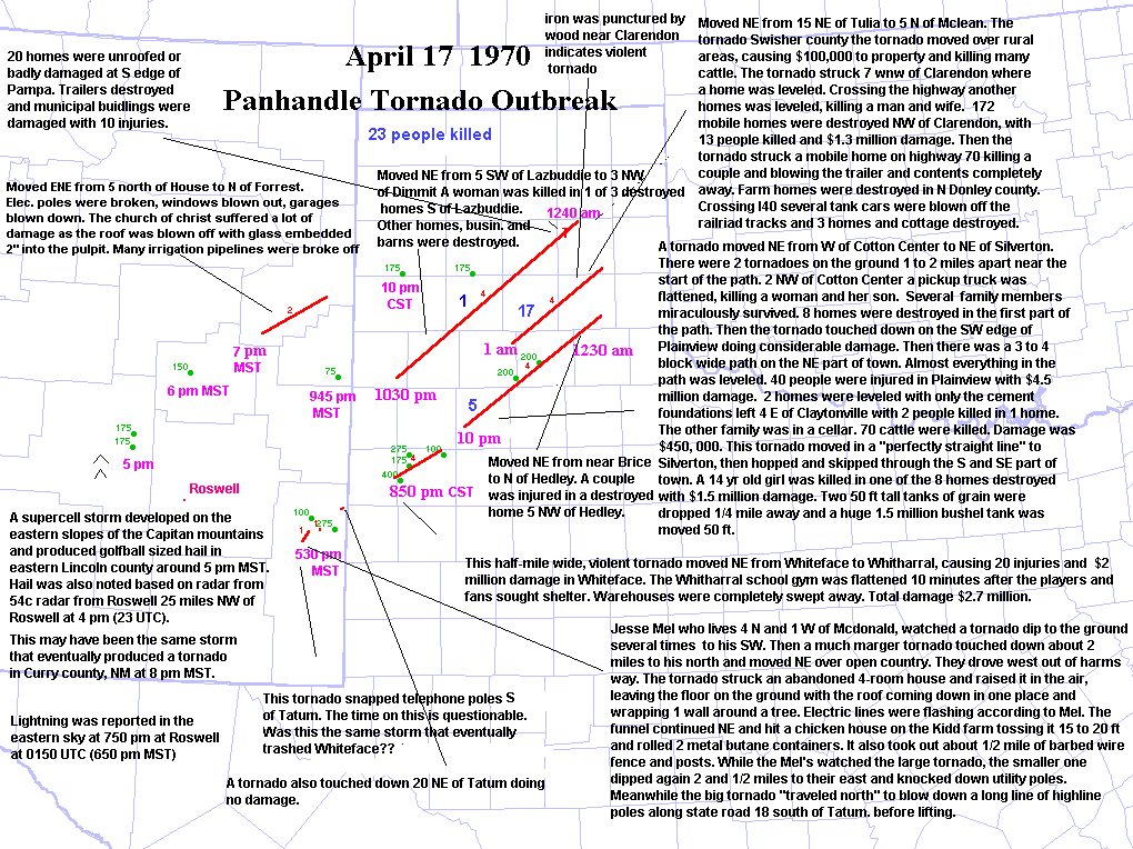
The April 17–19, 1970 tornado outbreak sequence was a tornado outbreak sequence[nb 1][nb 2] that occurred on April 17–19, 1970, across parts of the Midwest and South. An outbreak on April 17 produced many strong tornadoes, including four violent and long-lived tornadoes, in New Mexico, western Texas, and the Texas Panhandle. More tornadoes hit East Texas and Oklahoma on April 18, and additional tornadoes affected the Mississippi Valley and Midwest regions on April 19. At least 33 tornadoes occurred, 17 of which were F2 or greater (significant) in intensity.[2][3] In addition to confirmed tornadoes, a possible F2 tornado hit the southern suburbs of Pampa, Texas, at 12:40 a.m. CST on April 18, unroofing or severely damaging 20 homes, destroying several trailers, and damaging municipal buildings.[4]
Tornado table
Confirmed tornadoes by Fujita rating
| F0 |
F1 |
F2 |
F3 |
F4 |
F5 |
Total |
| 4 |
12 |
10 |
2 |
5 |
0 |
33 |
Confirmed tornadoes
April 17
| List of confirmed tornadoes - April 17, 1970 |
|---|
| F# | Location | County | Time (UTC) | Path length | Damage |
| New Mexico |
| F1 |
W of McDonald |
Lea |
0030 |
7.1 miles (11.4 km) |
Utilities and chicken coops were damaged in a skipping tornado that "dipped and rose twice."[5] |
| F1 |
S of Tatum |
Lea |
0030 |
0.1 miles (0.16 km) |
An abandoned house and chicken coops were damaged. 2.5 miles (4.0 km) of power poles were downed.[5] |
| F2 |
N of House to S of San Jon |
Quay |
0200 |
39.8 miles (64.1 km) |
A tornado passed through McAlister, north of Forrest, and near Glenrio, Grady, and Ragland. Numerous farm buildings, windmills, outhouses, fences, granaries, utility poles, and a television antenna were damaged.[5] The roofs and windows of two churches also sustained damage. Glass was found embedded .5 inches (1.3 cm) in the pulpit and pews.[5] Total losses reached $53,000. This tornado is not listed as significant by tornado researcher Thomas P. Grazulis.[6] |
| Texas |
| F4 |
Whiteface to W of Anton |
Cochran, Hockley |
0250 |
30 miles (48 km) |
A violent tornado, .5 miles (805 m) wide, caused $20,000,000 in damage and 20 injuries as it passed through Whiteface.[6] Most of the injuries occurred in trailers, but five were in a school auditorium.[6] A school gymnasium in Whitharral was destroyed minutes after spectators and players had left.[6] Several large warehouses in Whiteface were leveled and had their concrete block foundations swept clean.[4] The tornado was said to have resembled a "rain cloud" and a "'ball of fire'."[5] |
| F4 |
NE of Cotton Center to SW of Hedley |
Hale, Floyd, Swisher, Briscoe, Hall, Donley |
0400 |
96.6 miles (155.5 km) |
5 deaths – A long-tracked tornado family first damaged rural areas between Cotton Center and Hale Center, where two tornadoes were reported to have been on the ground simultaneously. Four to five funnel clouds were observed in the area, and a continuous damage path extended 20 mi (32 km) long.[5] Two people died as their pickup truck was "'smashed flat as a pancake'," and eight homes nearby were destroyed, with seven injuries and $750,000 damage reported.[5] The tornado caused $4.5 million in damage as it passed through Plainview, first appearing aloft over storm observers on the southwest edge of town, then skipping east as it downed trees and power lines, destroying some buildings.[5] Turning to the northeast, the tornado badly damaged taller structures and produced an intermittent path 400–600 yards (366–549 m) wide through Plainview. The tornado then touched down continuously as it hit Seth Ward, leveling everything in a three-to-six-block-wide swath. Two rural homes east of Claytonville were leveled, one of which had only its concrete block foundation left.[6] Near Claytonville, a continuous path 20 mi (32 km) long and 300–400 yards (274–366 m) wide was reported.[5] Damages there reached $445,000, and 70 cattle were killed or injured. In Silverton, the tornado killed a 14-year-old girl and destroyed eight homes.[4] Damages reached $1.5 million, half of which was to a large grain elevator. Two tanks 50 feet (15 m) tall were carried for .25 mi (0.40 km), and a bushel tank weighing 1,500,000 pounds (680,389 kg) was moved 50 feet (17 yd).[4] The last damage occurred near Hedley as a farmhouse and barns were destroyed.[4] |
| F4 |
Lazbuddie to SE of White Deer |
Parmer, Randall, Armstrong, Carson, Gray |
0430 |
130 miles (210 km) |
1 death – A violent tornado first struck the Lazbuddie community, destroying three farmhouses and killing a woman.[5] Three other homes were damaged, as were many barns and businesses.[4] The tornado produced a continuous path 26 mi (42 km) long before lifting and possibly reforming as a new tornado.[5] The tornado touched down again for 20 mi (32 km) from near Happy to south of Canyon. Other damage was reported in another touchdown near Conway.[5] |
| Sources: NCDC Storm Events Database, Grazulis 1993 |
April 18
| List of confirmed tornadoes - April 18, 1970 |
|---|
| F# | Location | County | Time (UTC) | Path length | Damage |
| Texas |
| F4 |
W of Vigo Park to W of McLean |
Swisher, Briscoe, Armstrong, Donley, Gray |
0700 |
65 miles (105 km) |
16 deaths – The final long-tracked tornado of the night touched down northeast of Tulia, causing $100,000 damage to ranches and farms.[4] The tornado leveled two homes on each side of U.S. Route 287, west-northwest of Clarendon, killing a man and injuring his wife.[4] Next, the tornado struck the Sherwood Shores community on the Greenbelt Reservoir, destroying about 172 mobile homes, killing 13 people, and injuring 35 others.[4] Nearby, two more people died in another mobile home,[5] and several farmhouses were damaged in Donley County.[4] Near I-40, railroad tank cars were blown off railroad tracks, one of which landed on the interstate.[4] Three farmhouses and a cottage were destroyed near McLean, and several other cottages were damaged before the tornado lifted.[4] |
| F2 |
Near Lake Worth |
Tarrant |
2100 |
2 miles (3.2 km) |
A tornado struck the Roy Rogers marina on Lake Worth, destroying one houseboat and badly damaging two other boats. The houseboat was picked up and moved 50 feet (17 yd).[5] The tornado is not listed as significant by Grazulis.[4] |
| F2 |
N of Cross Mountain |
Bexar |
0030 |
0.5 miles (0.80 km) |
Two homes were unroofed, trees were uprooted, and power lines were downed. A pumphouse was thrown 100 yards (91 m).[5] The tornado is not listed as significant by Grazulis.[7] |
| F1 |
NE of Plano |
Collin |
0330 |
1 mile (1.6 km) |
A brief tornado threw a vehicle into a fence, injuring two high school students inside the vehicle.[5] |
| F2 |
Royse City |
Rockwall |
0400 |
0.1 miles (0.16 km) |
A tornado destroyed a "large mobile home," unroofed a dairy store, and damaged one home.[5] The tornado is not listed as significant by Grazulis.[7] |
| F0 |
N of Franklin |
Robertson |
0420 |
0.8 miles (1.3 km) |
Only minor damage was reported.[5] |
| New Mexico |
| F0 |
NE of Tatum |
Lea County, New Mexico |
2200 |
0.1 miles (0.16 km) |
No damage reported.[5] |
| Oklahoma |
| F2 |
SW of Ada |
Pontotoc |
2210 |
5.2 miles (8.4 km) |
A tornado destroyed a barn and damaged a home.[4] |
| F0 |
W of Wainwright |
McIntosh |
0015 |
0.5 miles (0.80 km) |
Brief tornado.[5] |
| Sources: NCDC Storm Events Database, Grazulis 1993 |
April 19
| List of confirmed tornadoes - April 19, 1970 |
|---|
| F# | Location | County | Time (UTC) | Path length | Damage |
| Texas |
| F2 |
E of Longview |
Gregg |
0655 |
1.2 miles (1.9 km) |
At a nursing home, a tornado twisted a porch, resulting in roof damage. Numerous large trees were twisted off and in some cases were thrown into homes.[5] The tornado is not listed as significant by Grazulis.[7] |
| Louisiana |
| F3 |
SW of Elm Grove to S of Taylortown |
Caddo, Bossier |
1000 |
6.8 miles (10.9 km) |
A tornado produced a discontinuous path from Wallace Lake to near Taylortown. A mobile home was turned onto its side, and a home, tenant homes, barns, and tractor sheds sustained damage.[5] The tornado is not listed as significant by Grazulis.[7] |
| Tennessee |
| F2 |
SW of Cordova |
Shelby |
1645 |
0.3 miles (0.48 km) |
A brief tornado struck a golf course and a clubhouse, unroofing a large storehouse and dropping steel trusses onto the clubhouse.[5] The tornado hit north of Germantown. It is not listed as significant by Grazulis.[7] |
| Mississippi |
| F4 |
W of Ripley to Corinth to N of Counce, TN |
Tippah, Alcorn, Hardin (TN) |
1806 |
47.6 miles (76.6 km) |
4 deaths – A probable tornado family produced an intermittent damage path for 40 mi (64 km) across northern Mississippi. In and near Ripley, several homes sustained roof damage, windows were broken, a trailer was blown off its foundation, a barn was destroyed, and trees were uprooted.[5] A school auditorium roof was lifted and displaced slightly. Losses in Ripley reached $50,000. The tornado may have lifted and reformed into a new tornado before touching down for 3 mi (4.8 km) on the south side of Corinth.[5] The main damage was concentrated in three segments 200–250 yards (183–229 m) wide, with roof and tree damage between each segment. Three churches were destroyed, numerous homes were wrecked, and several gas leaks were reported.[5] In all, the tornado destroyed 69 homes and damaged 149 at Corinth,[5] where losses reached $1.8 million and all four deaths occurred, two of which were in a church[7] that was unroofed.[5] Across the Mississippi–Tennessee state line in Hardin County, Tennessee, a house, a mobile home, two farm buildings, and a garage sustained severe damage. Damage at Counce reached $30,000.[5] |
| Utah |
| F1 |
Annabella |
Sevier |
2100 |
1.5 miles (2.4 km) |
A brief tornado damaged two trailers and carried a woman 30 feet (10 yd). The woman sustained minor injuries to her head.[5] |
| Arkansas |
| F2 |
SW of Harrisburg |
Poinsett |
2215 |
1.3 miles (2.1 km) |
A church was partly unroofed and shifted on its foundation. Six trailers were severely damaged, and downed trees damaged carports, porches, and roofs.[5] The tornado is not listed as significant by Grazulis.[7] |
| F3 |
Greasy Corner |
St. Francis |
2215 |
1.8 miles (2.9 km) |
A small tornado touched down north of Hughes, destroying a small farmhouse and injuring two occupants. Nearby homes and other structures sustained damage.[7] The tornado is listed as an F2 by Grazulis.[7] |
| Illinois |
| F1 |
SE of Thebes |
Alexander |
2250 |
0.1 miles (0.16 km) |
One unoccupied mobile home was overturned and another mobile home was shifted 1.5 feet (0.5 yd) on its foundation. Roofs were damaged and windows broken in the Olive Branch area.[5] |
| Missouri |
| F0 |
SE of East Prairie |
Mississippi |
2300 |
0.2 miles (0.32 km) |
A tornado touched down at several points in the Big Oak Tree State Park, snapping trees 2.5–3.5 feet (0.8–1 m) in diameter and damaging the forest canopy.[5] |
| F1 |
Miner |
Scott |
2330 |
0.2 miles (0.32 km) |
A dozen trailers sustained damage in a brief touchdown.[5] |
| Florida |
| F1 |
Destin |
Okaloosa |
0045 |
0.1 miles (0.16 km) |
A small building was blown off its foundation, a boat was overturned, and there was other minor damage.[5][8] |
| Georgia |
| F2 |
W of Cataula |
Harris |
0200 |
0.5 miles (0.80 km) |
One home was destroyed and another damaged.[7] |
| Indiana |
| F1 |
Bloomfield |
Greene |
0230 |
0.8 miles (1.3 km) |
|
| F1 |
SW of Bloomfield |
Greene |
0230 |
0.8 miles (1.3 km) |
|
| F1 |
NE of Harrodsburg |
Monroe |
0245 |
0.1 miles (0.16 km) |
A brief tornado caused $100,000 damage to boats and a dock.[5] |
| F2 |
SW of Bloomington |
Monroe |
0245 |
5.6 miles (9.0 km) |
A "small" tornado struck Highland Village near Bloomington, moving one home 75 feet (25 yd), damaging several homes, overturning trailers, and damaging five planes at the county airport.[7] |
| F1 |
S of Versailles |
Ripley |
0300 |
3.3 miles (5.3 km) |
A three-car garage and three farm buildings were destroyed.[5] |
| F1 |
N of New Elizabethtown to NW of Hayden |
Jackson, Jennings |
0345 |
12.8 miles (20.6 km) |
Farm buildings were damaged.[5] |
| Sources: NCDC Storm Events Database, Grazulis 1993 |
See also
Notes
- ↑ An outbreak is generally defined as a group of at least six tornadoes (the number sometimes varies slightly according to local climatology) with no more than a six-hour gap between individual tornadoes. An outbreak sequence, prior to (after) modern records that began in 1950, is defined as, at most, two (one) consecutive days without at least one significant (F2 or stronger) tornado.[1]
- ↑ All damage totals are in 1970 United States dollars unless otherwise noted.
References
Bibliography
- Grazulis, Thomas (1993), Significant Tornadoes 1680-1991: A Chronology and Analysis of Events, St. Johnsbury, Vermont: Environmental Films, ISBN 1-879362-03-1
- Grazulis, Thomas (2003), The Tornado: Nature’s Ultimate Windstorm, Norman, Oklahoma: University of Oklahoma Press, ISBN 978-0-8061-3538-0