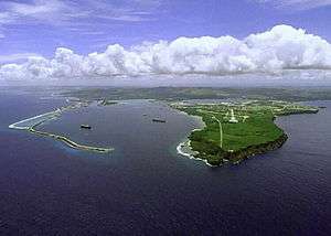
Apra Harbor
_enters_Apra_Harbor_for_a_scheduled_port_visit.jpg)
Apra Harbor is a deep-water port on the western side of the United States territory of Guam. The harbor is formed by Orote Peninsula in the south and Cabras Island in the north. To the south, the harbor narrows and then widens again to form an inner harbor. The southern end of the harbor is the location of Naval Base Guam. The northern end is the commercial port, which handles about 2 million tons of cargo a year. It is considered one of the best natural ports in the Pacific and attracts many tourists.
Past and future use
Apra comes from the Chamorro word apapa 'low.' Apapa is the original name for what is now Cabras Island. During Spanish rule, a saint’s name was added and the area became known as the port of San Luis de Apra.
Since 1898, ships that burned coal, and later petroleum products, used Guam's ports, mainly Apra. From 1941 to 1944 during World War II Apra Harbor was under Japanese control and was fully used for repair and refueling of their submarines and warships. The liberation of Guam in 1944 caused huge amounts of damage to the coastal environment. Navy News noted that over 7,000 tons of explosives had been used that previous year to clear ship passages in Guam. 50 pounds (23 kg) of these explosives is enough to destroy a volume of coral 100 by 3 feet (30.48 m × 0.91 m) deep. The Glass Breakwater and inner Apra Harbor were built to support the US military after World War II. Apra Harbor served military, civilian shipping needs, and included facilities for ships and nuclear submarines. Also for repair, supply, and fuel transfer. Nuclear and conventional weapon transfer; fishing, recreational, and tourist also used the harbor.
Apra Harbor was home to rich fishing grounds. It took the ports of Umatic and Central Hagatna's place during the 19th century when the ports of Piti and Sumay opened which was put into more frequent use. Piti was the main port for Hagatna while Summay was used for a rest stop for whalers. As many as 60 whaling ships came through the harbor per year. While Hagatna was the capital of Guam, Summay became the commercial and financial part of town.
During the whaling period, Apra was considered to be one of the best ports in the Pacific. As the whaling era came to an end Guam's economy was in decline. Guam's economy started to improve when Spain's reign came to an end.
U.S. naval Captain Henry Glass claimed Guam as part of the U.S. on June 20, 1898. Guam connected with the rest of the world in 1903 when it became the site of telegraph cable stations.
Today most of Apra Harbor is controlled by the U.S. Navy, but some ports remain public such as Sasa Bay, the Piti Channel and parts of Glass Breakwater. The land where the commercial port was located was transferred to Guam's government in 1969.
Apra Harbor today is more than an important port to Guam. It is also a popular recreation area for personal watercraft user, boaters, and surfers. Apra Harbor is home to a couple shipwrecks that are popular with scuba divers. The most well known wrecks are the World War I-era German merchant ship, SMS Cormoran, and the World War II-era Japanese freighter, Tokai Maru which lie side by side on the ocean floor.
Military realignment and the expansion of Apra Harbor
In 2006 the U.S. Japan "Roadmap for Realignment Implementation Agreement" agreed that over 8,600 U.S. Marines currently based in Okinawa, Japan would relocate to the U.S. territory of Guam and the Marianas Islands. This reorientation could be one of the largest peacetime military relocations in U.S. history. The details of the military move are evolving, and much is on hold due to budget sequestration. The U.S. Navy has suggested the need for expansion of Apra Harbor, which is the largest deep water port in the Western Pacific and the busiest in Micronesia to allow the basing of additional ships in Guam as part of the Navy's shift to the Pacific.
Coordinates: 13°27′12″N 144°39′12.56″E / 13.45333°N 144.6534889°E