Apple Orchard Mountain
| Apple Orchard Mountain | |
|---|---|
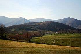 Apple Orchard Mountain in the top center with the distinctive FAA Radome on the summit. | |
| Highest point | |
| Elevation | 4,224 ft (1,287 m) [1] |
| Prominence | 2,835 ft (864 m) [1] |
| Coordinates | 37°31′01″N 79°30′37″W / 37.51694°N 79.51028°WCoordinates: 37°31′01″N 79°30′37″W / 37.51694°N 79.51028°W [2] |
| Geography | |
 Apple Orchard Mountain Bedford / Botetourt counties, Virginia, U.S. | |
| Parent range | Blue Ridge Mountains |
| Topo map | USGS Arnold Valley |
| Climbing | |
| Easiest route | Hike |
Apple Orchard Mountain is a peak of the Blue Ridge Mountains in Virginia.
Located in Jefferson National Forest, Apple Orchard Mountain is the county highpoint for both Bedford County and Botetourt County, Virginia as well as the highest point on the Blue Ridge Parkway in Virginia. It is also the most topographically prominent mountain in the state.[1] The summit is open, and an FAA radar stands nearby. This radar stand makes the mountain recognizable from miles away.
References
- 1 2 3 "Apple Orchard Mountain, Virginia". Peakbagger.com. Retrieved Feb 20, 2010.
- ↑ "Apple Orchard Mountain". Geographic Names Information System. United States Geological Survey. Retrieved March 29, 2013.
This article is issued from Wikipedia - version of the 5/24/2015. The text is available under the Creative Commons Attribution/Share Alike but additional terms may apply for the media files.