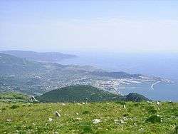
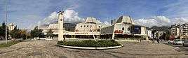
Bar, Montenegro
| Bar Бар | |||
|---|---|---|---|
 | |||
| |||
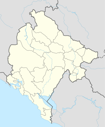 Bar Location of Bar, Montenegro | |||
| Coordinates: 42°06′N 19°06′E / 42.10°N 19.10°ECoordinates: 42°06′N 19°06′E / 42.10°N 19.10°E | |||
| Country | Montenegro | ||
| Founded |
6th century as Antipargal (assumed) | ||
| Settlements | 83 | ||
| Government | |||
| • Mayor | Zoran Srzentić (DPS) | ||
| Area | |||
| • Total | 598 km2 (231 sq mi) | ||
| Population (2011 census) | |||
| • Total | 17,727 | ||
| • Density | 67.0/km2 (174/sq mi) | ||
| • Municipality | 42,068 | ||
| Demonym(s) | Barani | ||
| Time zone | CET (UTC+1) | ||
| • Summer (DST) | CEST (UTC+2) | ||
| Postal code | 85000 | ||
| Area code | +382 30 | ||
| ISO 3166-2 code | ME-02 | ||
| Car plates | BR | ||
| Climate | Csa | ||
| Website | http://www.bar.me/ | ||
Bar (Montenegrin Cyrillic: Бар, pronounced [bâr], Italian: Antivari, Albanian: Tivar) is a coastal town and seaport in southern Montenegro. It is the capital of the Bar Municipality and a center for tourism. In 2011, its population was 40,037.
Name
Bar is a shortened form of Antivari, which is derived from the town's location across the Adriatic Sea from Bari, Italy.[1] Variations are in Italian, Antivari / Antibari; in Turkish, Bar; Albanian: Tivari; Greek: Θηβάριον, Thivárion, Αντιβάριον, Antivárion; in Latin, Antibarium.
History
Ancient times
Local archaeological findings date to the Neolithic era. It is assumed that Bar was mentioned as the reconstructed Roman castle, Antipargal, in the 6th century. The name Antibarium was quoted for the first time in the 10th century.
Middle Ages
In the 6th and 7th centuries, Slavs occupied the Balkans. Duklja, a Slavic, or Serbian state, was mentioned in the 10th century. Jovan Vladimir (ruler 1000 – 1016), of Skadarska Krajina is the first ruler of Duklja whose history is known. Stefan Vojislav (ruler 1018 – 1043), the eponymous founder of the Vojislavljević dynasty, defeated the Byzantines in a battle on a hill near Bar. He made Bar his seat of power. Vojislav then expanded the area under his rule. Mihailo I of Duklja (ruler 1050 – 1081), Vojislav's son, established the Archdiocese of Antivari. He continued to fight the Byzantines in order to secure the town's independence. This led to a union of states known as the Serbian Grand Principality. From 1101 to 1166, the principality was ruled by the Vukanović dynasty. However, for much of this time, Bar was under Byzantine rule. In 1183, Stefan Nemanja conquered Bar and it stayed under Serbian control under the Nemanjić dynasty.
Venetian and Ottoman period
From 1443 to 1571, the region was ruled by the Venice. Bar (called Antivari by the Venetians, was part of the Albania Veneta. It was a city state with its own coat of arms, flag, statute and mint. In 1571, the Ottomans captured Bar and held the town until 1878. The archdiocese was preserved. One of the archbishops during this period was Andrija Zmajević. The Ottomans ceded Bar to Montenegro at the Treaty of Berlin.
Modern era
Guglielmo Marconi, the Italian scientist and pioneer in wireless telegraphy, made a radio connection between Bar and Bari on 30 August 1904. In 1908, the first railroad in this part of the Balkans was put into operation. During World War I, on 16 August 1914, the Austro-Hungarian navy's light cruiser SMS Zenta and an accompanying destroyer became trapped off Bar by a very large French fleet (over twelve battleships) and in the subsequent battle of Antivari the Zenta was sunk with considerable loss of life. The destroyer escaped.
In World War II, on 13 July 1941, an uprising against the Italian occupying forces in Bar took place. In 1945, about 2,000 Albanians were killed in Bar by Yugoslav Communist Partisans. Bar was largely destroyed in World War II and rebuilt into a modern city.
In 1979, there was an earthquake that devastated Bar. It has since been rebuilt.[2]
Geography
Location
Bar is located on the coastal western border of Montenegro on the shore of the Adriatic Sea. It is approximately 53 kilometres (33 mi) from Podgorica, the capital of Montenegro.To the east is the largest lake in the Balkans, Lake Skadar. To the west, across the sea, is Italy.[3]
Climate
Bar has a wind blowing from the south about 88 days a year, mostly during the winter. The southern wind is very soft and warm but raises the waves in the sea. The temperature is as in July – about 28 °C (82 °F). There are approximately 2160 sunny hours a year. In winter the temperature drops down to 10 °C (50 °F). In the Köppen climate classification, Bar has a mediterranean climate (Csa) close to a humid subtropical climate (Cfa). There is only one summer month with less than 40 millimetres (1.6 in) precipitation.[4] Winters are cool and rainy, with an average high of 12.3 °C (54.1 °F) in January and a low of 4.3 °C (39.7 °F). Snow is very rare occurrence in Bar, it usually snows once in a few years. The highest recorded snowfall occurred during January 2000, when 9 centimetres (3.5 in) was measured. Summers are generally warmer, drier and sunnier than the winter months. During summer, the highest temperatures are around 27 to 28 °C (81 to 82 °F) and the lowest 18 °C (64 °F). Precipitation is low during the summer months, although rainfall can still occur, with July averaging 4.5 days with measurable precipitation. Spring and fall are transitional seasons that feature mild weather that can often be wet and unpredictable. There are, on average, 2523 hours of sunshine per year, ranging from a low of 111.6 hours in December to a high of 350.3 hours in July.[5]
| Climate data for Bar, Montenegro | |||||||||||||
|---|---|---|---|---|---|---|---|---|---|---|---|---|---|
| Month | Jan | Feb | Mar | Apr | May | Jun | Jul | Aug | Sep | Oct | Nov | Dec | Year |
| Average high °C (°F) | 12.3 (54.1) |
13.0 (55.4) |
15.0 (59) |
18.0 (64.4) |
22.1 (71.8) |
25.3 (77.5) |
27.8 (82) |
27.7 (81.9) |
25.1 (77.2) |
21.6 (70.9) |
17.2 (63) |
13.6 (56.5) |
19.9 (67.8) |
| Average low °C (°F) | 4.3 (39.7) |
5.1 (41.2) |
6.8 (44.2) |
9.3 (48.7) |
13.1 (55.6) |
16.4 (61.5) |
18.4 (65.1) |
18.2 (64.8) |
15.8 (60.4) |
12.5 (54.5) |
9.1 (48.4) |
5.7 (42.3) |
11.2 (52.2) |
| Average precipitation mm (inches) | 156 (6.14) |
148 (5.83) |
130 (5.12) |
126 (4.96) |
86 (3.39) |
56 (2.2) |
37 (1.46) |
53 (2.09) |
107 (4.21) |
140 (5.51) |
182 (7.17) |
170 (6.69) |
1,391 (54.77) |
| Average precipitation days (≥ 0.1 mm) | 12.5 | 12.7 | 12.1 | 11.6 | 8.7 | 7.4 | 4.5 | 4.8 | 6.5 | 9.5 | 13.7 | 13.9 | 117.9 |
| Mean monthly sunshine hours | 120.9 | 124.3 | 170.5 | 198.0 | 260.4 | 297.0 | 350.3 | 316.2 | 249.0 | 198.4 | 126.0 | 111.6 | 2,522.6 |
| Source: Hydrological and Meteorological Service of Montenegro[5] | |||||||||||||
Flora and fauna
The coastal part of Bar supports maquis shrubland with oak, holm oak, laurel, myrtle, Spanish broom, oleander, hawthorn, sloe, thorn, butcher’s broom and asparagus. To the north and the mountains, there are oak and beech forests. Citrus fruits including tangerine, orange and lemon grow in the Bar area as do pomegranates, olives, grapevines and figs. Ginkgo biloba grows in the park of King Nikola’s palace.
Skadar Lake is rich in bird life including the pelican. Game animals are found in Ostros, Rumija, Lisinj, Sutorman and Sozina and include rabbit, badger, fox, wolf and boar. At the Bar sea shore one finds various kinds of shells, snails, echinodermata, cephalopoda and crayfish.
Governance
Demographics
Bar is the administrative centre of Bar Municipality, which includes the town of Sutomore and other small coastal towns. A census in 2011 recorded 42,048 people in the Bar Municipality. Bar city had 17,727 inhabitants.[6] Bar's population has been growing from 6,742 in 1981, to 10,971 in 1991, 13,719 in 2003 and 17,727 in 2011.
Divisions and settlements
The municipality of Bar is divided into 12 communes (mjesna zajednica), consisting of 83 settlements:
| Commune | Settlements |
|---|---|
| Bar I | central business district |
| Bar II | Polje, Burtaisi, Čeluga, part of Rene; |
| Bar III | part of Bjeliša, Sokolana, Stara Ambulanta, Zgrade Prvoborca; |
| Bar IV | Popovići, part of Bjeliša, Ahmetov Brijeg, Vuletića Brijeg, part of Rene and Trsanj |
| Bar V | Sustaš, Zupci, Marovići, Tuđemili |
| Šušanj | Zukotrlica, Novi Pristan, Zeleni Pojas, Ilino, Šušanj, Carevići, Vitići and Paladini |
| Sutomore | Brca, Zelen, Obala Željezničke Kolonije, Mirošica I, Turke, Pobrđe, Gorelac, Miljevci, Sozina, Zankovići, Suvi Potok, Mirošica II, Zgrade, Bjelila, Papani, Haj-Nehaj, Zagrađe, Mišići, Đurmani and Čanj |
| Stari Bar (Old Bar) | Stari Bar, Baukovo, Belveder, Velembusi, Gretva, Brbot, Turčini, Menke, Mikulići, Podgrad, Bartula, Rap, Gornja Poda and Donja Poda, Tomba, Gornje Zaljevo and Donje Zaljevo |
| Mrko(je)vići | Pečurice, Dobra Voda, Grdovići, Pelinkovići, Dabezići, Velje Selo, Kunje, Velja Gorana and Mala Gorana |
| Krajina | Arbneš, Veliki Ostros, Mali Ostros, Martići, Runji, Kostanjica, Bobovište, Ckla, Tejani |
| Šestan | Livari, Gornja i Donja Briska, Gornji Murići, Donji Murići, Besa, Pinčići, Bapsulj, Šestan |
| Crmnica | Virpazar, Orahovo, Bračeni, Mikovići, Zabes, Boljevići, Sotonići, Bukovik, Mačuge, Dupilo, Popratnica, Komarno, Trnovo, Gornji Brčeli, Donji Brčeli, Brijege, Ovtočići, Tomići, Utrg, Godinje, Seoča, Krnjice, Limljani, Gluhi Do |
Ethnicity
Ethnic composition of the municipality in 2011:
| Ethnicity | Number | Percentage |
|---|---|---|
| Montenegrins | 19,553 | 46.5% |
| Serbs | 10,656 | 25.34% |
| Muslims | 3,236 | 7.7% |
| Albanians | 2,515 | 5.98% |
| Bosniaks | 2,153 | 5.12% |
| Croats | 254 | 0.59% |
| Romani | 203 | 0.48% |
| Other | 318 | 0.76% |
| not declared | 2,097 | 4.99% |
| Total | 42,048 | 4.99% |
Religion
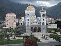
The main religion in Bar is Orthodox Christianity. However, there are churches from both the Christian Orthodox and Catholic traditions as well as mosques built by Ottomans in the Islamic tradition. Bar is the birthplace of Saint Jovan Vladimir. In 1089, the Roman Catholic Archdiocese of Bar, was founded and included most of Montenegro and Serbia.
| Religion | Number | Percentage |
|---|---|---|
| Eastern Orthodox | 24,902 | 58.15% |
| Islam | 15,472 | 30.14% |
| Roman Catholicism | 3,043 | 7.24% |
| Agnostic | 34 | 0.08% |
| Atheist | 415 | 0.99% |
| Other | 162 | 0.39% |
| Did not declare | 1,129 | 2.69% |
Places of worship
- St. George cathedral was built in the 12th century. Saint George was the mediaeval patron saint of Bar.
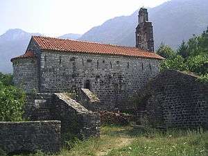
- The remains of the Bar Triconch' church lie in the center of Bar. It is the oldest Christian religious building in Montenegro, dating to the 6th century AD. It was built during Justinian's reign. The height of the preserved church walls is one metre. While carrying out research on the church, fragments of decorative stone moulds and a necropolis were found. It is where the Chronicle of the Priest of Duklja (Ljetopis popa Dukljanina) was written in the second half of the 12th century. It is the region’s most important medieval work of literature.
- Our Lady of Ratac (Bogorodica Ratačka) Benedictine monastery is located on the Ratac peninsula, between Bar and Sutomore. It was established in the 9th century AD.
- St. Tekla church was constructed in the 13th century from broken stone. At has been an Orthodox church, a Uniate church and then had another Catholic alter installed both of which remain. It is visited by people of both faiths and people of both faiths are buried in its cemetery.
- St. Roko church ruins are located near Sutomore. The church dates from the 14th century. Although the church had only one altar, it served both the Orthodox and Catholic faithful.
- St Atanasije church dates to the late 14th century. Around the church, there are several tombs covered with stone slabs.
- St. Petka church was built in the Middle Ages and is constructed of roughly hewn stone.
- St. Nikola church represents the Archbishopric of the City of Bar. In 1089, the archbishopric was founded and was confirmed by Pope Clement III when he sent the palij (mantle) to the Archbishop of Duklja. The archbishop was given the title Primas Serbiae.
- Ribnjak Monastery is located in the village of Zupci. Ruins of a church possibly founded by Jelena Anžujska (d‘Anjou) Nemanjić were found at the monastery. The monastery consists of a church dedicated to St. Vasilije Ostroški, a baptistry and accommodation building. The upper church, located above Ribnjak monastery, on Gradac hill is dedicated to the Holy Cross. It was constructed by two sirdars and a senator of the Principality of Montenegro between 1877 and 1878 after battles for liberation. King Nikola may have used the church as a base to plan his liberation operations. There is a long tradition of going to Ribnjak on 12 May each year, St. Vasilije Ostroški’s Day.
- Monastery of the Mother of God of Ratac is a Benadictine monastery dating to the 11th century AD. Its ruins are located on Cape of Ratac, between Bar and Sutomore. The ruins show three churches and several buildings protected by defence walls and towers. From 1443, the monastery was under Venetian authority. In 1571, it was burnt down by the Ottomans.
- Gornji Brčeli Monastery: The monastery is located in the village of Brčeli, which is named after the monastery. It was founded at the beginning of the 18th century by Bishop Danilo, as his winter residence. Within the monastery, there is the church dedicated to the Shroud of the Mother of God with an iconostasis, the handiwork of Petar Čolanović that dates from 1928. The monastery building and church are encompassed by a high stone wall with the main gate on the southern side. A one-sided belfry with a spinning-wheel mechanism was built on the wall beside the gate, on its eastern side. The old accommodation building was constructed as a typical house in Crmnica, with distinctive arched doorways and terraces. In 1863, a school was established within the monastery, which was later moved to the adjacent monastery of Donji Brčeli.
- Donji Brčeli Monastery is a 15th-century monastery located in Donji Brčeli. There is an associated church dedicated to St. Nikola where there is an arched room under the floor of the chapel. Its entrance is via the floor under the altar area. It is believed that this room was used as a dungeon during the reign of Šćepan Mali. Later, Šćepan Mali was murdered and buried in this church. The monastery also had a school.
- Omerbašića Mosque is located in Bar old town. It was constructed in 1662. Its structure is rather simple, with a rectangular base, and a minaret built next to the south-west wall. At the beginning of the 17th century, Dervish Hasan's domed burial site was built beside the mosque, at the entrance to the complex. A smaller ground level building was built next to it and was used as a residence. A public fountain was constructed near the entrance and later, a mosque house for a Muslim priest or imam was built as well. The whole complex is surrounded by a stone wall.
- Church of the Holy Mother, Gluhi Do village.
- St. Jovan, a two-nave church on the Virpazar-Bar road at Boljevići village.
- St. Mihailo, a two-nave church at the community cemetery in the village of Sotonići.
- Orahovo Monastery in Orahovo) village.
- St. Marija church near Bar old town.
- St. Marko church, 3 km (2 mi) north of Bar old town.
- Podgradska Mosque was built by several prominent citizens, among them Dervish Hasan Said. In 1881, in the explosion of Barutana, the mosque was demolished. A new mosque was built in the 1900s. The minaret was built in 1971, and refurbished in 1991.
Churches and monasteries dating to the era of the Balšić family (14th and 15th centuries) are located on the islands of Lake Skadar including Beška, Moračnik and Starčevo. This area is called the Holy Land of Montenegro.
- Starčevo Monastery is located on the island of Starčevo on Skadar Lake. It dates from the period of Đurđe Balšić. It was founded in 1377 by Father Makarije, who lived as an ascetic on the island. (Starčev means old man.) The monastery complex consists of the Church of the Assumption of the Mother of God, an accommodation building, supporting structures and a surrounding wall with a gate and several underpinned terraces. The monastery was a centre of literacy, where many manuscripts were rewritten and many books were bound and decorated. The crypt of Božidar Vuković of Podgorica, a printer, is located in this monastery. After the reconstruction of a part of the accommodation building, Starčevo became once again an inhabited and active monastery.
- Moračnik Monastery: It is located on the island of Moračnik on Skadar Lake. It was first mentioned in 1417, in the Charter of Balša III. The monastery complex consists of a church dedicated to the Holy Mother of God, an accommodation building, dining room and high tower with four floors, surrounded by a stone wall with a monumental gate.
- Beška Monastery: It is located in the middle of the island of Beška on Skadar Lake. The monastery consists of two churches: a larger one, dedicated to St. Đorđe (14th century), the endowment of Đurđe II Stracimirović-Balšić and a smaller one dedicated to the Holy Mother of God (1440), the endowment of Jelena Balšić. Beška Monastery, as well as Starčevo Monastery, was famous for its intensive transcription activities. The Gorička Anthology was written in this monastery. It is a religious, edifying transcript composed by Nikon Jerusalimac.
- Monastery of The Virgin of Krajina is a significant monument in Montenegro. Ruins of the monastery and church are dedicated to the Assumption of the Mother of God. The monument is located near Ostros, on the shores Lake Skadar. The church was first mentioned at the end of the 10th century in The Chronicle of Priest Dukljan. The monastery was founded by Duke Vladimir, well known from the legend about his tragic love with the beautiful Kosara, daughter of the Macedonian Tsar Samuilo. At one time, the monastery was the residence of the archbishop of Zeta. At the end of the 16th century, the monastery was completely destroyed. In its vicinity, in Ostros, there is a well from the year 1001, which is still used for supplying water to the inhabitants of local villages.
- St. Archangel church at Donja Seoca on the shore of Lake Skadar.
Economy
The economy of Bar relies upon the Port of Bar, the Belgrade - Bar railway and the Sozina tunnel. The Port of Bar is the most recognizable feature of the city. It occupies 3,100 m (10,170.60 ft) of seacoast, land area of 800 ha and aquatorium of 200ha. It is capable of reloading 5 million tons of goods annually. In 1976, the Belgrade – Bar railway was opened. It made the Adriatic coast accessible to tourists, and transport to the Port of Bar. The food company, Primorka has been operating in Bar for more than 50 years. It produces olive oil and pomegranate juice. There are 95,000 olive trees, about 80,000 citrus trees (lemon, orange, tangerine and grapefruit) in the municipal area. The centre for subtropical cultures, founded in 1937, is the oldest scientific institution in Montenegro. Tourism is also a major part of Bar's economy.
Transport
Bar has a ferry line to Bari, Italy which is operated by Montenegro Lines.[7] In season, ferries also go to Ancona, Italy. Bar is well connected with inland Montenegro, as well as with the rest of the Montenegrin coast. The Sozina tunnel, completed in 2006, shortened the road connection with Podgorica to around 50 km (31 mi). Bar is connected to other coastal towns by the Adriatic motorway, which extends from Ulcinj to Herceg Novi, and on to Croatia. Bar is also the final station of the Belgrade - Bar railway, which connects Bar with Podgorica, northern Montenegro and Serbia. Podgorica Airport is about 40 km (25 mi) from Bar. There are regular flights to Belgrade, Budapest, Zürich, Frankfurt, Ljubljana, Paris, Rome and Vienna.
Tourism
Although there are some nice stony beaches in Bar itself, many tourists choose destinations in other small towns in the Bar municipality, notably Sutomore, with its beautiful long sandy beach. The natural area around Bar is mostly untouched and is rich in vegetation. The Bar municipality stretches to the southern shore of Skadar lake and encompasses Krajina region. This entire area is suitable for leisure activities and hiking. Smaller settlements near Bar, such as Dobra Voda, Sutomore and Čanj, are a favourite destination for sunbathing, as they incorporate long sandy beaches.
Places of interest

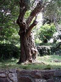
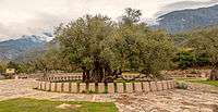
- The Old Olive of Mirovica is said to be one of the oldest olive trees in Europe and one of the oldest trees in the world. In 1957, it was placed under state protection. Numerous legends and traditions are associated with the tree. For instance, families that had a dispute would come to the tree to make peace. This explains its name, Mirovica, mir meaning peace.
- King Nikola’s palace was built in 1885. It was a present from King Nikola to his daughter Princess Zorka and his son-in-law, Prince Petar Karađorđević. The construction included a large palace, a little palace, a chapel, guardhouses and a winter garden. In 1910, a spacious ballroom was added. A botanic garden has Mediterranean vegetation including a cork tree. There is also a large flower garden in a stainless steel structure of interesting shape. it was a gift from King Emmanuel of Italy to King Nikola. It is now a restaurant called Knjaževa bašta (The Duke’s Garden). At the front of the palace, there was a wooden pier. Between 1866 and 1916, King Nikola owned ten yachts. One of them, Sibil, was bought from Jules Verne, the novelist. The last yacht bought was the Rumija. In 1915, it was sunk in the Bar harbour by the Austro-Hungarian navy. The palace complex houses the Bar city museum. It is also used as a venue for festivals, concerts, exhibitions and literary events.
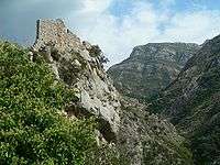
- Mount Rumija Fortress
- Nehaj Fortress, partially preserved, is located near the small seaside town of Sutomore. It has been held by both Venetians and Ottoman Turks. It was first recorded as the 16th century Fortezza dei Spizi, a Venetian fortified town.
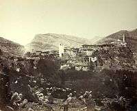
- Bar old town.
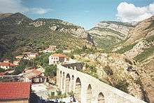
- The Bar Aqueduct was constructed during the 16th and 17th centuries.
Beaches
The Bar municipality has over 44 kilometres (27 miles) of sea coast. There are twenty beaches stretching over 9 kilometres (6 miles). In the north is Čanj, which has a 1,100-metre (3,600-foot) sandy beach. A boat takes tourists from Čanj to the Kraljičina Plaža. It lies below a natural wall of sedimentary rock. Further south is 300-metre-long (980-foot) Maljevik Beach. The beach at Sutomore, 1,200 metres (3,900 feet) long, has entertainments, activities and restaurants. Near the medieval monastery complex of Ratac is Crvena Plaža, named after the colour of its fine sand. The beach is surrounded by a pine forest and located about a hundred m from the main road to Bar. Just north of the Bar central business district is the 1,200-metre-long (3,900-foot)Žukotrlica Beach. It is a gravel beach, surrounded by a pine forest and varied Mediterranean vegetation. The Bar Gradska Plaža is located in front of King Nikola's palace. It is 750 metres (2,460 feet) long, part pebble and part sand. 10 kilometres (6 miles) south of central Bar is the 380-metre-long (1,250-foot) Veliki Pijesak. It is surrounded by numerous tourist facilities, restaurants and discothèques. On the border of the Bar and Ulcinj municipalities, in the village of Bušat, is the Val Maslina with its nearby olive groves. There are also beaches on the shore of Lake Skadar including the sandy Murici village beach and Pjesacac.
Culture
Sport

Bar has over fifty sports clubs, and associations including a chess club. There are numerous sports facilities in the Bar hotels and schools. In the centre of town, most of the facilities are in the Sports and Recreation Centre. Water sports such as diving are popular. Sports tourism is promoted because of the proximity to the sea and lake. Bar hosted the 2010 FIBA Europe Under-16 Championship and the 2010 Men's u18 European Handball Championship.
Festivals and events
- Summer with the stars is an annual musical festival held in July and August at King Nikola's Walk. The tourist organisation of Bar sponsors music concerts with singers from Montenegro and former Yugoslav republics.
- The Мotorcycle race of Sutomore is an annual race in early May and September.
- The International athletic meeting is held each May Day in Majarica.
- The Crmnica Games are held on weekends from mid-July to mid-August in Virpazar.
- An Agricultural show is held each year in early September in Virpazar to promote local produce.
- The Zagradje tourism show is held annually in July and August in Zagrade.
- The Lake Skadar Ecology, Tourism and Culture Day is held annually in July, in Murići.
- The Mrkojević family day is held in the last week of July, in Pečurice as a celebration of culture and traditions of the area.
- The Bar Guitar Fest is an annual gathering of guitar teachers and musicians held in January.
- The Olive Festival is held in Bar old town.
- The Wine and Bleak festival is held in December, in Virpazar.
- The Old Olive Tree Gathering has been held every November since 1987. It celebrates children’s works and works for children. Children are represented in literary and art works with the theme Olives, Peace and Friendship.
- The Port Cup is an international annual volleyball tournament for women which commenced in 1992.
- The Bar Marathon is a swimming race held in Bar in August. Contestants swim 5 kilometres (3.1 miles) between the Hotel Sozina, Sutomore and the Hotel Topolica, in Bar. The event commenced in 1988.
- The Chronicle of Bar is an annual summer multimedia festival with theatre plays, art exhibitions, literary events, and concerts and the Mediterranean Book Fair. It commenced in 1988.
- The International Television Festival' has been held each November since 1995 to celebrate the television arts.
International relations
Twin towns — sister cities
Bar is Twin towns and sister cities with:
See also
References
- ↑ Room A. Placenames of the World: Origins and Meanings of the Names for 6,600 Countries, Cities, Territories, Natural Features and Historic Sites. 2nd edition, 2005. ISBN 0786422483
- ↑ Guide to Places of the World. London: Reader's Digest Association Ltd. 1995. p. 73. ISBN 0-276-42213-9.
- ↑ Montenegro Google map accessed 23 October 2015.
- ↑ Peel, M. C. et al Updated world map of the Köppen–Geiger climate classification. Hydrol. Earth Syst. Sci. 2007, Volume 11(1027–5606) pp1633–1644 DOI 10.5194 Hess-11-1633-2007.
- 1 2 "Climatology". Hydrological and Meteorological Service of Montenegro. Retrieved November 13, 2012.
- ↑ "2011 Montenegrin Census" (PDF) (in English and Montenegrin). Monsta. Retrieved 12 July 2011.
- ↑ Bar-Bari Ferry Montenegro Lines.com
External links
| Wikivoyage has a travel guide for Bar. |
| Wikimedia Commons has media related to Bar, Montenegro. |
- Official site of Bar municipality (in Montenegrin)
- News site for Bar
- Tourist Organization of Bar
- Old Bar Fortress-City
- Bar Attractions