Antipodes Islands
 The Antipodes Islands seen from the north | |
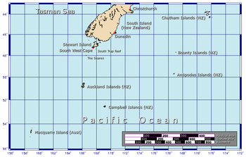 Position relative to New Zealand and other outlying islands | |
| Geography | |
|---|---|
| Location | 860 kilometres (534 mi) southeast of Stewart Island/Rakiura |
| Coordinates | 49°40′0.12″S 178°46′0″E / 49.6667000°S 178.76667°E |
| Archipelago | Antipodes Islands |
| Major islands | Antipodes Island, Bollons Island |
| Area | 22 km2 (8.5 sq mi) |
| Highest elevation | 366 m (1,201 ft) |
| Highest point | Mount Galloway |
| Administration | |
|
New Zealand | |
| Demographics | |
| Population | 0[1] (2006) |
| Additional information | |
| Nature reserve | |
The Antipodes Islands (from Greek αντίποδες - antipodes) are inhospitable volcanic islands in subantarctic waters to the south of — and territorially part of — New Zealand. They lie 860 kilometres (534 mi) to the southeast of Stewart Island/Rakiura.
The island group consists of one main island, Antipodes Island, of 20 km2 (7.7 sq mi) area, Bollons Island to the north, and numerous small islets and stacks.
Ecologically, the islands are part of the Antipodes Subantarctic Islands tundra ecoregion. The islands are inscribed on the UNESCO World Heritage List, together with other subantarctic New Zealand islands. The island group is a nature reserve and there is no general public access.
Etymology
The word antipodes derives from the Greek: ἀντίποδες,[2] plural of antipous (ἀντίπους) "with feet opposite (ours)", from anti- "opposed" and pous "foot".[3]
The island group was originally called the "Penantipodes" meaning "next to the antipodes", because it lies near to the antipodes of London. Over time the name has been shortened to "Antipodes" leaving some to suppose its European discoverers had not realised its global location.[4] This misapprehension persists. In fact, the island's antipodes are situated on the territory of the French village Gatteville-le-Phare, near Cherbourg.[5]
Geography

The volcanic Antipodes Islands lie 860 kilometres (530 miles) southeast of Stewart Island/Rakiura. They consist of a main island (Antipodes Island), area 20 km2 (7.7 sq mi), surrounded by a series of small offshore islands and rocks. These islands include Bollons Island, at 2 km2 (0.77 sq mi) the second largest in the group, 1,200 m (3,900 ft) to the northeast of the main island's North Cape, and the nearby smaller Archway Island; Leeward Island, situated just off the centre of the main island's east coast (to which it is connected by a rocky bar at low tide); the two Windward Islands, situated 800 m (2,600 ft) apart, the easternmost of which is 600 m (2,000 ft) to the immediate north of Cave Point, the main island's westernmost point; and the tiny Orde Lees Islet, located close to the main island's northwestern shore. Numerous small islets and stacks further surround the coast of the main island.
The islands are steep, and cliffs and rocky reefs line the majority of the coasts. The highest point is Mount Galloway at 366 m (1,201 ft) in the north of the main island, which also forms part of the group's most recently active volcano.[6] Mount Waterhouse, to Galloway's southwest, also reaches over 360 m (1,180 ft). Several other heights on the main island reach above 200 m (660 ft), as does the highest point of Bollons Island. A ridge of peaks, the Reliance Ridge, runs along the main island's south cast. Several small streams run from the slopes of the main island's peaks, with the largest of these being the Dougall Stream, which runs northeast from the eastern slopes of Mount Waterhouse to reach the east coast not far from its closest point to Leeward Island. The Ringdove Stream runs east along the northern flanks of the Reliance Ridge to reach the large, rocky Ringdove Bay in the southeast of the main island. A further prominent stream runs southwest from the northwestern slopes of Mount Waterhouse to reach Stack Bay to the south of the Cave Point Peninsula, and a fourth runs north from the slopes of Mount Galloway, reaching the sea to the west of North Cape, close to Reef Point.
History
Prehistory
There is no archaeological evidence of human visitation prior to European discovery of the islands. Descriptions[7] of a shard of early Polynesian pottery having been discovered 76 cm (2 ft 6 in) below the surface on the main island in 1886, and housed in the collections of the Museum of New Zealand Te Papa Tongarewa, are unsubstantiated. The Museum has not been able to locate such a shard in its collection, and the original reference to the object in the Museum's collection documentation indicates no reference to Polynesian influences.[8]
Sealing
The island group was first charted in 1800 by Captain Henry Waterhouse of the British ship HMS Reliance. In 1803 Waterhouse's brother-in-law George Bass applied to Governor Philip Gidley King of New South Wales for a fishing monopoly from a line bisecting southern New Zealand from Dusky Sound to the Otago Harbour to cover all the lands and seas to the south, including the Antipodes Islands, probably because he knew the latter were home to large populations of fur seals. Bass sailed from Sydney to the south that year and was never heard of again but his information led to a sealing boom at the islands in 1805 to 1807.
At one time eighty men were present; there was a battle between American and British-led gangs and a single cargo of more than 80,000 skins—one of the greatest ever shipped from Australasia—was on-sold in Canton for one pound sterling a skin, a multimillion-dollar return in modern terms. Prominent Sydney merchants such as Simeon Lord, Henry Kable and James Underwood were engaged in the trade as well as the Americans Daniel Whitney and Owen Folger Smith. William W. Stewart, who claimed to have charted Stewart Island, and probably William Tucker who started the retail trade in preserved Maori heads, were present during the boom. After 1807, sealing was occasional and cargoes small, no doubt because the animals had been all but exterminated.
Shipwrecks

A much later attempt to establish cattle on the islands was short-lived (as were the cattle). When the ship Spirit of the Dawn (with a crew of 16) foundered off the main island's coast in 1893, the eleven surviving crew spent nearly three months living as castaways on the island, living on raw muttonbirds, mussels and roots for 87 days before gaining the attention of the government steamer Hinemoa by a flag made from their sail
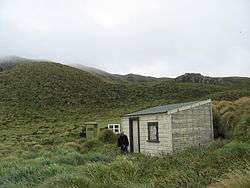
A well-supplied castaway depot[9] was available on the other end of the island, but the survivors' weak condition and the island's mountainous terrain prevented them from searching for depots.
The depot was found and used by the crew of the French barque President Felix Faure, wrecked in Anchorage bay in 1908, who were stranded for sixty days until rescued by HMS Pegasus.[10]
The last wreck at the Antipodes was the yacht Totorore with the loss of two lives, Gerry Clark and Roger Sale, in June 1999.[11]
Flora and fauna

The flora of the islands has been recorded in detail, and includes megaherbs. The islands are also home to numerous bird species including the endemic Antipodes snipe and Antipodes parakeet, as well as several albatrosses, petrels and penguins, including half of the world population of erect-crested penguins. Antipodes Island has introduced house mice.
Important Bird Area
The Antipodes group has been identified as an Important Bird Area (IBA) by BirdLife International because of its significance as a breeding site for several species of seabirds. The seabirds are southern rockhopper and erect-crested penguins, Antipodean, black-browed, light-mantled and white-capped albatrosses, and northern giant, grey and white-chinned petrels.[12]
Conservation
As with many other islands, introduced rodents have caused problems by preying on the indigenous wildlife. A "Million Dollar Mouse" campaign was launched in 2012 to raise funds for an eradication programme.[13] The Department of Conservation is planning to remove all mice from Antipodes Island in the winter of 2016.[14]
See also
- Composite Antarctic Gazetteer
- List of Antarctic and subantarctic islands
- List of islands of New Zealand
- New Zealand Subantarctic Islands
- Territorial claims in Antarctica
References
- ↑ Final counts – census night and census usually resident populations, and occupied dwellings - Area outside territorial authority Archived May 25, 2010, at the Wayback Machine., 2006 Census, Statistics New Zealand. Retrieved 26 August 2010.
- ↑ Antipodes, Liddell and Scott, "A Greek-English Lexicon", on Perseus.
- ↑ antipodes, Online Etymology Dictionary
- ↑ "Antipodes Islands: New Zealand's subantarctic islands". New Zealand Department of Conservation. Retrieved January 6, 2011.
- ↑ "Antipodes Islands". Twelve Mile Circle. Retrieved January 6, 2011.
- ↑ "Antipodes Island". Global Volcanism Program. Smithsonian Institution.
- ↑ "NGA-IWI-O-AOTEA". Te Ao Hou - The Maori Magazine (1967). Retrieved July 9, 2012.
- ↑ "Captain FAIRCHILD to the SECRETARY, Marine Department, Wellington". Appendix to the Journals of the House of Representatives, 1886 Session I, H-24 Page 6. Retrieved July 9, 2012.
- ↑ Items from the 1880s depot recovered in 1947 and now in the collection of the Museum of New Zealand Te Papa Tongarewa
- ↑ "Castaways rescued". Evening Post. New Zealand. 16 May 1908. p. 6.
- ↑ Imber, Michael J.; Scofield, R. Paul; Goodwin, Anthea; Tennyson, Alan J.D. (2000). "Obituary – Gerald Stanley (Gerry) Clark (1927-1999)." (PDF). Notornis. 49 (1): 55–58.
- ↑ BirdLife International. (2012). Important Bird Areas factsheet: Antipodes Islands. Downloaded from "Archived copy". Archived from the original on 2007-07-10. Retrieved 2013-05-07. on 2012-01-27.
- ↑ "Department of Conservation selling access to rare species". Stuff.co.nz. 10 June 2012. Retrieved 14 June 2012.
- ↑ O'Connor, Sarah-Jane. "Recommended by Plague of mice on subantarctic Antipodes Island may be living on borrowed time" (18 April 2016). Fairfax Media. Stuff.co.nz. Retrieved 19 April 2016.
Further reading
- Wise's New Zealand Guide (4th ed.) (1969). Dunedin: H. Wise & Co. (N.Z.) Ltd.
- "NGA-IWI-O-AOTEA". No. 59 (June 1967). Te Ao Hou - The Maori Magazine, pp. 43.
- Godley, E.J. The Botany of Antipodes Island. New Zealand Journal of Botany, 1989, Vol. 27: 531-563
- Entwisle, Peter (2005). Taka, A Vignette Life of William Tucker 1784–1817. Dunedin: Port Daniel Press. ISBN 0-473-10098-3.
- Taylor, Rowley, (2006) Straight Through from London, the Antipodes and Bounty Islands, New Zealand. Christchurch: Heritage Expeditions New Zealand Ltd. ISBN 0-473-10650-7.
- Marris, J.W.M. 2000: The beetle (Coleoptera) fauna of the Antipodes Islands, with comments on the impact of mice; and an annotated checklist of the insect and arachnid fauna. Journal of the Royal Society of New Zealand, 30: 169-195. ISSN 0303-6758 doi:10.1080/03014223.2000.9517616 PDF
- Warham, J.; Johns, P.M. 1975: The University of Canterbury Antipodes Island Expedition 1969. Journal of the Royal Society of New Zealand, 5(2): 103-131. ISSN 0303-6758 Google books
External links
- Antipodes Islands at the Department of Conservation
- Million Dollar Mouse campaign