Anse La Raye
Coordinates: 13°56′24″N 61°02′35″W / 13.9401°N 61.0431°W
| Anse la Raye | |
|---|---|
|
Anse la Raye, Saint Lucia | |
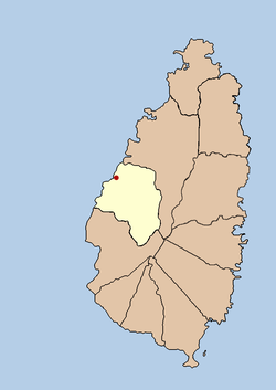 Map of Saint Lucia showing location of Anse la Raye | |
| Coordinates: 13°56′24″N 61°02′35″W / 13.9401°N 61.0431°W | |
| Country |
|
| Quarter | Anse la Raye Quarter |
| Founded | 18th Century |
| Founded by | The French |
| Named for | The rays found in the bay |
| Government | |
| • Governing body | Anse la Raye Village Council |
| Population (2005)[1] | |
| • Total | 6,382 (Anse la Raye Quarter) |
| Time zone | Eastern Caribbean Time Zone (ECT) (UTC-4) |
| Area code(s) | 758 |

Anse La Raye or Anse-La-Raye is the largest town in Anse la Raye Quarter, Saint Lucia; it is located on the island's western side, near Marigot Bay. It is a picturesque place with fine examples of French and English colonial architecture.[2]
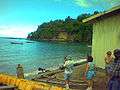
The name Anse la Raye is derived from the rays that are found in the bay, the English translation means Bay of Rays. Two rivers flow into the bay, these are the Grande Rivière de l'Anse la Raye and the Petite Rivière de l'Anse la Raye. On a Friday night there is a fish fry where the local fishermen showcase their skills and where lobsters, fish and lambi (conch) are cooked and eaten. The Fish Fry is located on Front Street which runs parallel to the beach.
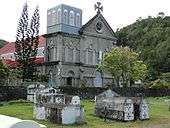
The local Catholic church was built in 1907, but records show that a chapel has existed since 1765. The present church has murals painted by the St Omer Family. Nearby attractions include the Anse la Raye Falls and the River Rock Falls.
Gallery
-

View of Anse la Raye
-

View from the Dock
-

Fishing boats at Anse la Raye
-
Seafront at Anse la Raye
References
Anse la Raye village website (www.anselaraye.com)
- ↑ http://www.stats.gov.lc
- ↑ site:"Archived copy". Archived from the original on 2012-05-20. Retrieved 2012-06-17. anse shows mix of spellings Anse La Raye and Anse-La-Raye