Anna Paulowna
| Anna Paulowna | |||
|---|---|---|---|
| Former municipality | |||
|
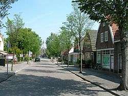
Church and the old center of the village Anna Paulowna. | |||
| |||
 | |||
| Coordinates: 52°52′N 4°52′E / 52.87°N 4.87°ECoordinates: 52°52′N 4°52′E / 52.87°N 4.87°E | |||
| Country | Netherlands | ||
| Province | North Holland | ||
| Municipality | Hollands Kroon | ||
| Area(2006) | |||
| • Total | 78.81 km2 (30.43 sq mi) | ||
| • Land | 74.43 km2 (28.74 sq mi) | ||
| • Water | 4.38 km2 (1.69 sq mi) | ||
| Population (1 January 2007) | |||
| • Total | 13,999 | ||
| • Density | 188/km2 (490/sq mi) | ||
| Source: CBS, Statline. | |||
| Time zone | CET (UTC+1) | ||
| • Summer (DST) | CEST (UTC+2) | ||
| Postcode | 1760-1766 | ||
| Area code(s) | 0223, 0224 | ||
| Website | www.annapaulowna.nl | ||


Anna Paulowna (![]() pronunciation ) is a former municipality and a town in the Netherlands, in the province of North Holland. The former municipality derives its name from the Anna Paulownapolder, which was laid dry in 1846 during the reign of King William II of the Netherlands and in turn named after his wife, Queen Anna Paulowna of Russia. Since 2012, Anna Paulowna has been a part of the new municipality of Hollands Kroon.
pronunciation ) is a former municipality and a town in the Netherlands, in the province of North Holland. The former municipality derives its name from the Anna Paulownapolder, which was laid dry in 1846 during the reign of King William II of the Netherlands and in turn named after his wife, Queen Anna Paulowna of Russia. Since 2012, Anna Paulowna has been a part of the new municipality of Hollands Kroon.
Population centres
The former municipality of Anna Paulowna consisted of the following cities, towns, villages and/or districts: Anna Paulowna, Breezand, Nieuwesluis, Van Ewijcksluis, and Wieringerwaard.
Transportation
The town is served by Anna Paulowna railway station.
Local government
The former municipal council of Anna Paulowna consisted of 15 seats. After the Dutch municipal elections of 2010 the seats were divided as follows:
References
- Statistics are taken from the SDU Staatscourant
See also
![]() Media related to Anna Paulowna at Wikimedia Commons
Media related to Anna Paulowna at Wikimedia Commons