Anderlues
| Anderlues | |||
|---|---|---|---|
| Municipality | |||
|
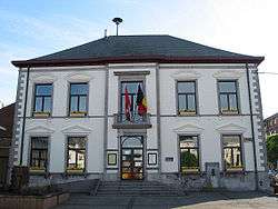
Anderlues town hall | |||
| |||
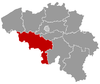
 Anderlues Location in Belgium | |||
|
Location of Anderlues in Hainaut 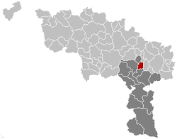 | |||
| Coordinates: 50°24′N 04°16′E / 50.400°N 4.267°ECoordinates: 50°24′N 04°16′E / 50.400°N 4.267°E | |||
| Country | Belgium | ||
| Community | French Community | ||
| Region | Wallonia | ||
| Province | Hainaut | ||
| Arrondissement | Thuin | ||
| Government | |||
| • Mayor | Philippe Tison (PS) | ||
| • Governing party/ies | PS, MR | ||
| Area | |||
| • Total | 17.02 km2 (6.57 sq mi) | ||
| Population (1 January 2016)[1] | |||
| • Total | 12,012 | ||
| • Density | 710/km2 (1,800/sq mi) | ||
| Postal codes | 6150 | ||
| Area codes | 071 | ||
| Website | www.anderlues.be | ||


Anderlues is a Walloon municipality located in the Belgian province of Hainaut. On January 1, 2006, Anderlues had a total population of 11,578. The total area is 17.02 square kilometres (6.57 sq mi) which gives a population density of 680 inhabitants per square kilometre. Its postcode is 6150.
On December 1, 1983, a local jewellery store was robbed by the Nijvel gang. Some low-value jewels were stolen and two people were killed in what was the gang's last robbery before going silent for one year.
References
- ↑ Population per municipality as of 1 January 2016 (XLS; 397 KB)
External links
-
 Media related to Anderlues at Wikimedia Commons
 |
Morlanwelz, Chapelle-lez-Herlaimont | | ||
| Binche | |
Fontaine-l'Évêque | ||
| ||||
| | ||||
| Lobbes |
This article is issued from Wikipedia - version of the 12/1/2016. The text is available under the Creative Commons Attribution/Share Alike but additional terms may apply for the media files.