Andasibe-Mantadia National Park
| Andasibe-Mantadia National Park | |
|---|---|
|
IUCN category II (national park) | |
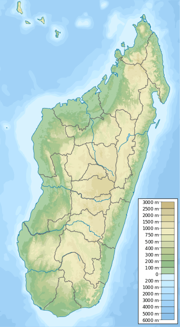 Location of Mantadia National Park | |
| Location | Eastern Madagascar |
| Nearest city | Moramanga, Andasibe (Périnet) |
| Coordinates | 18°49′36″S 48°26′52″E / 18.82667°S 48.44778°ECoordinates: 18°49′36″S 48°26′52″E / 18.82667°S 48.44778°E |
| Area | 155 km2 |
| Established | 1989 |
| Visitors | 22110 (in 2006) |
| Governing body | Madagascar National Parks Association (PNM-ANGAP) |
Andasibe-Mantadia National Park is a 155 square kilometre protected area, located about 150 km east of Antananarivo, consisting principally of primary growth forest in Alaotra-Mangoro Region in eastern Madagascar. The park's elevation ranges from 800–1260 meters, with a humid climate. Average annual precipitation is 1700 mm, with rainfall on 210 days of each year. This rainforest is habitat to a vast species biodiversity, including many endemic rare species and endangered species, including 11 lemur species. The park's two component parts are Mantadia National Park and Analamazoatra Reserve, which is best known for its population of Madagascar's largest lemur, the indri.[1]
This national park was nominated in 2007 to become part of the World Heritage Site of Rainforests of the Atsinanana. [2] But these forests were not selected for the final list.[3]
This is one of the easiest parks in Madagascar to visit from the capital city, Antananarivo, with a 3-hour drive east on a paved road, Route Nationale 2 (RN 2). While Analamazaotra and park headquarters are short walks from Antsapanana on the RN 2, special transport must be arranged or hired from local hotels to reach Mantadia. Hikes ranging from 1–6 hours are typically available in both parts of the park. A local guide is required for visitors entering either part of the park.
History
The Analamazaotra (or Périnet) Special Reserve (ASR), known locally as Andasibe after the nearby village, was once part of the larger Mantadia National Park which also included Maromizaha Classified Forest to the southeast and Anosibe an’ala to the south. However logging and deforestation for farming has resulted in these parks now being isolated.[1][4]
The main threat to this park comes from the disappearance of adjoining habitat outside the park. This disappearance has been caused primarily by logging and replacement of rain-forest with commercial Australian eucalyptus and Chinese pine forests, and to a lesser extent by slash-and-burn cultivation for rice agriculture, which is exacerbated by the extremely high population growth rate and poverty in rural Madagascar.
Reintroduction program

To address the disappearing habitat threat, reserves have been created in the vicinity of Andasibe-Mantadia that balance resource extraction with environmental protection, and attempt to create economic and environmentally preferable alternatives to replacing native forests with eucalyptus and pine.
In 2006 the Analamazaotra Re-introduction/Translocation (ART) project was initiated to reintroduce two endangered species of lemur back into the park. The aim was to take lemurs from threatened areas where habitat loss means the incumbent population is unsustainable, and relocate them to the relative safety of the Analamazaotra Special Reserve. The program followed the IUCN re-introduction/translocation guidelines, with family group monitoring before and after translocation.[4]
By 2014, the ART project had reintroduced three group comprising 26 diademed sifaka and 8 black-and-white ruffed lemur into the park. The project's multi-disciplinary team tracked the reintroduced groups using radio collars, and collected fecal samples to evaluate biomedical, genetic, habitat, nutritional and reproductive characteristics of the lemurs.
The project has so far been very successful, and visitors to this popular reserve have been lucky enough to see two generations of babies born at the park. The ART project also helps the local community by education and provides two local guides.[4]
-

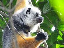
Diademed sifaka with radio collar in Andasibe-Mantadia National Park
-

Terrestrial crab in Andasibe-Mantadia National Park
-

Indri resting after feeding in Andasibe-Mantadia National Park

See also
- Aye-aye (nocturnal)
- Black and white ruffed lemur
- Brown mouse lemur (nocturnal)
- Common brown lemur
- Diademed sifaka
- Gray bamboo lemur
- Eastern woolly lemur
- Greater dwarf lemur (nocturnal)
- Indri
- Red-bellied lemur
- National parks of Madagascar
References
- 1 2 Bradt, Hilary. Madagascar: The Bradt Travel Guide (7th ed.). Bradt Travel Guides. pp. 307–311. ISBN 1841620513.
- ↑ Africa, Rainforests of the Atsinanana, Madagascar" . UNESCO Organization.
- ↑ Rainforests of the . UNESCO Organization.
- 1 2 3 "Madagascar Biodiversity Partnership". www.madagascarpartnership.org. Retrieved 8 September 2014.
External links
| Wikivoyage has a travel guide for Andasibe-Mantadia National Park. |
![]() Media related to Andasibe-Mantadia National Park at Wikimedia Commons
Media related to Andasibe-Mantadia National Park at Wikimedia Commons
| Strict Nature Reserves |  | |
|---|---|---|
| National parks | ||
| Wildlife Reserves | ||