Ancinnes
| Ancinnes | |
|---|---|
 | |
 Ancinnes | |
|
Location within Pays de la Loire region  Ancinnes | |
| Coordinates: 48°22′06″N 0°10′39″E / 48.3683°N 0.1775°ECoordinates: 48°22′06″N 0°10′39″E / 48.3683°N 0.1775°E | |
| Country | France |
| Region | Pays de la Loire |
| Department | Sarthe |
| Arrondissement | Mamers |
| Canton | Saint-Paterne |
| Intercommunality | Communauté de communes des Portes du Maine Normand |
| Government | |
| • Mayor (2008–2014) | Jean-Yves Pottier (DLR) |
| Area1 | 27.21 km2 (10.51 sq mi) |
| Population (2006)2 | 899 |
| • Density | 33/km2 (86/sq mi) |
| Time zone | CET (UTC+1) |
| • Summer (DST) | CEST (UTC+2) |
| INSEE/Postal code | 72005 / 72610 |
| Elevation | 92–242 m (302–794 ft) |
|
1 French Land Register data, which excludes lakes, ponds, glaciers > 1 km² (0.386 sq mi or 247 acres) and river estuaries. 2 Population without double counting: residents of multiple communes (e.g., students and military personnel) only counted once. | |
Ancinnes is a commune in the Sarthe department in the region of Pays-de-la-Loire in north-western France.
It lies within the Parc naturel régional Normandie-Maine and is on the edge of the forest of Perseigne.
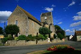
It is 8 km from Alençon, the capital of the Orne department and the nearest major town. The commune of Ancinnes has approximately 1,100 residents, called "Ancinnois". The village is centred on the Church of Saint Peter and Saint Paul.
See also
References
External links
| Wikimedia Commons has media related to Ancinnes. |
This article is issued from Wikipedia - version of the 7/7/2016. The text is available under the Creative Commons Attribution/Share Alike but additional terms may apply for the media files.