Amur Acquisition
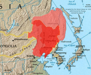
The Amur Annexation refers to the incorporation of the southeast corner of Siberia into Russia in 1858–60. The two areas involved are the Priamurye between the Amur River and the Stanovoy Range to the north and the Primorye which runs down the coast from the Amur mouth to the Korean border; and does not include Sakhalin Island. The territory of Outer Manchuria was formerly under the control of the Qing dynasty.
In the modern-day geography of Russia, Priamurye ("the Amur Lands") roughly corresponds to the Amur Oblast and the southern half of the Khabarovsk Krai, while Primorye ("the Maritime Lands") corresponds to the Primorsky Krai (and, possibly, adjacent sections of Khabarovsk Krai).
Background
Hydrologically, the Stanovoy Mountains separate the rivers that flow north into the Arctic from those that flow south into the Amur River. Ecologically, the area is the southeastern edge of the Siberian boreal forest with some areas good for agriculture along the middle Amur. Socially and politically, from about 600 AD, it was the northern fringe of the Chinese-Korean-Manchu world. For a Chinese view of this, see Outer Manchuria and Hulun (Manchuria).
In 1643 Russian adventurers spilled over the Stanovoys, but by 1689 they were driven back by the Manchus. For this, see Sino-Russian border conflicts. By the Treaty of Nerchinsk (1689) the two empires recognized the Stanovoys and the Argun River as their border. This remained stable until the 1840s.
Following the voyages of Captain James Cook significant numbers of British, French and American vessels began entering the Pacific. They were followed by Russians like Grigory Shelikhov and Nikolai Rezanov who were mainly concerned with the new Russian colonies in Alaska. This raised the problem of naval defense of the east coast of Siberia and the possibility of using the Amur River as a supply route to the Pacific.
Muravyov and the Treaty of Aigun (1858)
In 1845 Alexander von Middendorf entered the Amur country and wrote a report. In 1847 Aleksandr Gavrilov reached the mouth of the Amur but could not find a deep-water entrance.
In 1848 Gennady Nevelskoy was sent in the 'Baikal' to explore the Pacific coast. In 1849 he sailed part way up the Amur and then sailed south through the Tatar Strait, thereby proving that Sakhalin was an island, a fact that was kept a military secret. In 1850 he founded Nikolayevsk-on-Amur on what was alleged Chinese territory. Karl Nesselrode, the foreign minister, tried to overrule this, but Nicholas I declared the 'where once the Russian flag is raised, it must not be lowered.' In the next three years, Nevelskoy established other forts on the alleged Chinese territory around the mouth of the Amur.
In 1847 Nikolay Muravyov was appointed governor-general of East Siberia. Before leaving for Irkutsk he arranged for the creation of an Amur Committee to coordinate work in the area. In 1849 he made an overland trip to Okhotsk and then to Petropavlovsk-Kamchatsky. One result of this was the removal of the main naval center from Okhotsk to Petropavlovsk. To give himself a military force he created a new Cossack host, the Transbaikalian Cossacks, by arming 20,000 mining serfs. In May–June 1854 he and 1,000 men sailed down the Amur to Nikolayevsk. The Manchu governor at Aigun had no choice but to let them pass.
News of the Crimean War reached the far east in July. In September an Anglo-French naval force was defeated at the Siege of Petropavlovsk. Judging that Petropavlovsk could not be defended, Muravyov ordered Rear Admiral Vasily Zavoyko to move his forces to the Amur area. In May 1855 Charles Elliot's force found Zavoyko at De Kastri Bay (south of Cape Nevelskoy on the Tartar Strait). Under cover of fog, Zavoiko withdrew north to the mouth of the Amur, which baffled the British since they thought that Sakhalin was connected to the mainland.
In 1855 Muravyov sent a 3,000 man force down the Amur, including settlers. The Chinese declared this to be illegal, but did nothing. Also, in 1855 Russia and Japan signed the Treaty of Shimoda which temporarily resolved their conflict in Sakhalin and the Kuril Islands. The Russian representative was Admiral Putyatin (see below).
The Second Opium War broke out in 1856. By 1858 the British and French had captured Canton. When news of this reached Saint Petersburg, the foreign minister, Alexander Gorchakov, who had replaced Nesselrode, decided that it was time to "activate Russian Far Eastern Policy.' Muravyov was given plenipotentiary powers and Admiral Yevfimy Putyatin was sent to Peking to negotiate a more favorable relation.
In 1856 and 1857 Muravyov sent more settlers down the Amur. In 1858 he went himself. His instructions were not to use force except to rescue captives. On reaching Aigun he presented the local governor with a treaty, which was signed. This "Treaty of Aigun" basically assigned all the land north of the Amur to Russia and declared the area east of the Ussuri River and south of the Amur (northern Primorye) to be a Russo-Chinese condominium until further negotiations.
Muravyov continued down the Amur and founded Khabarovsk at the mouth of the Ussuri. Next September, Alexander II promoted him to full general and granted him the suffix '-Amursky'. In 1859 he sent an exploring expedition down the coast as far as Vladivostok.
Putyatin, Ignatyev and the Convention of Peking (1860)
Meanwhile, Admiral Yevfimy Putyatin was travelling overland to China. Reaching Kyakhta, he was refused entry (spring of 1857), so he sailed down the Amur and took ship to Tientsin. Refused entry again, he joined the British and French at Shanghai. When the allies took the Taku Forts Putyatin offered himself as a mediator. The result was the Treaties of Tientsin which granted most of the allied demands. Without fully informing the allies, Putyatin made a separate deal with the Chinese (June 13, 1858). In return for cannon, 20,000 rifles and military instructors the frontier would be adjusted in some unspecified way (Putyatin was not aware of the Treaty of Aigun which had been signed 16 days earlier.)
After the allies withdrew the Chinese failed to implement the treaties. The allies returned in June 1859, attempted to retake the Taku Forts and failed. As a result, the Chinese refused to ratify the treaties.
At this point a 27-year-old Major General named Nikolay Pavlovich Ignatyev entered the picture. In March 1859 he was assigned to accompany the Russian weapons and instructors. At the frontier he found that the Chinese had rejected the treaties and would not accept the weapons. He continued to Peking where he stayed at the Russian ecclesiastical mission and attempted to negotiate with the Manchus. Hearing of allied preparations, he joined the British and French in Shanghai and proved to be most helpful to the allied councils (he had a map of Peking and good interpreters). By October 1860 the British and French had retaken the Taku forts and entered Peking and the Emperor had fled to Jehol. Ignatyev now placed himself as an intermediary between the Europeans and Chinese. By the first two Treaties of Peking (October 24 and 25, 1860) nearly all the allied demands were met. Ignatyev continued negotiations for a Russo-Chinese treaty. He convinced the Chinese that only his support would cause the allies to leave the capital. The result was the Russo-Chinese Convention of Peking of November 14, 1860. By this, the Treaty of Tientsin was ratified and all the land north of the Amur and east of the Ussuri was ceded to Russia.
Thus, by pure diplomacy and only a few thousand troops, the Russians took advantage of Chinese weakness and the strength of the other European powers to annex 350,000 square miles (910,000 km2) of Chinese territory. With the exception of Muravyov's rather ceremonial cannonade at Aigun, they had apparently not fired a single shot.
Consequences
A consequence of the acquisition was the Chuang Guandong, the opening of the "remainder" of the Manchuria to large-scale settlement by Han Chinese farmers.
References
- G. Patrick March, 'Eastern Destiny: Russia in Asia and the North Pacific, 1996