Amritsar
| Amritsar ਅੰਮ੍ਰਿਤਸਰ (Punjabi) | |
|---|---|
|
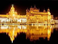
Night view of the Harmandir Sahib | |
 Amritsar  Amritsar | |
| Coordinates: 31°38′N 74°52′E / 31.64°N 74.86°ECoordinates: 31°38′N 74°52′E / 31.64°N 74.86°E | |
| Country |
|
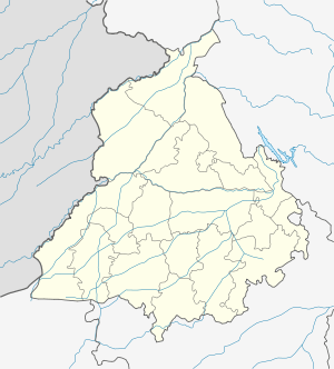
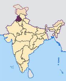
| State | Punjab |
| District | Amritsar |
| Founded by | Guru Ram Das |
| Government | |
| • Commissioner of Police | Sh. Amar Singh Chahal, IPS |
| • Deputy commissioner | Varun Roojam |
| Population (2011) | |
| • Urban[1] | 1,132,761 |
| • Metro[2] | 1,183,705 |
| Demonym(s) | Amritsari (Ambarsariya) |
| Time zone | IST (UTC+5:30) |
| PIN | 143-001 |
| Telephone code | 91 183 XXX XXXX |
| Vehicle registration | PB-02 |
| Website |
www |
Amritsar (![]() pronunciation ; Punjabi: ਅੰਮ੍ਰਿਤਸਰ; Punjabi pronunciation: [əmːɾɪt̪səɾ]), historically also known as Rāmdāspur and colloquially as Ambarsar, is a city in north-western India which is the administrative headquarters of the Amritsar district - located in the Majha region of the Indian state of Punjab.
pronunciation ; Punjabi: ਅੰਮ੍ਰਿਤਸਰ; Punjabi pronunciation: [əmːɾɪt̪səɾ]), historically also known as Rāmdāspur and colloquially as Ambarsar, is a city in north-western India which is the administrative headquarters of the Amritsar district - located in the Majha region of the Indian state of Punjab.
According to the 2011 census, the population of Amritsar was 1,132,761. The city is situated 217 km (135 mi) northwest of state capital Chandigarh. It is near Pakistan, with the Wagah Border being only 28 km (17.4 mi) away. The nearest city is Lahore, the second largest city in Pakistan, located 50 km (31.1 mi) to the west.
Hinduism and Sikhism are the main religions of Amritsar city, practised by 49.4% and 48% of the total population, respectively.[3]
Amritsar is home to the Harmandir Sahib (commonly known as the Golden Temple), the spiritual and cultural centre for the Sikh religion. This important Sikh shrine attracts more visitors than the Taj Mahal with more than 100,000 visitors on weekdays alone and is the most popular destination for non-resident Indians (NRI) in the whole of India. The city also houses the Akal Takht, the highest seat of earthly authority of the Khalsa, and the committee responsible for the upkeep of Gurdwaras.
The Ramtirth temple situated at Amritsar is believed to be the Ashram site of Maharishi Valmiki, the writer of Ramayana.[4] According to the Hindu mythology, Goddess Sita gave birth to Lava and Kusha, sons of lord Rama at Ramtirth ashram. Large number of people visit Ramtirth Temple at annual fair. Nearby cities to Amritsar, Lahore and Kasoor were said to be founded by Lava and Kusha, respectively. During Ashvamedha Yagna by Lord Rama, Lava and Kush captured the ritual horse and tied Lord Hanuman to a tree near to today's Durgiana Temple. During Navratra festivities it is considered to be auspicious by Hindu population of the city to visit that temple.[5]
The main commercial activities of Amritsar include tourism, carpets and fabrics, farm produce, handicrafts, service trades, and light engineering. The city is known for its rich cuisine, and culture, and for the Jallianwala Bagh massacre in 1919 under British Rule. Amritsar is home to Central Khalsa Orphanage, which was once home to Udham Singh, a prominent figure in the Indian independence movement. Gandhi Ground is the main sports complex in the city which is home to the Amritsar Games Association, (AGA).
Amritsar has been chosen as one of the heritage cities for HRIDAY - Heritage City Development and Augmentation Yojana scheme of Government of India.[6]
History

Amritsar is one of the largest cities of the Punjab state in India. The city origin lies in the village of Tung, and was named after the lake founded by the fourth Sikh Guru Ram Das in 1574 on land bought by him for 700 rupees from the owners of the village of Tung.[7] Earlier, Guru Ram Das had begun building Santokhsar Sarovar, near the village of Sultanwind in 1564 (according to one source in 1570). It could not be completed before 1588. In 1574, Guru Ram Das built his residence and moved to this place. At that time, it was known as Guru Da Chakk. (Later, it came to be known as Chakk Ram Das.)
Amritsar's central walled city has narrow streets mostly developed in the 17th and 18th century. The city is a peculiar example of an introverted planning system with unique areas called Katras. The Katras are self-styled residential units that provided unique defence system during attacks on the city.
Jallianwala Bagh massacre

The Jallianwala Bagh massacre, involving the killing of hundreds of Indian civilians on the orders of a senior British military officer, Reginald Edward Harry Dyer, took place on 13 April 1919 in the heart of Amritsar, the holiest city of the Sikhs, on a day sacred to them as the birth anniversary of the Khalsa (Vaisakhi day).
In the Punjab, during World War I (1914–18), there was considerable unrest particularly among the Sikhs, first on account of the demolition of a boundary wall of Gurdwara Rakab Ganj at New Delhi and later because of the activities and trials of the Ghadarites, almost all of whom were Sikhs. In India as a whole, too, there had been a spurt in political activity mainly owing to the emergence of two leaders: Mahatma Gandhi (1869–1948) who after a period of struggle against the British in South Africa, had returned to India in January 1915, and Annie Besant (1847–1933), head of the Theosophical Society of India, who on 11 April 1916 established the Home Rule League with autonomy for India as its goal. In December 1916, the Indian National Congress, at its annual session held at Lucknow, passed a resolution asking the king to issue a proclamation announcing that it is the "aim and intention of British policy to confer self-government on India at an early date".[8]
On 10 April 1919, Satya Pal and Saifuddin Kitchlew, two popular proponents of the Satyagraha movement led by Gandhi, were called to the deputy commissioner's residence, arrested and sent off by car to Dharamsetla, a hill town, now in Himachal Pradesh. This led to a general strike in Amritsar. Excited groups of citizens soon merged into a crowd of about 50,000 marching on to protest to the deputy commissioner against the arrest of the two leaders. The crowd, however, was stopped and fired upon near the railway foot-bridge. According to the official version, the number of those killed was 12 and of those wounded between 20 and 30. Evidence before an inquiry of the Indian National Congress put the number of the dead between 20 and 30.
Three days later, on 13 April, the traditional festival of Baisakhi, thousands of Sikhs, Muslims and Hindus gathered in the Jallianwala Bagh. An hour after the meeting began as scheduled at 16:30, Dyer arrived with a group of sixty-five Gurkha and twenty-five Baluchi soldiers. Without warning the crowd to disperse, Dyer blocked the main exits and ordered his troops to begin shooting toward the densest sections of the crowd. Firing continued for approximately ten minutes. A British inquiry into the massacre placed the death toll at 379. The Indian National Congress determined that approximately 1,000 people were killed.
Partition of 1947
Partition of British India into India and Pakistan had a most profound effect on the demographics, economics, culture, political and social structures of Amritsar. The state of Punjab was divided between India and Pakistan and Amritsar became a border city, often on the front lines of India-Pakistan wars. Prior to partition, the Muslim league wanted to incorporate Amritsar into Pakistan because of the Amritsar's proximity to Lahore (a distance of 30 miles) and a nearly 50% Muslim population, but the city became part of India. The Indian National Congress had similar aims of incorporating Lahore into India as Lahore was the cultural, economic, and political capital of undivided Punjab and Hindus and Sikhs constituted nearly 50% of the population, but Lahore became a part of Pakistan. Amritsar and Lahore experienced some of the worst communal riots during the partition of India. Muslim residents of Amritsar left the city en-masse leaving their homes and property behind because of violent anti-Muslim riots in Amritsar. Similar scenes of communal carnage against Hindus and Sikhs were witnessed in Lahore and led to their mass evacuation.
Important Muslim dominated villages in Amritsar district prior to partition include Sultanpur, Kala Afgana, Abdul Kalan, Rasheed Bal, Lahorie, Shahpur, Shahkot, Alipur, Aliwal, Allahbad, Fatehbad, Chak, Guza Chak, Jattan, Cheema.
Operation Blue Star
Operation Blue Star (3– 6 June 1984) was an Indian military operation ordered by Indira Gandhi, then Prime Minister of India[9] to curb and remove Sikh militants from the Golden Temple in Amritsar. The operation was carried out by Indian army troops with tanks and armoured vehicles.[10] Militarily successful, the operation aroused immense controversy, and the government's justification for the timing and style of the attack are hotly debated.[11] Operation Blue Star was included in the Top 10 Political Disgraces by India Today magazine.[12]
Official reports put the number of deaths among the Indian army at 83.[13][14] In addition, the CBI is considered responsible for seizing historical artefacts and manuscripts in the Sikh Reference Library before burning it down.[15] [16] Four months after the operation, on 31 October 1984, Indira Gandhi was assassinated by two of her Sikh bodyguards in what is viewed as an act of vengeance. Following her assassination, more than 3,000 Sikhs were killed in anti-Sikh pogroms.[17] Within the Sikh community itself, Operation Blue Star has taken on considerable historical significance.
Geography and climate
Amritsar is located at 31°38′N 74°52′E / 31.63°N 74.87°E[18] with an average elevation of 234 metres (768 ft).
Amritsar has a semiarid climate, typical of Northwestern India and experiences four seasons primarily: winter season (December to March) with temperature ranges from 0 °C (32 °F) to about 15 °C (59 °F), summer season (April to June) where temperatures can reach 42 °C (108 °F), monsoon season (July to September) and post-monsoon season (October to November). Annual rainfall is about 681 millimetres (26.8 in).[19] The lowest recorded temperature is −7.6 °C (18.3 °F), was recorded on 9 December 1996 and the highest temperature, 48.1 °C (118.6 °F), was recorded on 22 May 2013.[20][21]
| Climate data for Amritsar | |||||||||||||
|---|---|---|---|---|---|---|---|---|---|---|---|---|---|
| Month | Jan | Feb | Mar | Apr | May | Jun | Jul | Aug | Sep | Oct | Nov | Dec | Year |
| Record high °C (°F) | 29.0 (84.2) |
31.1 (88) |
35.7 (96.3) |
41.9 (107.4) |
48.1 (118.6) |
46.2 (115.2) |
42.0 (107.6) |
37.2 (99) |
36.5 (97.7) |
34.6 (94.3) |
29.3 (84.7) |
23.2 (73.8) |
48.1 (118.6) |
| Average high °C (°F) | 19.4 (66.9) |
21.6 (70.9) |
26.5 (79.7) |
33.8 (92.8) |
38.7 (101.7) |
39.4 (102.9) |
35.0 (95) |
34.2 (93.6) |
34.5 (94.1) |
32.3 (90.1) |
27.1 (80.8) |
21.3 (70.3) |
30.3 (86.5) |
| Daily mean °C (°F) | 11.6 (52.9) |
13.9 (57) |
18.7 (65.7) |
25.1 (77.2) |
29.9 (85.8) |
32.1 (89.8) |
30.2 (86.4) |
29.7 (85.5) |
28.3 (82.9) |
23.8 (74.8) |
17.9 (64.2) |
12.9 (55.2) |
22.8 (73) |
| Average low °C (°F) | 3.7 (38.7) |
6.0 (42.8) |
10.9 (51.6) |
16.3 (61.3) |
21.1 (70) |
24.6 (76.3) |
25.3 (77.5) |
25.1 (77.2) |
22.2 (72) |
15.1 (59.2) |
8.7 (47.7) |
4.4 (39.9) |
15.3 (59.5) |
| Record low °C (°F) | −3.5 (25.7) |
−1.6 (29.1) |
2.6 (36.7) |
5.7 (42.3) |
7.7 (45.9) |
13.8 (56.8) |
14.0 (57.2) |
15.0 (59) |
10.5 (50.9) |
4.6 (40.3) |
1.7 (35.1) |
−2.7 (27.1) |
−3.5 (25.7) |
| Average rainfall mm (inches) | 24 (0.94) |
33 (1.3) |
48 (1.89) |
29 (1.14) |
25 (0.98) |
62 (2.44) |
231 (9.09) |
187 (7.36) |
79 (3.11) |
18 (0.71) |
6 (0.24) |
18 (0.71) |
760 (29.91) |
| Average rainy days (≥ 1.0 mm) | 2.8 | 3.7 | 5.0 | 3.5 | 2.8 | 4.6 | 11.4 | 9.1 | 4.3 | 1.4 | 1.2 | 2.0 | 51.8 |
| Average relative humidity (%) | 74 | 70 | 64 | 47 | 38 | 48 | 72 | 77 | 69 | 67 | 73 | 76 | 64.6 |
| Mean monthly sunshine hours | 181.7 | 192.7 | 219.4 | 265.0 | 294.7 | 269.0 | 215.5 | 227.7 | 240.8 | 253.2 | 220.1 | 182.2 | 2,762 |
| Source: [20][22] | |||||||||||||
Administrative towns
Demographics
As of the 2011 census, Amritsar municipality had a population of 1,132,761[1] and the urban agglomeration had a population of 1,183,705.[2] The municipality had a sex ratio of 879 females per 1,000 males and 9.7% of the population were under six years old.[1] Effective literacy was 85.27%; male literacy was 88.09% and female literacy was 82.09%.[1]
Amritsar municipality had a population of 1,132,761[1] and the urban agglomeration had a population of 1,183,705.[2] The municipality had a sex ratio of 879 females per 1,000 males and 9.7% of the population were under six years old.[1] Effective literacy was 85.27%; male literacy was 88.09% and female literacy was 82.09%.[1] The scheduled caste population is 28.8%[23]
Religion
Amritsar is a holy city for the Sikhs. As of the 2011 Census of India, Hinduism and Sikhism are the main religions of Amritsar city with 49.36% and 48% of the people following them. Inspite of this, Sikhs form a majority of almost 70% in the Amritsar District on a whole. In Amritsar city, Christianity was followed by 1.23% and Islam by 0.51%. Around 0.74% of the population of the city stated 'No Particular Religion' or another religion.[25]
Transport
The city lies on the main Grand Trunk Road (GT Road) from Delhi to Amritsar connecting to Lahore in Pakistan. The G. T. Road, built by Sher Shah Suri, runs through the whole of the northern half of the Indian subcontinent, connecting Peshawar, Pakistan to Sonargaon, Bangladesh. The city is also connected to most other major cities such as New Delhi, Mumbai, Calcutta by an extensive network of rail system. The city also provides air connectivity to major Indian cities, as well as foreign cities such as Birmingham, Toronto, Dubai, Singapore, Tashkent, Ashgabat, London etc. from Guru Ramdas International Airport (formerly the Raja Sansi International Airport). The airport is being developed for increasing demand in future; a new International inbound and outbound terminal is operational, and a cargo terminal is under construction. The city is the administrative centre for the Amritsar District. However, it did not become the industrial centre of Punjab because of its proximity to the volatile Indo-Pakistan border.
Air
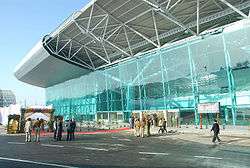
Amritsar's international airport, Sri Guru Ram Dass Jee International Airport, has more than 250 domestic and international flights during the week with daily connections to Delhi, Mumbai, Kolkata, Chennai, Bangalore, and Srinagar etc. in India and international flights to London(Heathrow), Birmingham, Melbourne and Sydney via Delhi. Also it has direct flights to Doha, Ashgabat, Kuala lumpur, Singapore, Tashkent and Dubai.
Allama Iqbal International Airport is about 30 kilometres (19 mi) west of Amritsar, in Lahore, Pakistan.
Rail
Amritsar is well connected by rail to almost all major cities in India. Amritsar railway station is the main terminal station. There is a special train (Samjhauta Express) that runs west to Wagah (Attari Border), which is the last station on the border in India before continuing on to Pakistan.
Indian Railways has proposed a high-speed rail line to serve Delhi-Amritsar via Ambala. The train is to run at high speeds of 160 km/h, second only in India to the Bhopal Shatabdi Express. It will travel the 445 km between the two cities in 2.5 hours (compared to the current time of 5 hours). Companies from Japan, China, UK and Canada have expressed an interest in the project. The contract for building the line were to be awarded at the end of May 2008. Other lines of this kind have proposed in Mumbai, Ahmedabad, Pune, and Kolkata.[26][27][28] Amritsar railway station has 6 platforms namely 1a.1–5.
Important Trains :
- Amritsar Shatabdi Express
- New Delhi Amritsar Swarna Shatabdi Express
- Amritsar Haridwar Jan Shatabdi Express
Road

Amritsar is located on the historic Grand Trunk Road (G.T Road), also known as National Highway 1, and therefore very well connected to the road network. Daily bus services run to and from Ambala, Patiala, Delhi, Chandigarh and Jammu. Rs 450,000,000 is being spent to expand the Amritsar-Jalandhar stretch of G.T. Road to four lanes. In 2010, elevated road with four lanes connected to the National highway for better access to the Golden Temple has been started.[29]
For transportation within Amritsar city, rickshaws, auto rickshaws, taxis and buses are easily available. Buses are available from Amritsar to Chandigarh,[30] Delhi, Shimla, Jalandhar, Ludhiana. Now bus tickets can be booked online.
Amritsar BRTS
Recently, the government of India and Punjab pledged Rs. 580 crore (100 million dollars) for the Amritsar BRTS for the city.[31] It is hoped that Amritsar BRTS will help relieve traffic congestion and improve air quality.
City bus service was also introduced in the city. Amritsar is also connected with Lahore, Pakistan via the old Grand Trunk Road.
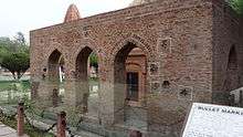
Tourist places in Amritsar
'%2C_oil_on_canvas_painting_by_Charles_W._Bartlett%2C_1920%2C_Honolulu_Academy_of_Arts.jpg)
Educational institutions
- Amritsar College of Engineering and Technology
- BBK DAV College for Women, Amritsar
- Delhi Public School, Amritsar
- Global Institute, Amritsar
- Government Medical College, Amritsar
- Guru Nanak Dev University
- Indian Institute of Management, Amritsar
- Khalsa College, Amritsar
- St. Francis School, Amritsar
- DAV College, Amritsar
- Holy Heart Presidency School
- Police DAV Public School, Amritsar
Notable residents
- A Hameed, writer
- Akshay Kumar, Indian actor
- Amrinder Gill, Punjabi singer
- Baba Deep Singh, General
- Bhagat Puran Singh, Environmentalist
- Bhagat Singh Thind,[33] US Sikh Leader
- Bharti Singh, Indian stand-up comedian
- Bhisham Sahni, Hindi writer
- Bishan Singh Bedi, cricketer
- Chandan Prabhakar, comedian
- Dalbir Chetan, Punjabi short-story writer[34]
- Dara Singh, wrestler-Indian actor
- Deepa Mehta, Indo-Canadian filmmaker
- Deepti Naval, Indian actress
- Geeta Bali, Indian actress
- Ghulam Abbas (writer)
- Guru Tegh Bahadur, 9th Guru of Sikhs
- Hans Raj Khanna, judge at the Supreme court of India
- Jeetendra, Indian actor
- Kapil Sharma, comedian
- Kiran Bedi, first woman IPS officer of India
- Krishan Kant, 10th Vice-President of India
- Laxmi Kanta Chawla
- Madan Lal Dhingra, independence activist & convicted murderer
- Madan Lal, cricketer
- Mahendra Kapoor, Indian playback singer
- Manmohan Singh, 13th Prime Minister of India
- Maurice Barrymore, (patriarch of the Barrymore acting family
- M. D. Taseer, Urdu Poet
- Mira Nair, Indo-American filmmaker
- Mohammed Rafi, Indian recording artist
- Narendra Chanchal, Indian singer
- Navjot Singh Sidhu, cricketer
- Nawab Kapur Singh, Sikh Leader
- Pramod Moutho, Indian actor
- Raghunandan Lal Bhatia, Politician
- Rajesh Khanna, Indian actor
- Ramandeep Singh, footballer
- Ritu Kumar, Fashion Designer
- Rupa Bajwa, writer
- Saadat Hasan Manto, writer
- Sahila Chadha, Actress
- Saifuddin Kitchlew, freedom fighter
- Sam Manekshaw, Field Marshal of India
- Shamshad Begum, Indian classical singer
- Sudesh Lehri, comedian
- Veeru Devgan, Director and Producer of Hindi Films
- Vikas Khanna, chef
- Vinod Mehra, Indian actor
- Vipul Mehta, singer
- Waris Ahluwalia, model, actor in US
- Yash Johar,Director and Producer of Hindi films
Twin towns / cities
Gallery
-

Golden Temple
-

Jallianwala Bagh
-

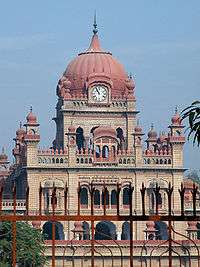
Maharaja Ranjit Singh's Ram Bagh Gardens
-

Golden Temple's Clock Tower
-

Durgiana Temple
-

Jallianwala Bagh
-
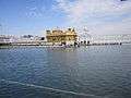
The holy water
-

Akal Takhat Sahib, Sikh Gurdwara
-

The holy water
-

Deorhi, main entrance to the summer palace of Maharaja Ranjit Singh, Ram Bagh, Amritsar
-
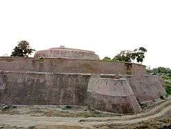
Gobindgarh fort, Amritsar,Punjab ,India
See also
References
- 1 2 3 4 5 6 7 "Provisional Population Totals, Census of India 2011; Cities having population 1 lakh and above" (PDF). Office of the Registrar General & Census Commissioner, India. Retrieved 26 March 2012.
- 1 2 3 "Provisional Population Totals, Census of India 2011; Urban Agglomerations/Cities having population 1 lakh and above" (PDF). Office of the Registrar General & Census Commissioner, India. Retrieved 26 March 2012.
- ↑ http://www.censusindia.gov.in/2011census/C-01/DDW03C-01%20MDDS.XLS
- ↑ nimmi. "Ram Tirth Temple, Indian Ram Tirth Temple, Ram Tirth Temple in India".
- ↑ "Mamas turn sons into monkeys –LANGOOR WALA MELA IN AMRITSAR...". 1 October 2008.
- ↑ "Introduction". HRIDAY official website.
- ↑ "History, Harmandir Sahib, the Golden Temple, Amritsar". Amritsar Portal. Retrieved 29 November 2014.
- ↑ Proceedings of the Lucknow Session of the Indian National Congress, 1916, cited by Pasricha, Ashu (2008). The Political Thought of Annie Besant (Encyclopaedia of Eminent Thinkers, Vol. 25). Concept Publishing. p. 84. ISBN 8180695859.
- ↑ "Operation Bluestar, 20 Years On". Rediff.com. 6 June 1984. Retrieved 17 July 2012.
- ↑ Ahmad, Ishtiaq (1996). State, Nation, and Ethnicity in the Contemporary South Asia. Continuum International Publishing Group. p. 130. ISBN 1-85567-578-1.
- ↑ Praagh, David Van (2003). The Greater game: India's Race With Destiny and China. India: McGill-Queen's University Press (MQUP). ISBN 0-7735-1639-5.
- ↑ Gunjeet K. Sra (19 December 2008). "10 Political Disgraces". Indiatoday.digitaltoday.in. Retrieved 9 August 2009.
- ↑ Martha Crenshaw (1995). Terrorism in Context. Penn State Press. p. 385. ISBN 978-0-271-01015-1.
- ↑ Singh, Pritam (2008). Federalism, Nationalism and Development: India and the Punjab Economy. Routledge. pp. 44. ISBN 978-0-415-45666-1. Retrieved 29 July 2010.
- ↑ Kaur, Jaskaran; Crossette, Barbara (2006). Twenty years of impunity: the November 1984 pogroms of Sikhs in India (PDF) (2nd ed.). Portland, OR: Ensaaf. p. 16. ISBN 0-9787073-0-3.
- ↑ Westerlund, David (1996). Questioning The Secular State: The Worldwide Resurgence of Religion in Politics. C. Hurst & Co. p. 1276. ISBN 1-85065-241-4.
- ↑ Singh, Pritam (2008). Federalism, Nationalism and Development: India and the Punjab Economy. Routledge. p. 45. ISBN 978-0-415-45666-1. Retrieved 29 July 2010.
- ↑ "Falling Rain Genomics, Inc – Amritsar". Fallingrain.com. Retrieved 17 July 2012.
- ↑ "Amritsar". Imd.gov.in. Retrieved 17 July 2012.
- 1 2 "Extremes of India" (PDF). www.imdpune.gov.in.
- ↑ "Resumen synop".
- ↑ "Amritsar Climate Normals 1971–1990". National Oceanic and Atmospheric Administration. Retrieved 11 January 2014.
- ↑ "State-wise, District-wise List of Blocks with >40% but less than 50% SC population". Retrieved 12 July 2012.
- ↑ "Amritsar District Population Census 2011, Punjab literacy sex ratio and density".
- ↑ ORGI. "Census of India :Religion PCA".
- ↑ "Rail ride to Chandigarh from Delhi in 50 mins flat?". The Times of India. 4 April 2008.
- ↑ "Railways invites global bids for Delhi-Amritsar high speed route". The Times of India. 23 March 2008.
- ↑ "Speed machines: 13 states want Bullet Train". The Times of India. 6 April 2008.
- ↑ "The Tribune, Chandigarh, India – Punjab". Tribuneindia.com. Retrieved 17 July 2012.
- ↑ http://www.distancesbetween.com/bus/bus-tickets-from-amritsar-to-chandigarh/753
- ↑ "Amritsar BRTS".
- ↑ http://www.punjabtourism.in/forts.html
- ↑ "South/Southeast Asia Library – UC Berkeley Library".
- ↑ http://ocw.mit.edu/courses/global-studies-and-languages/21f-041-topics-in-south-asian-literature-and-culture-fall-2004/readings/
- ↑ "Twin town". Sandwell Metropolitan Borough Council. Retrieved 12 June 2016.
External links
| Wikivoyage has a travel guide for Amritsar. |
| Wikimedia Commons has media related to Amritsar. |
- Official Website of District of Amritsar
- Official Website of Amritsar Municipal Corporation
- Amritsar HRIDAY city
- Maharaja Ranjit Singh Panorama
- Places to visit in Amritsar
- Amritsar to Delhi Bus
| Topics |
|  |
|---|---|---|
| Regions | ||
| Districts | ||
| Major Cities | ||