Amphidromic point
An amphidromic point is a point of zero amplitude of one harmonic constituent of the tide.[1] The tidal range (the peak-to-peak amplitude, or height difference between high tide and low tide) for that harmonic constituent increases with distance from this point.[2] These points are sometimes called tidal nodes.
The term amphidromic point derives from the Greek words amphi (around) and dromos (running), referring to the rotary tides running around them.[3]
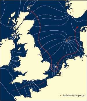
Amphidromic points occur because of the Coriolis effect and interference within oceanic basins, seas and bays creating a wave pattern — called an amphidromic system — which rotates around the amphidromic point.[2][5] At the amphidromic points of the dominant tidal constituent, there is almost no vertical movement from tidal action. There can be tidal currents since the water levels on either side of the amphidromic point are not the same. A separate amphidromic system is created by each periodic tidal component.[6]
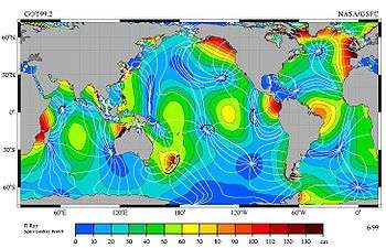
In most locations M2 is the largest (semidiurnal) tidal constituent, with an amplitude of roughly half of the full tidal range. Having cotidal points means they reach high tide at the same time and low tide at the same time. In the accompanying figure, the low tide lags or leads by 1 hr 2 min from its neighboring lines. Where the lines meet are amphidromes, and the tide rotates around them; for example, along the Chilean coast, and from southern Mexico to Peru, the tide propagates southward, while from Baja California to Alaska the tide propagates northward.
Amphidromic points in the M2 tidal constituent
Based on the accompanying figure, the set of clockwise amphidromic points includes:
- north of the Seychelles
- near Enderby Land
- off Perth
- east of New Guinea
- south of Easter Island
- west of the Galapagos Islands
- north of Queen Maud Land
Counterclockwise amphidromic points include:
- near Sri Lanka
- north of New Guinea
- at Tahiti
- between Mexico and Hawaii
- near the Leeward Islands
- east of Newfoundland
- midway between Rio de Janeiro and Angola
- east of Iceland
The islands of Madagascar and New Zealand are amphidromic points in the sense that the tide goes around them (counterclockwise in both cases) in about 12 and a half hours, but the amplitude of the tides on their coasts is in some places large.
See also
References and notes
- ↑ Desplanque, Con; Mossman, David J. (1 January 2004). "Tides and their seminal impact on the geology, geography, history, and socio-economics of the Bay of Fundy, eastern Canada". 40 (1). Retrieved 21 July 2016 – via journals.hil.unb.ca.
- 1 2 "Tides in two easy pieces - Earth 540: Essentials of Oceanography for Educators". Retrieved 21 July 2016.
- ↑ Cartwright, David Edgar (2000). Tides: A Scientific History. Cambridge University Press. p. 243. ISBN 978-0-521-79746-7.
- ↑ Picture credit: R. Ray, TOPEX/Poseidon: Revealing Hidden Tidal Energy GSFC, NASA. Redistribute with credit to R. Ray, as well as NASA-GSFC, NASA-JPL, Scientific Visualization Studio, and Television Production NASA-TV/GSFC
- ↑ http://www.salemstate.edu/~lhanson/gls214/gls214_tides.html
- ↑ "Untitled Document". Retrieved 21 July 2016.