American Border Peak
| American Border Peak | |
|---|---|
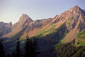 American Border Peak from Gold Run Pass | |
| Highest point | |
| Elevation | 7,998 ft (2,438 m) NAVD 88[1] |
| Prominence | 2,794 ft (852 m) [1] |
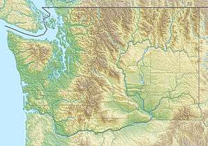
| Coordinates | 48°59′43″N 121°39′55″W / 48.9954056°N 121.66514°WCoordinates: 48°59′43″N 121°39′55″W / 48.9954056°N 121.66514°W [2] |
| Geography | |
 American Border Peak | |
| Parent range | North Cascades |
| Topo map | USGS Mt. Larrabee |
| Climbing | |
| First ascent | September 14, 1930 by Alec Dalgleish, Tom Fyles, Stan Henderson, R. A. Fraser[3] |
| Easiest route | Southeast face (Exposed scramble) |
American Border Peak is a mountain just south of the Canada–United States border, in the North Cascades of Washington state, with a corresponding sister peak, Canadian Border Peak, just north along a col connecting to it across the border.[4] It is located within the Mount Baker Wilderness, part of the Mount Baker-Snoqualmie National Forest, near North Cascades National Park. It is notable for its large, steep local relief; however its somewhat rotten rock makes it less appealing to climbers than nearby Slesse Mountain.[3]
Notes
- 1 2 "American Border Peak, Washington". Peakbagger.com. Retrieved 2011-05-26.
- ↑ "American Border Peak". Geographic Names Information System. United States Geological Survey. Retrieved 2008-10-18.
- 1 2 Beckey, Fred W. (2008). Cascade Alpine Guide, Vol. 3, Rainy Pass to Fraser River (3rd ed.). Mountaineers Books. pp. 53ff. ISBN 1-59485-136-0.
- ↑ "Canadian Border Peak". BC Geographical Names. Retrieved 2011-05-26.
External links
- Howbert, Jeff. "All Washington Peaks with 2000 Feet of Prominence". The Northwest Peakbaggers Asylum.
This article is issued from Wikipedia - version of the 8/21/2016. The text is available under the Creative Commons Attribution/Share Alike but additional terms may apply for the media files.