Amadiya
| Amadiya ܥܲܡܵܕܝܵܐ Amêdî, ئامێدی | |
|---|---|
|
Amadiya bird's eye view | |
| Nickname(s): ܥܲܡܵܕܝܵܐ | |
 Amadiya | |
| Coordinates: 37°05′33″N 43°29′14″E / 37.09250°N 43.48722°E | |
| Country |
|
| Autonomous region |
|
| Governorate | Dohuk Governorate |
| District | Amadiya District |
| Founded | Before 3000 B.C. |
| Elevation | 3,900 ft (1,200 m) |
| Population | |
| • Total | 6,000 |
| Time zone | GMT +3 |
| • Summer (DST) | GMT +3 (UTC) |
Amadiya (Kurdish: Amêdî, ئامێدی, Arabic: العمادية,Aramaic: ܥܲܡܵܕܝܵܐ Al-Emadiyah), is an Assyrian and Kurdish populated town and popular summer resort and Hill station along a tributary to the Great Zab in the Dahuk Governorate of Iraqi Kurdistan.[1] The city is situated 4,600 feet (1,400 m) above sea level.
History
The history of the city of Amadiya can be traced as far back as ancient Assyria, and it has probably existed even prior to that due to its strategic place on the flat top of a mountain.[2][3] Nevertheless, Amadiya was an Ancient Assyrian city known as Amedi from the 25th century BC until the end of the 7th century BC with the fall of the Assyrian Empire. After that, it was part of Achaemenid Assyria, Seleucid Assyria, the Roman province of Assyria and Parthian and Sassanid ruled Assyria (Athura/Assuristan) until its dissolution in the mid 7th century AD after the rise of Islam and the regions conquest by the Arabs.[4] Then, For several centuries, after the expulsion of the caliphs from Baghdad in the 7th century, it was ruled by a pasha from the royal Abbas family, reputed to be one of the richest families in the region.[5]
Additionally, The region in which the city rests is also believed to have been the seat of the Magi, or high priests of Persian-ruled Assyria. Therefore, the city is also believed to be the home of some of the most significant Magi priests: the Biblical Magi or the "Three Wise Men" who made a pilgrimage to Jerusalem to see Jesus Christ shortly after his birth.[6]
Amadiya was the birthplace of the pseudo-Messiah, David Alroy (fl. 1160). In 1163, according to Joseph ha-Kohen's "'Emeḳ ha-Baka", the Jewish population numbered about a thousand families and traded in gall-nuts. Alroy led a revolt against the city but was apparently defeated and killed in the process.[7] The Spanish Jewish historian R. Schlomo Ibn Verga (1450–1525) portrayed the Jewish community of Amadiya at the time of Alroy as wealthy and contented.[8]
Amadiya was the seat of the semi-autonomous Badinan Emirate, which lasted from 1376 to 1843. At the turn of the 19th century, the population already numbered 6,000, of whom 2,500 were Kurds, 1,900 Jews and 1,600 Assyrians. There are ruins from the Assyrian era and ruins of a synagogue and a church in the small town.[9] The city also has an ancient mosque and a church.[10][11]
Geography
The town is perched on a mountain, formerly only accessible by a narrow stairway cut into the rock. Amedia has a well-integrated community of Christian Assyrians and Muslim Kurds that share the city and local social events.[10]
Although Amedia is just 10 1⁄2 miles (16.9 km) from the Turkish border across the Beshesh Mountains, the only border crossing into Turkey is now at Ibrahim Khalil border on the road Amedia - Dohuk - Zakho, 56 miles (90 km) away. There was formerly a border crossing at Habur.
The region north of the mountainous region on the border with Turkey and all poplar, willow and oak, hawthorn, Cherry plum, rose hips, mountain apple, pear, Sorbus and so on wild trees and meadow grasses are usually located in. The town is 1,100 yards (1,000 m) long and 550 yards (500 m) wide. It houses 6,000 citizens in almost 1,200 houses.
Climate
| Climate data for Amadiya | |||||||||||||
|---|---|---|---|---|---|---|---|---|---|---|---|---|---|
| Month | Jan | Feb | Mar | Apr | May | Jun | Jul | Aug | Sep | Oct | Nov | Dec | Year |
| Average high °C (°F) | 8 (46) |
10 (50) |
15 (59) |
21 (70) |
27 (81) |
31 (88) |
33 (91) |
27 (81) |
23 (73) |
20 (68) |
13 (55) |
10 (50) |
19.8 (67.7) |
| Average low °C (°F) | 2 (36) |
3 (37) |
8 (46) |
12 (54) |
17 (63) |
19 (66) |
23 (73) |
22 (72) |
17 (63) |
14 (57) |
8 (46) |
4 (39) |
12.4 (54.3) |
| Average precipitation mm (inches) | 39 (1.54) |
75 (2.95) |
57 (2.24) |
45 (1.77) |
21 (0.83) |
trace | 0 (0) |
0 (0) |
trace | 21 (0.83) |
60 (2.36) |
72 (2.83) |
390 (15.35) |
| Average precipitation days | 7 | 6 | 10 | 8 | 4 | 1 | 0 | 0 | 1 | 7 | 7 | 10 | 61 |
| Source: [12] | |||||||||||||
Gallery
-

The picturesque town and capital of the district, Amadiya, Iraqi Kurdistan
-

Citadel of Al Amadiya
-

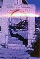
The Badinan Gate, and the entrance to the Citadel
-
-

-

References
| Wikivoyage has a travel guide for Amedi. |
- ↑ Naval Intelligence Division (1944). Iraq and the Persian Gulf. Geographical Handbook Series. OCLC 1077604.
- ↑ Karen Dabrowska; Geoff Hann (2008). Iraq Then and Now: A Guide to the Country and Its People. Bradt Travel Guides. pp. 177–. ISBN 978-1-84162-243-9.
- ↑ http://www.theotheriraqtours.com/place/amadiya
- ↑ http://www.livius.org/li-ln/limmu/limmu_1c.html
- ↑ Wright, George Newenham (1834). A New and Comprehensive gazetteer, Volume 1. T. Kelly. Retrieved 2009-09-12.
- ↑ Bailey, Betty Jane. Who are the Christians in the Middle East? Wm. B. Eerdmans Publishing Company (May 2003)
- ↑ "Jewish Encyclopedia". 1906. Retrieved 2009-09-12.
- ↑ Lenowitz, Harris (1906). The Jewish Messiahs: From the Galilee to Crown Heights. Retrieved 2009-09-12.
- ↑ "Catholic Encyclopaedia". Appleton. 1907. Retrieved 2009-09-12.
- 1 2 http://www.joaoleitao.com/driving/road-trip-northern-iraq/
- ↑ pictures of church- http://www.ishtartv.com/en/viewarticle,35634.html
- ↑ "Weather averages for Amadiya". World Weather Online. Retrieved September 6, 2014.