Alva, Oklahoma
| Alva, Oklahoma | |
|---|---|
| City | |
 | |
 Location of Alva within Oklahoma | |
| Coordinates: 36°48′21″N 98°40′04″W / 36.80583°N 98.66778°WCoordinates: 36°48′21″N 98°40′04″W / 36.80583°N 98.66778°W | |
| Country | United States |
| State | Oklahoma |
| County | Woods |
| Incorporated | 1893 |
| Government[1] | |
| • Type | Council-manager |
| • Mayor | Mayor Kelly Parker |
| • City manager | Joe Don Dunham |
| Area | |
| • Total | 2.389121 sq mi (6.187795 km2) |
| • Land | 2.389121 sq mi (6.187795 km2) |
| • Water | 0.0 sq mi (0.0 km2) |
| Elevation | 1,348 ft (411 m) |
| Population (2010)[2] | |
| • Total | 4,945 |
| • Density | 2,100/sq mi (800/km2) |
| Time zone | Central (CST) (UTC-6) |
| • Summer (DST) | CDT (UTC-5) |
| ZIP code | 73717 |
| Area code(s) | 580 |
| FIPS code | 40-01800[3] |
| GNIS feature ID | 1089605[4] |
| Website | alvaok.org |
Alva is a city in and the county seat of Woods County, Oklahoma, United States,[5] along the Salt Fork Arkansas River. The population was 4,945 at the 2010 census.[2] Northwestern Oklahoma State University is located in Alva.[6]
History
Alva was established in 1893 as a land office for the Cherokee Outlet land run, the largest of the land rushes that settled western and central Oklahoma. The site was chosen for its location on the Atchison, Topeka & Santa Fe Railway and likely named for a railroad attorney, Alva Adams, who had become governor of Colorado.
When the Southern Kansas Railway, began extending its line from Kiowa, Kansas across the Cherokee Outlet in 1886, Alva became the first railroad station southwest of Kiowa. The line was operational in 1887, in time for the opening of the Unassigned Lands.[6]
The Secretary of the Interior chose Alva as the seat of County M when Oklahoma Territory was organized in 1890. A U.S. government land office opened there before a presidential proclamation on August 19, 1893, opened the Cherokee Outlet for general settlement . The actual land run occurred September 16, 1893. By then, Alva's 320 acres (1.3 km2) site had been formally surveyed and platted.[6]
Northwestern Territorial Normal School now Northwestern Oklahoma State University, was established in 1897 in Alva by the Territorial Legislature.[6]
During World War II, Alva was the site of a prisoner of war camp for German POWs. On July 19, 1943, the United States Department of War ordered that Camp Alva would be the place for the internment of the most troublesome German prisoners of war – "Nazi leaders, Gestapo agents, and extremists".[7]
Today, the city council is actively soliciting murals and trying to attract businesses and tourists to keep people in town. Alva lost 200 people between 1990 and 2000 according to official census figures. The Alva Review-Courier is published Sunday, Wednesday, and Friday.
Alva is also the location of the Oklahoma Department of Corrections minimum-security Charles E. Johnson Correctional Center housing 630 male felon drug offenders.[8]
Geography
Alva is located in the northeastern quadrant of Woods County, Oklahoma, 65 miles (105 km) northeast of Woodward, Oklahoma, 72 miles (116 km) northwest of Enid, Oklahoma and 119 miles (192 km) southwest of Wichita, Kansas.[6] Its geographic coordinates are 36°48′7″N 98°39′57″W / 36.80194°N 98.66583°W (36.801931, −98.665959).[9] According to the United States Census Bureau, the city has a total area of 2.4 square miles (6.2 km2), all land.
Climate
| Climate data for Alva, Oklahoma | |||||||||||||
|---|---|---|---|---|---|---|---|---|---|---|---|---|---|
| Month | Jan | Feb | Mar | Apr | May | Jun | Jul | Aug | Sep | Oct | Nov | Dec | Year |
| Record high °F (°C) | 85 (29) |
89 (32) |
99 (37) |
100 (38) |
106 (41) |
114 (46) |
120 (49) |
118 (48) |
115 (46) |
103 (39) |
92 (33) |
85 (29) |
120 (49) |
| Average high °F (°C) | 48 (9) |
53 (12) |
62 (17) |
72 (22) |
80 (27) |
91 (33) |
96 (36) |
96 (36) |
88 (31) |
76 (24) |
61 (16) |
50 (10) |
72.8 (22.8) |
| Average low °F (°C) | 23 (−5) |
26 (−3) |
34 (1) |
45 (7) |
54 (12) |
64 (18) |
69 (21) |
68 (20) |
60 (16) |
48 (9) |
34 (1) |
31 (−1) |
46.3 (8) |
| Record low °F (°C) | −15 (−26) |
−16 (−27) |
−5 (−21) |
16 (−9) |
25 (−4) |
41 (5) |
51 (11) |
45 (7) |
31 (−1) |
10 (−12) |
5 (−15) |
−10 (−23) |
−16 (−27) |
| Average precipitation inches (mm) | 0.9 (23) |
1.2 (30) |
1.6 (41) |
2.6 (66) |
4.1 (104) |
3.7 (94) |
2.5 (64) |
3.1 (79) |
2.8 (71) |
2.2 (56) |
1.5 (38) |
1.0 (25) |
27.3 (693) |
| Average snowfall inches (cm) | 3.5 (8.9) |
4.8 (12.2) |
3.2 (8.1) |
0.2 (0.5) |
0 (0) |
0 (0) |
0 (0) |
0 (0) |
0 (0) |
0 (0) |
1.1 (2.8) |
3.3 (8.4) |
16.1 (40.9) |
| Source: Weatherbase[10] | |||||||||||||
Demographics
| Historical population | |||
|---|---|---|---|
| Census | Pop. | %± | |
| 1900 | 1,499 | — | |
| 1910 | 3,688 | 146.0% | |
| 1920 | 3,913 | 6.1% | |
| 1930 | 5,121 | 30.9% | |
| 1940 | 5,055 | −1.3% | |
| 1950 | 6,505 | 28.7% | |
| 1960 | 6,258 | −3.8% | |
| 1970 | 7,440 | 18.9% | |
| 1980 | 6,416 | −13.8% | |
| 1990 | 5,495 | −14.4% | |
| 2000 | 5,288 | −3.8% | |
| 2010 | 4,945 | −6.5% | |
| Est. 2015 | 5,180 | [11] | 4.8% |
| U.S. Decennial Census | |||
2010 census
As of the census of 2010, there were 4,945 people, 2,107 households, 1,134 families residing in the city.[2] The population density was 2,100 people per square mile (800/km²). There were 2,568 housing units at an average density of 1,110 per square mile (425/km²).[2] Self-identified white residents made up 90% of the population, with the remainder composed of 2% African American, 2.1% Native American, 1.1% Asian, less than 0.1% Pacific Islander, 2% from other races, and 2.7% from two or more races. Hispanic or Latino of any race were 4.6% of the population.
Of the 2,107 households, a quarter (24.9%) included individuals under the age of 18, 40.8% were married couples, 13.1% had a householder with no spouse present, and 46.2% were non-families. More than a third of households (36%) consisted of a single individual. Less than a quarter (13.2%) consisted of an individual age 65 or older living alone. The average household size was 2.17. The average family size was 2.86.
2000 census
As of the census[3] of 2000, there were 5,288 people, 2,205 households, and 1,261 families residing in the city. The population density was 2,228.6 people per square mile (861.5/km²). There were 2,644 housing units at an average density of 1,114.3 per square mile (430.7/km²). The racial makeup of the city was 94.99% White, 1.30% African American, 1.34% Native American, 0.78% Asian, 0.04% Pacific Islander, 0.23% from other races, and 1.32% from two or more races. Hispanic or Latino of any race were 1.82% of the population.
There were 2,205 households out of which 23.9% had children under the age of 18 living with them, 46.1% were married couples living together, 8.4% had a female householder with no husband present, and 42.8% were non-families. 34.7% of all households were made up of individuals and 16.0% had someone living alone who was 65 years of age or older. The average household size was 2.16 and the average family size was 2.81.
In the city the population was spread out with 18.9% under the age of 18, 21.7% from 18 to 24, 20.5% from 25 to 44, 18.9% from 45 to 64, and 20.0% who were 65 years of age or older. The median age was 35 years. For every 100 females there were 93.8 males. For every 100 females age 18 and over, there were 88.5 males.
The median income for a household in the city was $27,432, and the median income for a family was $38,041. Males had a median income of $27,531 versus $17,981 for females. The per capita income for the city was $17,966. About 9.1% of families and 17.1% of the population were below the poverty line, including 13.8% of those under age 18 and 7.0% of those age 65 or over.
Education
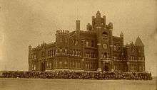
Alva is home to Northwestern Oklahoma State University (NWOSU), founded in 1897 as a normal school.[6] The college's main building for a time was the "Castle on the Hill," a huge, fanciful brick building, modeled after a Norman castle, that towered over much of the town. The Castle burned down in 1935, to be replaced by Jesse Dunn Hall, which was dedicated in 1937 by Eleanor Roosevelt.[12]
Northwest Technology Center is based in Alva. The Alva Independent School District oversees the public schools in the Alva area.
Economy
Agriculture has been the basis of the city's economy since it was founded. Initially, the local farms produced a variety of crops and livestock. The original 160-acre farms have mostly been consolidated into much larger units, concentrating on production of beef and wheat.[6]
NWOSU is the largest employer in Alva.[6]
Government
Alva has an aldermanic form of government.[6]
Transportation
U.S. Route 64 runs east-west through the center of the city, intersecting U.S. Route 281 which runs north-south. U.S. Route 281 joins U.S. Route 64 for one mile between College Boulevard (west) and Lane Boulevard (east) on Oklahoma Boulevard.[13]
Alva Regional Airport, a 650-acre general aviation facility owned and operated by the city, is immediately south of the city on the west side of U.S. Route 281.[13]
Alva is located on the Panhandle Subdivision of the Southern Transcon route of the BNSF Railway. This is the main transcontinental route between Los Angeles and Chicago, and carries an average of 90 freight trains per day. In January 2015 BNSF Railway announced an expansion project to add a second track between Wellington, Kansas and Avard, Oklahoma passing through Alva as part of a $175 million expansion in the South Region. Work on the project will start by 2016 and is expected to be completed by 2017.[14][15]
Notable people
- Scott Case, former NFL player.
- Lex Frieden, disability activist, was born in Alva.
- Mitchell Gale, current quarterback for the Saskatchewan Roughriders, was born in Alva and graduated from Alva High School.
- Jack Ging, actor, was born in Alva.
- Joe L. Heaton, United States federal judge seated on the United States District Court for the Western District of Oklahoma, was born in Alva.
- Hugh Johnson, Army officer, businessman, speech writer, government official, newspaper columnist, graduated from Alva High School in 1897.[16]
- Marilyn Mason, concert organist, was born in Alva.
- Herbert D. Smith, former member of Oklahoma House of Representatives elected in 1954, was born in Alva.
- Randy Terrill, former member of Oklahoma House of Representatives, was born in Alva.
In popular culture
- Don Draper spends most of the penultimate episode of the Mad Men series, "The Milk and Honey Route", in Alva.[17]
See also
- National Register of Historic Places listings in Woods County, Oklahoma
- Northwestern Oklahoma State University
- Northwest Technology Center
- Alva Regional Airport
References
- ↑ "Alva City Mayor". Retrieved May 26, 2015.
- 1 2 3 4 "2010 City Population and Housing Occupancy Status". U.S. Census Bureau. Archived from the original on July 21, 2011. Retrieved October 18, 2013.
- 1 2 "American FactFinder". United States Census Bureau. Archived from the original on September 11, 2013. Retrieved 2008-01-31.
- ↑ "US Board on Geographic Names". United States Geological Survey. October 25, 2007. Retrieved 2008-01-31.
- ↑ "Find a County". National Association of Counties. Archived from the original on May 31, 2011. Retrieved 2011-06-07.
- 1 2 3 4 5 6 7 8 9 Reichenberger, Donovan. "Alva," Encyclopedia of Oklahoma History and Culture. Accessed June 21, 2010.
- ↑ Hurt, R. Douglas (2008). The Great Plains During World War II. U of Nebraska Press. ISBN 9780803224094. Retrieved April 6, 2014.
- ↑ "Charles E. "Bill" Johnson Correctional Center". Oklahoma Department of Corrections. Archived from the original on June 19, 2015. Retrieved July 26, 2015.
- ↑ "US Gazetteer files: 2010, 2000, and 1990". United States Census Bureau. February 12, 2011. Retrieved 2011-04-23.
- ↑ "Weatherbase: Historical Weather for Alva, Oklahoma, United States".
- ↑ "Annual Estimates of the Resident Population for Incorporated Places: April 1, 2010 to July 1, 2015". Retrieved July 2, 2016.
- ↑ "Three buildings celebrating 70th year" (pdf). Northwestern Oklahoma State University. Retrieved June 28, 2015.
- 1 2 "Department of Transportation 2015–2016 Official State Map" (PDF). ODOT. Oklahoma Department of Transportation. Retrieved June 28, 2015.
- ↑ Casas, Amy. "BNSF Invests Across its Regions to Expand Capacity and Maintain Vast Network". reuters.com. Retrieved June 28, 2015.
- ↑ Miller, Jessica. "BNSF plans include double tracking near, through Alva". enidnews.com. The Enid News and Eagle. Retrieved June 28, 2015.
- ↑ Reichenberger, Donovan. Encyclopedia of Oklahoma History and Culture. "Woods County." Retrieved January 1, 2013.
- ↑ "Review of Mad Men: "The Milk and Honey Route"". AV Club. May 10, 2015.
External links
| Wikimedia Commons has media related to Alva, Oklahoma. |
Municipalities and communities of Woods County, Oklahoma, United States | ||
|---|---|---|
| Cities |  | |
| Towns | ||
| Unincorporated communities | ||