Alpamayo
| Alpamayo | |
|---|---|
| Allpamayu / Shuyturaju | |
 Two groups of climbers on Alpamayo SW face | |
| Highest point | |
| Elevation | 5,947 m (19,511 ft) |
| Coordinates | 08°52.75′S 77°39.22′W / 8.87917°S 77.65367°WCoordinates: 08°52.75′S 77°39.22′W / 8.87917°S 77.65367°W |
| Naming | |
| Translation | Earth River (Quechua) |
| Geography | |
 Alpamayo Peru | |
| Location | Ancash, Peru |
| Parent range | Cordillera Blanca |
| Climbing | |
| First ascent | June 20, 1957, by Günter Hauser, Berhard Huhn and Horst Wiedmann. |
| Easiest route | Difficult snow/ice climb on SW face |
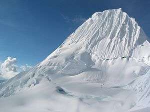
Alpamayo[1][2] (in Hispanicized spelling), Allpamayu (Quechua allpa earth, mayu river,[3] "earth river") or Shuyturaju (Ancash Quechua huytu, shuytu oblong, slim and long, Quechua rahu snow, ice, mountain with snow, "slim and long snow-covered mountain")[2][4][5] is one of the most conspicuous peaks in the Cordillera Blanca of the Peruvian Andes. It is named after Alpamayu creek, which originates northwest of it.[1]
It is a steep (sixty degrees), almost perfect pyramid of ice, one of a number of peaks that compose the Pukarahu massif, the northernmost massif of the Cordillera Blanca. Although smaller than many of its neighboring peaks, it is distinguished by its unusual formation and overwhelming beauty. It actually has two sharp summits, North and South, separated by a narrow corniced ridge.
In July 1966, the German magazine "Alpinismus", published a photo of Alpamayo taken by American photographer Leigh Ortenburger accompanied by an article on a survey among mountaineering experts, who chose Alpamayo as "The Most Beautiful Mountain in the World".[6]
Climbing history and routes
Most popular routes start from the village of Caraz, on the north of the Cordillera Blanca. A French-Belgian expedition including George and Claude Kogan claimed to have made the first ascent in 1951. After studying the photos in George Kogan's book The Ascent of Alpamayo, the German team of G. Hauser, F. Knauss, B. Huhn & H. Wiedmann came to the conclusion that the 1951 team did not reach the actual summit, thereby making their ascent via the north ridge in 1957 the first.
The most common climbing route, known as the Ferrari route, is situated on the southwest face of the mountain. It was opened in 1975 by a group of Italian alpinists led by Casimiro Ferrari. It is considered a difficult climb, demanding good crampon and ice-climbing technique. There are incomparable views of steep ice faces, penitentes, gigantic white walls and ridges like those of Huandoy Norte, Artesonraju and Huascaran Norte, similar to the finest of the Himalayan scenery. There are also at least six other alternative climbing routes, the second most popular being the Vasque-French route.
References
- 1 2 Peru 1:100 000, Corongo (18-h). IGN (Instituto Geográfico Nacional - Perú).
Nevado Alpamayo
- 1 2 "Nevado Alpamayo". Inventario Turístico del Perú (in Spanish). MINCETUR. Retrieved 25 May 2016.
- ↑ Teofilo Laime Ajacopa, Diccionario Bilingüe Iskay simipi yuyayk'ancha, La Paz, 2007 (Quechua-Spanish dictionary)
- ↑ homepage.ntlworld.com/robert_beer Robert Beér, Armando Muyolemaj, Dr. Hernán S. Aguilarpaj, Vocabulario comparativo, quechua ecuatoriano - quechua ancashino - castellano - English, Brighton 2006
- ↑ babylon.com
- ↑ Hibbert, Ian (2015). Alpamayo to Everest: It’s Not About the Summit. Lulu Press. ISBN 9781483440736.
External links
| Wikimedia Commons has media related to Alpamayo. |
- Alpamayo on Summitpost
- Expedition to Alpamayo - numerous photographs
- (French) French Young Expedition to Alpamayo - photographs and good topo
- Landscapes of the Soul - An Australian climber's stunning photos of climbers on the Ferrari Route, and his 1987 ascent/descent of the more difficult French Route.
- Climbing Alpamayo 2007 ascent of the French Direct route, including many photographs