Allens Station, New Jersey
| Allens Station, New Jersey | |
|---|---|
| Unincorporated community | |
|
Site of the former railroad station | |
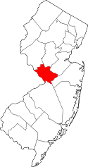
 Allens Station, New Jersey  Allens Station, New Jersey  Allens Station, New Jersey Location of Allens Station in Mercer County Inset: Location of county within the state of New Jersey | |
| Coordinates: 40°13′55″N 74°32′27″W / 40.23194°N 74.54083°WCoordinates: 40°13′55″N 74°32′27″W / 40.23194°N 74.54083°W | |
| Country |
|
| State |
|
| County | Mercer |
| Township | East Windsor and Robbinsville |
| Elevation[1] | 125 ft (38 m) |
| GNIS feature ID | 882978[1] |

Allens Station (also known simply as Allens[2]) is an unincorporated community located on the border of East Windsor and Robbinsville townships in Mercer County, New Jersey, United States.[3] The location is named for a former railroad station on the now-defunct Pemberton and Hightstown Railroad.[4][5]
References
- 1 2 "Allens Station". Geographic Names Information System. United States Geological Survey.
- ↑ Mercer County Atlas (Map). 1:24000. Hagstrom Map. 2004. p. 30. ISBN 0-88097-760-4.
- ↑ Locality Search, State of New Jersey. Accessed January 9, 2015.
- ↑ Mueller's Automobile Driving and Trolley Map of Mercer County, New Jersey (Map). A. H. Mueller. 1918. Retrieved January 17, 2015.
- ↑ Pennsylvania Railroad and Its Connections (Map). December 1, 1911. Retrieved January 17, 2015.
This article is issued from Wikipedia - version of the 6/8/2016. The text is available under the Creative Commons Attribution/Share Alike but additional terms may apply for the media files.