Allenc
| Allenc | |
|---|---|
|
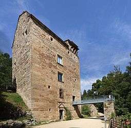
The tower of Villaret, in Allenc | |
 Allenc | |
|
Location within Occitanie region  Allenc | |
| Coordinates: 44°32′30″N 3°39′43″E / 44.5417°N 3.6619°ECoordinates: 44°32′30″N 3°39′43″E / 44.5417°N 3.6619°E | |
| Country | France |
| Region | Occitanie |
| Department | Lozère |
| Arrondissement | Mende |
| Canton | Le Bleymard |
| Intercommunality | Goulet-Mont Lozère |
| Government | |
| • Mayor (2008–2014) | Jacky Ferrier |
| Area1 | 38.58 km2 (14.90 sq mi) |
| Population (2009)2 | 247 |
| • Density | 6.4/km2 (17/sq mi) |
| Time zone | CET (UTC+1) |
| • Summer (DST) | CEST (UTC+2) |
| INSEE/Postal code | 48003 / 48190 |
| Elevation |
926–1,326 m (3,038–4,350 ft) (avg. 1,025 m or 3,363 ft) |
|
1 French Land Register data, which excludes lakes, ponds, glaciers > 1 km² (0.386 sq mi or 247 acres) and river estuaries. 2 Population without double counting: residents of multiple communes (e.g., students and military personnel) only counted once. | |
Allenc is a commune in the Lozère department in southern France.
Population
| Historical population | ||
|---|---|---|
| Year | Pop. | ±% |
| 1793 | 1,415 | — |
| 1800 | 1,549 | +9.5% |
| 1806 | 1,556 | +0.5% |
| 1821 | 1,382 | −11.2% |
| 1831 | 1,584 | +14.6% |
| 1836 | 1,706 | +7.7% |
| 1841 | 1,699 | −0.4% |
| 1846 | 1,652 | −2.8% |
| 1851 | 1,540 | −6.8% |
| 1856 | 778 | −49.5% |
| 1861 | 786 | +1.0% |
| 1866 | 825 | +5.0% |
| 1872 | 783 | −5.1% |
| 1876 | 780 | −0.4% |
| 1881 | 756 | −3.1% |
| 1886 | 803 | +6.2% |
| 1891 | 751 | −6.5% |
| 1896 | 1,017 | +35.4% |
| 1901 | 759 | −25.4% |
| 1906 | 763 | +0.5% |
| 1911 | 699 | −8.4% |
| 1921 | 581 | −16.9% |
| 1926 | 564 | −2.9% |
| 1931 | 561 | −0.5% |
| 1936 | 491 | −12.5% |
| 1946 | 514 | +4.7% |
| 1954 | 398 | −22.6% |
| 1962 | 353 | −11.3% |
| 1968 | 291 | −17.6% |
| 1975 | 237 | −18.6% |
| 1982 | 209 | −11.8% |
| 1990 | 176 | −15.8% |
| 1999 | 189 | +7.4% |
| 2007 | 237 | +25.4% |
| 2009 | 247 | +4.2% |
See also
References
External links
| Wikimedia Commons has media related to Allenc. |
This article is issued from Wikipedia - version of the 2/11/2016. The text is available under the Creative Commons Attribution/Share Alike but additional terms may apply for the media files.