Aliquippa, Pennsylvania
| Aliquippa, Pennsylvania | |
|---|---|
| City | |
|
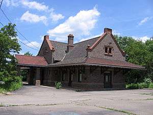
Franklin Avenue downtown | |
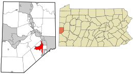 Location in Beaver County and state of Pennsylvania | |
| Coordinates: 40°36′54″N 80°15′47″W / 40.61500°N 80.26306°WCoordinates: 40°36′54″N 80°15′47″W / 40.61500°N 80.26306°W | |
| Country | United States |
| State | Pennsylvania |
| County | Beaver |
| Settled | 1793 |
| Incorporated | 1894 |
| 1928 (borough) | |
| 1987 (city) | |
| Government | |
| • Type | City Council |
| Area | |
| • Total | 4.5 sq mi (11.6 km2) |
| • Land | 4.1 sq mi (10.6 km2) |
| • Water | 0.4 sq mi (1.0 km2) |
| Elevation | 850 ft (260 m) |
| Population (2010) | |
| • Total | 9,438 |
| • Density | 2,867.7/sq mi (1,107.7/km2) |
| Time zone | Eastern (EST) (UTC-5) |
| • Summer (DST) | EDT (UTC-4) |
| Zip code | 15001 |
| Website | City of Aliquippa website |

Aliquippa is a city in Beaver County in the U.S. state of Pennsylvania; it is within the Pittsburgh Metropolitan Statistical Area. The population was 9,438 at the 2010 census. Formerly the Borough of Aliquippa, it was formally named a city in 1987 by the Aliquippa Borough Council.
History
Aliquippa was founded by the merger of three towns: Aliquippa, Woodlawn, and New Sheffield.[1] There is no evidence connecting the Seneca Queen Aliquippa with the location of the borough. This was one of several Indian names selected arbitrarily by the Pittsburgh and Lake Erie Railroad in 1878 for stations along the route.[1] Aliquippa is best known as the location of a productive steel mill that the Jones and Laughlin Steel Company constructed there along the Ohio River beginning in 1905. Employment at the facility sustained a population of 27,023 in 1940.[1]
The mill closed during the collapse of the steel industry during the 1980s. This major economic loss alongside suburbanization caused a major population loss through the end of the 20th century. The oldest church within the current boundaries of Aliquippa is Mt. Carmel Presbyterian Church (formerly White Oak Flats Presbyterian Church), established about 1793 in the New Sheffield region on Brodhead Road.[1] Many of the city's businesses have left since the closing of the mill. This has left the city economically depressed, with the crime rate dramatically rising over time.
The B.F. Jones Memorial Library is a historical landmark of the community.
Demographics
| Historical population | |||
|---|---|---|---|
| Census | Pop. | %± | |
| 1900 | 620 | — | |
| 1910 | 1,743 | 181.1% | |
| 1920 | 2,931 | 68.2% | |
| 1930 | 27,116 | 825.1% | |
| 1940 | 27,023 | −0.3% | |
| 1950 | 26,132 | −3.3% | |
| 1960 | 26,369 | 0.9% | |
| 1970 | 22,277 | −15.5% | |
| 1980 | 17,094 | −23.3% | |
| 1990 | 13,374 | −21.8% | |
| 2000 | 11,734 | −12.3% | |
| 2010 | 9,438 | −19.6% | |
| Est. 2015 | 9,197 | [2] | −2.6% |
| Sources:[3][4][5][6][7] | |||
As of the 2010 census, the city had 9,438 people. The city was 57.6% White, 38.6% Black or African American, 0.1% Native American, 0.4% Asian, and 2.8% were two or more races. 1.3% of the population was of Hispanic or Latino ancestry.[8]
As of the census[6] of 2000, there were 11,734 people, 5,124 households, and 3,176 families residing in the city. The population density was 2,867.7 people per square mile (1,107.7/km²). There were 5,843 housing units at an average density of 1,428.0 per square mile (551.6/km²). The racial makeup of the city was 62.59% White, 35.52% African American, 0.07% Native American, 0.18% Asian, 0.03% Pacific Islander, 0.18% from other races, and 1.43% from two or more races. Hispanic or Latino of any race were 1.00% of the population.
There were 5,124 households, out of which 24.4% had children under the age of 18 living with them, 35.7% were married couples living together, 21.6% had a female householder with no husband present, and 38.0% were non-families. 35.0% of all households were made up of individuals, and 17.1% had someone living alone who was 65 years of age or older. The average household size was 2.27 and the average family size was 2.92.
In the city the population was spread out, with 23.5% under the age of 18, 7.6% from 18 to 24, 25.5% from 25 to 44, 20.9% from 45 to 64, and 22.5% who were 65 years of age or older. The median age was 40 years. For every 100 females there were 82.7 males. For every 100 females age 18 and over, there were 77.2 males.
The median income for a household in the city was $25,113, and the median income for a family was $34,003. Males had a median income of $27,954 versus $21,358 for females. The per capita income for the city was $13,718. About 17.7% of families and 21.7% of the population were below the poverty line, including 36.3% of those under age 18 and 10.9% of those age 65 or over.
Notable people
- Paul Posluszny, NFL player
- Gust Avrakotos, Central Intelligence Agency operative
- Jonathan Baldwin, NFL player
- Tommie Campbell, NFL player
- Daniel Chamovitz, noted biologist and author of What a Plant Knows
- Mike Ditka, Pro Football Hall of Fame player and coach
- Tony Dorsett, Pro Football Hall of Fame player
- Kevin Budkey, Comedian, designer, entrepreneur
- Kenny Easterday, star of the Canadian movie "Kenny" (1988)
- Ivor Parry Evans, base commander, Walker AFB
- Tito Francona, Major League Baseball player
- Sean Gilbert, NFL player
- Frank Gnup, Canadian football player and coach
- Nate Guenin, National Hockey League player
- Frank Hribar, NFL player
- Ty Law, NFL player
- Joe Letteri, award-winning visual imaging artist
- Henry Mancini, Grammy and Oscar-winning music composer (Moon River and The Pink Panther Theme), born in Cleveland, raised in Aliquippa
- Pete Maravich, Basketball Hall of Fame player
- Press Maravich, basketball coach
- Demetria Martinez, poet and author
- Felicia Mason, author
- Doc Medich, Major League Baseball pitcher
- Darrelle Revis, NFL player
- Curt Singer, NFL player
- Jesse Steinfeld, Surgeon General of the United States
- Pete Suder, Major League Baseball player
Education
The city's residents are served by the Aliquippa School District. Children may also choose to attend a public charter school: Beaver Area Academic Charter School, Lincoln Park Performing Arts Charter School or the Pennsylvania Cyber Charter School a statewide public charter school which is based in Midland, Pennsylvania.[9]
Private schools
- Bethel Christian School
- Hope Christian Academy
- Sylvania Hills Christian
See also
References
- 1 2 3 4 "Aliquippa". Beaver County Bicentennial Atlas. 2002. Retrieved July 25, 2012.
- ↑ "Annual Estimates of the Resident Population for Incorporated Places: April 1, 2010 to July 1, 2015". Retrieved July 2, 2016.
- ↑ 1940 US Census
- ↑ 1960 US Census
- ↑ 1990 US Census
- 1 2 "American FactFinder". United States Census Bureau. Archived from the original on September 11, 2013. Retrieved January 31, 2008.
- ↑ "Annual Estimates of the Resident Population". U.S. Census Bureau. Retrieved November 22, 2013.
- ↑ USA Today Census profile
- ↑ Pennsylvania Department of Education, EdNA - Beaver County Schools, April 2011
- Feature in Sports Illustrated in January 2011, http://sportsillustrated.cnn.com/vault/article/magazine/MAG1181210/index.htm
External links
| Counties |  Map of the Pittsburgh Tri-State with green counties in the metropolitan area and yellow counties in the combined area. | |
|---|---|---|
| Major cities | ||
| Cities and towns 15k-50k (in 2010) | ||
| Airports | ||
| Topics | ||
| ||
Municipalities and communities of Beaver County, Pennsylvania, United States | ||
|---|---|---|
| Cities |  | |
| Boroughs |
| |
| Townships | ||
| Unincorporated communities | ||
| Footnotes | ‡This populated place also has portions in an adjacent county or counties | |