Alder, Washington
| Alder, Washington | |
|---|---|
| CDP | |
 Alder, Washington Location within the state of Washington | |
| Coordinates: 46°47′16″N 122°15′58″W / 46.78778°N 122.26611°WCoordinates: 46°47′16″N 122°15′58″W / 46.78778°N 122.26611°W | |
| Country | United States |
| State | Washington |
| County | Pierce |
| Area | |
| • Total | 3.24 sq mi (8.4 km2) |
| • Land | 3.21 sq mi (8.3 km2) |
| • Water | 0.03 sq mi (0.08 km2) |
| Elevation | 1,237 ft (377 m) |
| Population (2010)[1] | |
| • Total | 227 |
| Time zone | Pacific (PST) (UTC-8) |
| • Summer (DST) | PDT (UTC-7) |
| ZIP code | 98335 |
| Area code(s) | 360 |
Alder is a census-designated place (CDP) in Pierce County, Washington, United States. The population was 227 at the 2010 census. The community is located along the shore of Alder Lake on State Route Highway 7 near the entrance to Mount Rainier National Park.
A post office called Alder was established in 1902, and remained in operation until 1975.[2] The community was named for the alder trees near the original town site.[3]
Geography
Alder is located at 46°47′16″N 122°15′58″W / 46.78778°N 122.26611°W (46.787849, -122.26619).[4]
According to the United States Census Bureau, the CDP has a total area of 3.24 square miles (8.4 km²), of which, 3.21 square miles (8.3 km²) of it is land and 0.03 square miles (0.08 km²) of it (0.83%) is water.
References
- ↑ "American FactFinder". United States Census Bureau. Archived from the original on 2013-09-11. Retrieved 2015-05-25.
- ↑ "Post Offices". Jim Forte Postal History. Retrieved 12 July 2016.
- ↑ Meany, Edmond S. (1923). Origin of Washington geographic names. Seattle: University of Washington Press. p. 3.
- ↑ "US Gazetteer files: 2014". United States Census Bureau. Retrieved 2015-05-25.
Municipalities and communities of Pierce County, Washington, United States | ||
|---|---|---|
| Cities | 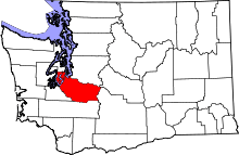 | |
| Towns | ||
| CDPs |
| |
| Other unincorporated communities | ||
| Indian reservation | ||
| Military bases | ||
| Ghost towns | ||
| Footnotes | ‡This populated place also has portions in an adjacent county or counties | |