Albuquerque, New Mexico
| Albuquerque, New Mexico | |||
|---|---|---|---|
| City | |||
|
| |||
| |||
| Nickname(s): ABQ, The Duke City, Burque, The 505, The Big A | |||
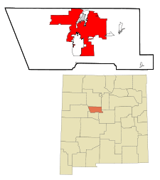 Location in the state of New Mexico | |||
 Albuquerque, New Mexico  Albuquerque, New Mexico Location in the contiguous United States | |||
| Coordinates: 35°06′39″N 106°36′36″W / 35.11083°N 106.61000°WCoordinates: 35°06′39″N 106°36′36″W / 35.11083°N 106.61000°W | |||
| Country |
| ||
| State |
| ||
| County | Bernalillo County | ||
| Founded | 1706 (as Alburquerque) | ||
| Incorporated | 1891 (as Albuquerque) | ||
| Government | |||
| • Type | Mayor-council government | ||
| • Mayor | Richard J. Berry (R)[1] | ||
| • City Council |
Councilors
| ||
| • State House |
Representatives
| ||
| • State Senate |
State senators
| ||
| • U.S. House |
Representative
| ||
| Area | |||
| • City | 189.5 sq mi (490.9 km2) | ||
| • Land | 187.7 sq mi (486.2 km2) | ||
| • Water | 1.8 sq mi (4.7 km2) | ||
| Elevation | 5,312 ft (1,619.1 m) | ||
| Population (2010)[2] | |||
| • City | 545,852 | ||
| • Estimate (2015) | 557,169[2] | ||
| • Rank | US: 32nd | ||
| • Density | 2,959/sq mi (1,142.3/km2) | ||
| • Metro |
907,301 (60th) 1,163,964 (Albuquerque–Santa Fe–Las Vegas CSA) | ||
| • Ethnicities[3] |
69.7% White 4.6% Multiracial 4.6% American Indian 3.3% Black 2.6% Asian 46.7% Hispanic | ||
| Demonym(s) |
Albuquerquean, Burqueño[4] | ||
| Time zone | MST (UTC-7) | ||
| • Summer (DST) | MDT (UTC-6) | ||
| ZIP code(s) |
87101–87125, 87131, 87151, 87153, 87154, 87158, 87174, 87176, 87181, 87184, 87185, 87187, 87190–87199 | ||
| Area code(s) | 505, 575 | ||
| FIPS code | 35-02000 | ||
| GNIS feature ID |
0928679 | ||
| Primary Airport |
Albuquerque International Sunport ABQ (Major/International) | ||
| Secondary Airport |
Double Eagle II Airport- KAEG (Public) | ||
| Website |
www | ||
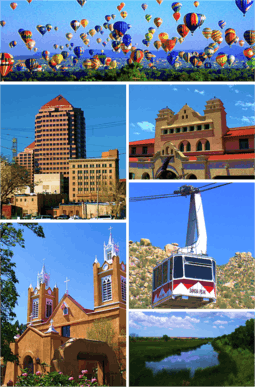
Albuquerque (![]() i/ˈælbəˌkɜːrki/ AL-bə-KURK-ee) is the most populous city in the U.S. state of New Mexico. The high-altitude city serves as the county seat of Bernalillo County,[5] and it is situated in the central part of the state, straddling the Rio Grande. The city population is 557,169 as of the July 1, 2014 population estimate from the United States Census Bureau,[2] and ranks as the 32nd-largest city in the U.S. The Albuquerque metropolitan statistical area (or MSA) has a population of 907,301 according to the United States Census Bureau's most recently available estimate for 2015.[6] Albuquerque is the 60th-largest United States metropolitan area. The Albuquerque MSA population includes the city of Rio Rancho, Bernalillo, Placitas, Corrales, Los Lunas, Belen, Bosque Farms, and forms part of the larger Albuquerque–Santa Fe–Las Vegas combined statistical area, with a total population of 1,163,964 as of the July 1, 2013 Census Bureau estimates.
i/ˈælbəˌkɜːrki/ AL-bə-KURK-ee) is the most populous city in the U.S. state of New Mexico. The high-altitude city serves as the county seat of Bernalillo County,[5] and it is situated in the central part of the state, straddling the Rio Grande. The city population is 557,169 as of the July 1, 2014 population estimate from the United States Census Bureau,[2] and ranks as the 32nd-largest city in the U.S. The Albuquerque metropolitan statistical area (or MSA) has a population of 907,301 according to the United States Census Bureau's most recently available estimate for 2015.[6] Albuquerque is the 60th-largest United States metropolitan area. The Albuquerque MSA population includes the city of Rio Rancho, Bernalillo, Placitas, Corrales, Los Lunas, Belen, Bosque Farms, and forms part of the larger Albuquerque–Santa Fe–Las Vegas combined statistical area, with a total population of 1,163,964 as of the July 1, 2013 Census Bureau estimates.
Albuquerque is home to the University of New Mexico (UNM), Kirtland Air Force Base, Sandia National Laboratories, the National Museum of Nuclear Science & History, Lovelace Respiratory Research Institute, Central New Mexico Community College (CNM), Presbyterian Health Services, and Petroglyph National Monument. The Sandia Mountains run along the eastern side of Albuquerque, and the Rio Grande flows through the city, north to south. Albuquerque is also the home of the International Balloon Fiesta, the world's largest such gathering of hot-air balloons from around the globe. The event takes place during the first week of October.
Etymology
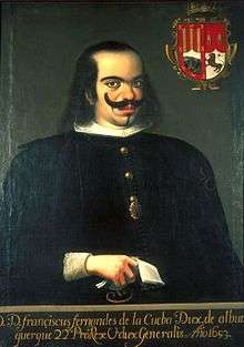
Albuquerque was named in honor of Francisco, Duke of Alburquerque,[7] who was viceroy of New Spain from 1653 to 1660.
The growing village soon to become Albuquerque was named by provincial governor Francisco Cuervo y Valdes. Francisco's title referred to the Spanish town of Alburquerque, in the Spanish province of Badajoz, near Portugal. The name has two theories of origin which denote either Latin or Arabic roots. The first of which derived from the Latin albus quercus meaning "white oak".[8] This name was probably in reference to the prevalence of cork oaks in the region, which have a white wood when the bark is removed. Alburquerque is still a center of the Spanish cork industry,[9] and the town coat-of-arms features a white cork oak.[10] Another theory suggests that it may come from the Arabic Abu al-Qurq, which means "father of the cork [oak]".
The first "r" in Alburquerque was later dropped, probably due to association with the prominent general Alfonso de Albuquerque, whose family title (among others), and then name, originated from the border Spanish town, but used a variant spelling in their name. The change was also in part due to the fact that citizens found the original name difficult to pronounce.[11]
Western folklore offers a different explanation, tracing the name Albuquerque to the Galician word albaricoque, meaning "apricot". The apricot was brought to New Mexico by Spanish settlers, possibly as early as 1743. As the story goes, the settlement was established near an apricot tree, and became known as La Ciudad de Albaricoque. As frontiersmen were unable to correctly pronounce the Galician word, it became corrupted to "Albuquerque".[12]
History
Early European settlers
Albuquerque was founded in 1706 as the Spanish colonial outpost of Villa de Alburquerque.[13] Present-day Albuquerque retains much of its historical Spanish cultural heritage.
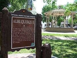
Albuquerque was a farming community and strategically located military outpost along the Camino Real. The town was also the sheep-herding center of the West.[14] Spain established a presidio (military garrison) in Albuquerque in 1706. After 1821, Mexico also had a military garrison there. The town of Alburquerque was built in the traditional Spanish village pattern: a central plaza surrounded by government buildings, homes, and a church. This central plaza area has been preserved and is open to the public as a museum, cultural area, and center of commerce. It is referred to as "Old Town Albuquerque" or simply "Old Town." Historically it was sometimes referred to as "La Placita" (little plaza in Spanish). On the north side of Old Town Plaza is San Felipe de Neri Church. Built in 1793, it is one of the oldest surviving buildings in the city.[15]
After the American occupation of New Mexico, Albuquerque had a federal garrison and quartermaster depot, the Post of Albuquerque, from 1846 to 1867. During the Civil War Albuquerque was occupied in February 1862 by Confederate troops under General Henry Hopkins Sibley, who soon afterward advanced with his main body into northern New Mexico. During his retreat from Union troops into Texas he made a stand on April 8, 1862, at Albuquerque and fought the Battle of Albuquerque against a detachment of Union soldiers commanded by Colonel Edward R. S. Canby. This daylong engagement at long range led to few casualties.
.jpg)
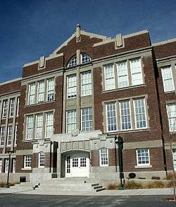
When the Atchison, Topeka and Santa Fe Railroad arrived in 1880, it bypassed the Plaza, locating the passenger depot and railyards about 2 miles (3 km) east in what quickly became known as New Albuquerque or New Town. Many Anglo merchants, mountain men, and settlers slowly filtered into Albuquerque creating a major mercantile commercial center which is now Downtown Albuquerque. Due to a rising rate of violent crime, gunman Milt Yarberry was appointed the town's first marshal that year. New Albuquerque was incorporated as a town in 1885, with Henry N. Jaffa its first mayor, and it was incorporated as a city in 1891.[16]:232–233 Old Town remained a separate community until the 1920s when it was absorbed by the city of Albuquerque. Old Albuquerque High School, the city's first public high school, was established in 1879. Congregation Albert, a Reform synagogue established in 1897, is the oldest continuing Jewish organization in the city.[17]
Early 20th century
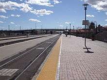
By 1900, Albuquerque boasted a population of 8,000 inhabitants and all the modern amenities, including an electric street railway connecting Old Town, New Town, and the recently established University of New Mexico campus on the East Mesa. In 1902, the famous Alvarado Hotel was built adjacent to the new passenger depot, and it remained a symbol of the city until it was razed in 1970 to make room for a parking lot. In 2002, the Alvarado Transportation Center was built on the site in a manner resembling the old landmark. The large metro station functions as the downtown headquarters for the city's transit department. It also serves as an intermodal hub for local buses, Greyhound buses, Amtrak passenger trains, and the Rail Runner commuter rail line.
New Mexico's dry climate brought many tuberculosis patients to the city in search of a cure during the early 20th century, and several sanitaria sprang up on the West Mesa to serve them. Presbyterian Hospital and St. Joseph Hospital, two of the largest hospitals in the Southwest, had their beginnings during this period. Influential New Deal–era governor Clyde Tingley and famed Southwestern architect John Gaw Meem were among those brought to New Mexico by tuberculosis.

Decades of growth


The first travelers on Route 66 appeared in Albuquerque in 1926, and before long, dozens of motels, restaurants, and gift shops had sprung up along the roadside to serve them. Route 66 originally ran through the city on a north-south alignment along Fourth Street, but in 1937 it was realigned along Central Avenue, a more direct east-west route. The intersection of Fourth and Central downtown was the principal crossroads of the city for decades. The majority of the surviving structures from the Route 66 era are on Central, though there are also some on Fourth. Signs between Bernalillo and Los Lunas along the old route now have brown, historical highway markers denoting it as Pre-1937 Route 66.
The establishment of Kirtland Air Force Base in 1939, Sandia Base in the early 1940s, and Sandia National Laboratories in 1949, would make Albuquerque a key player of the Atomic Age. Meanwhile, the city continued to expand outward onto the West Mesa, reaching a population of 201,189 by 1960. In 1990, it was 384,736 and in 2007 it was 518,271. In June 2007, Albuquerque was listed as the sixth fastest-growing city in America by CNN and the United States Census Bureau.[18] In 1990, the Census Bureau reported Albuquerque's population as 34.5% Hispanic and 58.3% non-Hispanic white.[19]
Albuquerque's downtown entered the same phase and development (decline, "urban renewal" with continued decline, and gentrification) as nearly every city across the United States. As Albuquerque spread outward, the downtown area fell into a decline. Many historic buildings were razed in the 1960s and 1970s to make way for new plazas, high-rises, and parking lots as part of the city's urban renewal phase. As of 2010, only recently has downtown come to regain much of its urban character, mainly through the construction of many new loft apartment buildings and the renovation of historic structures such as the KiMo Theater, in the gentrification phase.
New millennium
During the 21st century, the Albuquerque population has continued to grow rapidly. The population of the city proper was estimated at 528,497 in 2009, up from 448,607 in the 2000 census.[20] During 2005 and 2006, the city celebrated its tricentennial with a diverse program of cultural events.
Urban trends and issues
The passage of the Planned Growth Strategy in 2002–2004 was the community's strongest effort to create a framework for a more balanced and sustainable approach to urban growth.[21]
A critical finding of the study is that many of the 'disconnects' between the public's preferences and what actually is taking place are caused by weak or non-existent implementation tools – rather than by inadequate policies, as contained in the City/County Comprehensive Plan and other already adopted legislation.
Urban sprawl is limited on three sides—by the Sandia Pueblo to the north, the Isleta Pueblo and Kirtland Air Force Base to the south, and the Sandia Mountains to the east. Suburban growth continues at a strong pace to the west, beyond Petroglyph National Monument, once thought to be a natural boundary to sprawl development.[22]
Because of less-costly land and lower taxes, much of the growth in the metropolitan area is taking place outside of the city of Albuquerque itself. In Rio Rancho to the northwest, the communities east of the mountains, and the incorporated parts of Valencia County, population growth rates approach twice that of Albuquerque. The primary cities in Valencia County are Los Lunas and Belen, both of which are home to growing industrial complexes and new residential subdivisions. The mountain towns of Tijeras, Edgewood, and Moriarty, while close enough to Albuquerque to be considered suburbs, have experienced much less growth compared to Rio Rancho, Bernalillo, Los Lunas, and Belen. Limited water supply and rugged terrain are the main limiting factors for development in these towns. The Mid Region Council of Governments (MRCOG), which includes constituents from throughout the Albuquerque area, was formed to ensure that these governments along the middle Rio Grande would be able to meet the needs of their rapidly rising populations. MRCOG's cornerstone project is currently the New Mexico Rail Runner Express. In October 2013, the "Albuquerque Journal" reported Albuquerque as the third best city to own an investment property.[23]
Geography

According to the United States Census Bureau, Albuquerque has a total area of 189.5 square miles (490.9 km2), of which 187.7 square miles (486.2 km2) is land and 1.8 square miles (4.7 km2), or 0.96%, is water.[24]
Albuquerque lies within the northern, upper edges of the Chihuahuan Desert ecoregion, based on long-term patterns of climate, associations of plants and wildlife, and landforms, including drainage patterns.[25][26] Located in central New Mexico, the city also has noticeable influences from the adjacent Colorado Plateau semi-desert, Arizona–New Mexico Mountains, and Southwest plateaus and plains steppe ecoregions, depending on where one is located. Its main geographic connection lies with southern New Mexico, while culturally, Albuquerque is a crossroads of most of New Mexico.
Albuquerque has one of the highest elevations of any major city in the United States, though the effects of this are greatly tempered by its southwesterly continental position. The elevation of the city ranges from 4,900 feet (1,490 m) above sea level near the Rio Grande (in the Valley) to over 6,700 feet (1,950 m) in the foothill areas of Sandia Heights and Glenwood Hills. At the airport, the elevation is 5,352 feet (1,631 m) above sea level.
The Rio Grande is classified, like the Nile, as an "exotic" river because it flows through a desert. The New Mexico portion of the Rio Grande lies within the Rio Grande Rift Valley, bordered by a system of faults, including those that lifted up the adjacent Sandia and Manzano Mountains, while lowering the area where the life-sustaining Rio Grande now flows.
Geology

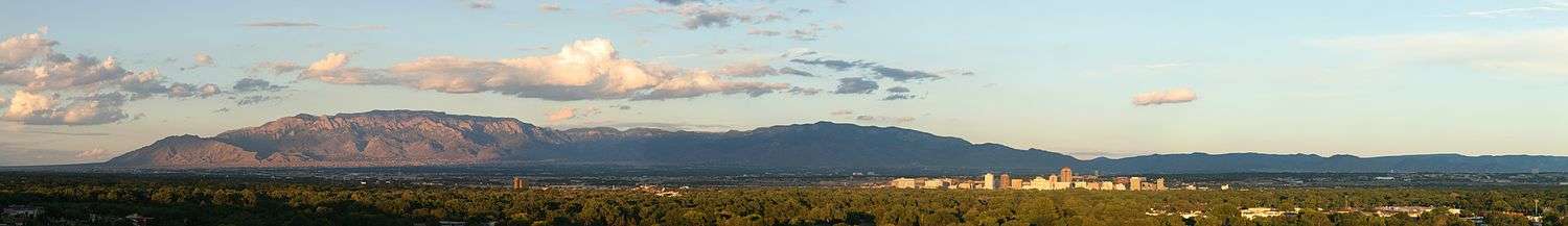
Albuquerque lies in the Albuquerque Basin, a portion of the Rio Grande rift.[27] The Sandia Mountains are the predominant geographic feature visible in Albuquerque. "Sandía" is Spanish for "watermelon", and is popularly believed to be a reference to the brilliant coloration of the mountains at sunset: bright pink (melon meat) and green (melon rind). The pink is due to large exposures of granodiorite cliffs, and the green is due to large swaths of conifer forests. However, Robert Julyan notes in The Place Names of New Mexico, "the most likely explanation is the one believed by the Sandia Pueblo Indians: the Spaniards, when they encountered the Pueblo in 1540, called it Sandia, because they thought the squash growing there were watermelons, and the name Sandia soon was transferred to the mountains east of the pueblo."[28] He also notes that the Sandia Pueblo Indians call the mountain Bien Mur, "big mountain."[28]
The Sandia foothills, on the west side of the mountains, have soils derived from that same rock material with varying sizes of decomposed granite, mixed with areas of clay and caliche (a calcium carbonate deposit common in the arid southwestern USA), along with some exposed granite bedrock.

Below the foothills, the area usually called the "Northeast Heights" consists of a mix of clay and caliche soils, overlaying a layer of decomposed granite, resulting from long-term outwash of that material from the adjacent mountains. This bajada is quite noticeable when driving into Albuquerque from the north or south, due to its fairly uniform slope from the mountains' edge downhill to the valley. Sand hills are scattered along the I-25 corridor and directly above the Rio Grande Valley, forming the lower end of the Heights.
The Rio Grande Valley, due to long-term shifting of the actual river channel, contains layers and areas of soils varying between caliche, clay, loam, and even some sand. It is the only part of Albuquerque where the water table often lies close to the surface, sometimes less than 10 feet (3.0 m).
The last significant area of Albuquerque geologically is the West Mesa: this is the elevated land west of the Rio Grande, including "West Bluff", the sandy terrace immediately west and above the river, and the rather sharply defined volcanic escarpment above and west of most of the developed city. The west mesa commonly has soils often referred to as "blow sand", along with occasional clay and caliche and even basalt, nearing the escarpment.
Landscape
Climate
Albuquerque has a cold semi-arid climate (BWk in the Köppen climate classification). Albuquerque is in the northern tip of the Chihuahuan Desert, near the edge of the Colorado Plateau.[25][26] The average annual precipitation is less than half of evaporation, and no month averages below freezing.
Albuquerque's climate is usually sunny and dry, with an average of 3,415 sunshine hours per year.[29][30] Brilliant sunshine defines the region, averaging 278 days a year; periods of variably mid and high-level cloudiness temper the sun at other times. Extended cloudiness is rare. The city has four distinct seasons, but the heat and cold are mild compared to the extremes that occur more commonly in other parts of the country.

Winters are rather brief, with December, the coolest month, averaging 36.3 °F (2.4 °C), although low temperatures bottom out in January, and the coldest temperature of the year is typically around 10 °F (−12 °C).[31] There are 2.8 days where the high is at or below freezing.
Spring is windy, sometimes unsettled with some rain, though spring is usually the driest part of the year in Albuquerque. March and April tend to see many days with the wind blowing at 20 to 30 mph (32 to 48 km/h), and afternoon gusts can produce periods of blowing sand and dust. In May, the winds tend to subside.
The summer heat is relatively tolerable for most because of low humidity, except for some days during the North American Monsoon. There are 2.7 days of 100 °F (38 °C)+ highs annually, mostly in June and July and rarely in August due in part to the monsoon; an average 60 days see 90 °F (32 °C)+ highs.
Fall sees less rain than summer, though the weather can be more unsettled closer to winter.
Albuquerque averages around 9 inches of snow per winter, and experiences several accumulating snow events each season. Locations in the Northeast Heights and Eastern Foothills tend to receive more snowfall due to each region's higher elevation and proximity to the mountains. The city was one of several in the region experiencing a severe winter storm on December 28–30, 2006, with locations in Albuquerque receiving between 10.5 and 26 inches (27 and 66 cm) of snow.[32] More recently, a major winter storm in late February 2015 dropped up to a foot (30 cm) of snow on most of the city.
The mountains and highlands beyond the city create a rain shadow effect, due to the drying of air ascending the mountains; the city usually receives very little rain or snow, averaging 8–9 inches (216 mm) of precipitation per year. Valley and west mesa areas, farther from the mountains are drier, averaging 6–8 inches of annual precipitation; the Sandia foothills tend to lift any available moisture, enhancing precipitation to about 10–17 inches annually.
Traveling to the west, north and east of Albuquerque, one quickly rises in elevation and leaves the sheltering effect of the valley to enter a noticeably cooler and slightly wetter environment. One such area is still considered part of metro Albuquerque, commonly called the "East Mountain" area; it is covered in savannas or woodlands of low juniper and piñon trees, reminiscent of the lower parts of the southern Rocky Mountains, which do not actually contact Albuquerque proper. Most rain occurs during the summer monsoon season (also called a chubasco in Mexico), typically starting in early July and ending in mid-September.
| Climate data for Albuquerque (Albuquerque International Sunport), 1981–2010 normals, extremes 1891–present[lower-alpha 1] | |||||||||||||
|---|---|---|---|---|---|---|---|---|---|---|---|---|---|
| Month | Jan | Feb | Mar | Apr | May | Jun | Jul | Aug | Sep | Oct | Nov | Dec | Year |
| Record high °F (°C) | 72 (22) |
79 (26) |
85 (29) |
89 (32) |
98 (37) |
107 (42) |
105 (41) |
101 (38) |
100 (38) |
91 (33) |
83 (28) |
72 (22) |
107 (42) |
| Average high °F (°C) | 46.8 (8.2) |
52.5 (11.4) |
60.5 (15.8) |
69.0 (20.6) |
78.8 (26) |
88.3 (31.3) |
90.1 (32.3) |
87.2 (30.7) |
80.7 (27.1) |
69.0 (20.6) |
55.8 (13.2) |
46.1 (7.8) |
68.7 (20.4) |
| Average low °F (°C) | 26.1 (−3.3) |
30.3 (−0.9) |
35.7 (2.1) |
43.0 (6.1) |
52.5 (11.4) |
61.6 (16.4) |
66.4 (19.1) |
65.1 (18.4) |
57.9 (14.4) |
46.1 (7.8) |
34.1 (1.2) |
26.5 (−3.1) |
45.4 (7.4) |
| Record low °F (°C) | −17 (−27) |
−11 (−24) |
6 (−14) |
13 (−11) |
25 (−4) |
35 (2) |
42 (6) |
46 (8) |
26 (−3) |
19 (−7) |
−7 (−22) |
−16 (−27) |
−17 (−27) |
| Average precipitation inches (mm) | 0.38 (9.7) |
0.48 (12.2) |
0.57 (14.5) |
0.61 (15.5) |
0.50 (12.7) |
0.66 (16.8) |
1.50 (38.1) |
1.58 (40.1) |
1.08 (27.4) |
1.02 (25.9) |
0.57 (14.5) |
0.50 (12.7) |
9.45 (240) |
| Average snowfall inches (cm) | 2.1 (5.3) |
1.8 (4.6) |
1.1 (2.8) |
0.6 (1.5) |
0 (0) |
0 (0) |
0 (0) |
0 (0) |
0 (0) |
0.3 (0.8) |
1.0 (2.5) |
2.7 (6.9) |
9.6 (24.4) |
| Average precipitation days (≥ 0.01 in) | 4.1 | 3.8 | 4.9 | 3.2 | 4.2 | 4.4 | 8.3 | 9.2 | 5.9 | 5.1 | 3.9 | 4.2 | 61.2 |
| Average snowy days (≥ 0.1 in) | 2.4 | 1.7 | 1.5 | 0.3 | 0 | 0 | 0 | 0 | 0 | 0.2 | 1.0 | 2.4 | 9.5 |
| Average relative humidity (%) | 56.3 | 49.8 | 39.7 | 32.5 | 31.1 | 29.8 | 41.9 | 47.1 | 47.4 | 45.3 | 49.9 | 56.8 | 44.0 |
| Mean monthly sunshine hours | 234.2 | 225.3 | 270.2 | 304.6 | 347.4 | 359.3 | 335.0 | 314.2 | 286.7 | 281.4 | 233.8 | 223.3 | 3,415.4 |
| Percent possible sunshine | 75 | 74 | 73 | 78 | 80 | 83 | 76 | 75 | 77 | 80 | 75 | 73 | 77 |
| Source: NOAA (relative humidity and sun 1961–1990)[33][34][29] | |||||||||||||
| Climate data for Albuquerque South Valley (elevation 4,955 ft (1,510.3 m), 1981–2010 normals) | |||||||||||||
|---|---|---|---|---|---|---|---|---|---|---|---|---|---|
| Month | Jan | Feb | Mar | Apr | May | Jun | Jul | Aug | Sep | Oct | Nov | Dec | Year |
| Average high °F (°C) | 50.3 (10.2) |
56.2 (13.4) |
63.4 (17.4) |
71.7 (22.1) |
80.1 (26.7) |
89.3 (31.8) |
91.4 (33) |
89.1 (31.7) |
82.4 (28) |
71.3 (21.8) |
59.0 (15) |
49.3 (9.6) |
71.1 (21.7) |
| Average low °F (°C) | 20.9 (−6.2) |
25.6 (−3.6) |
31.7 (−0.2) |
39.0 (3.9) |
47.5 (8.6) |
55.3 (12.9) |
62.0 (16.7) |
61.5 (16.4) |
53.1 (11.7) |
40.4 (4.7) |
28.5 (−1.9) |
21.7 (−5.7) |
40.6 (4.8) |
| Average precipitation inches (mm) | 0.46 (11.7) |
0.53 (13.5) |
0.67 (17) |
0.62 (15.7) |
0.54 (13.7) |
0.58 (14.7) |
1.44 (36.6) |
1.72 (43.7) |
1.25 (31.8) |
1.13 (28.7) |
0.64 (16.3) |
0.63 (16) |
10.21 (259.3) |
| Average snowfall inches (cm) | 1.7 (4.3) |
0.7 (1.8) |
0.9 (2.3) |
0.4 (1) |
0 (0) |
0 (0) |
0 (0) |
0 (0) |
0 (0) |
0.2 (0.5) |
0.5 (1.3) |
2.8 (7.1) |
7.2 (18.3) |
| Average precipitation days (≥ 0.01 in) | 3.9 | 4.0 | 4.5 | 3.2 | 3.7 | 4.3 | 8.2 | 8.9 | 5.3 | 4.9 | 3.0 | 3.9 | 57.8 |
| Average snowy days (≥ 0.1 in) | 1.4 | 0.6 | 0.5 | 0.2 | 0 | 0 | 0 | 0 | 0 | 0.1 | 0.4 | 1.3 | 4.5 |
| Source: NOAA[35] | |||||||||||||
| Climate data for Albuquerque foothills (elevation 6,120 ft (1,865.4 m), 1981–2010 normals) | |||||||||||||
|---|---|---|---|---|---|---|---|---|---|---|---|---|---|
| Month | Jan | Feb | Mar | Apr | May | Jun | Jul | Aug | Sep | Oct | Nov | Dec | Year |
| Average high °F (°C) | 46.0 (7.8) |
51.5 (10.8) |
59.6 (15.3) |
68.9 (20.5) |
78.6 (25.9) |
87.8 (31) |
89.4 (31.9) |
86.5 (30.3) |
79.7 (26.5) |
67.3 (19.6) |
54.4 (12.4) |
44.8 (7.1) |
67.9 (19.9) |
| Average low °F (°C) | 26.7 (−2.9) |
30.0 (−1.1) |
34.6 (1.4) |
41.0 (5) |
49.5 (9.7) |
58.3 (14.6) |
62.2 (16.8) |
60.6 (15.9) |
54.5 (12.5) |
43.6 (6.4) |
33.1 (0.6) |
26.5 (−3.1) |
43.4 (6.3) |
| Average precipitation inches (mm) | 0.76 (19.3) |
0.82 (20.8) |
1.36 (34.5) |
1.03 (26.2) |
0.82 (20.8) |
0.71 (18) |
2.25 (57.2) |
2.97 (75.4) |
1.54 (39.1) |
1.54 (39.1) |
1.29 (32.8) |
1.21 (30.7) |
16.30 (414) |
| Average snowfall inches (cm) | 4.7 (11.9) |
3.9 (9.9) |
5.0 (12.7) |
2.0 (5.1) |
trace | 0 (0) |
0 (0) |
0 (0) |
0 (0) |
0.6 (1.5) |
3.0 (7.6) |
7.3 (18.5) |
26.5 (67.3) |
| Average precipitation days (≥ 0.01 in) | 5.6 | 6.0 | 6.3 | 4.6 | 5.6 | 4.9 | 11.8 | 10.7 | 7.5 | 6.5 | 5.0 | 6.3 | 80.8 |
| Average snowy days (≥ 0.1 in) | 3.9 | 3.2 | 3.1 | 1.4 | 0.1 | 0 | 0 | 0 | 0 | 0.5 | 1.7 | 4.3 | 18.2 |
| Source: NOAA[36] | |||||||||||||
Hydrology
Albuquerque's drinking water presently comes from a combination of Rio Grande water (river water diverted from the Colorado River basin through the San Juan-Chama Project[37]) and a delicate aquifer that was once described as an "underground Lake Superior". The Albuquerque Bernalillo County Water Utility Authority (ABCWUA) has developed a water resources management strategy, which pursues conservation and the direct extraction of water from the Rio Grande for the development of a stable underground aquifer in the future.[38][39]

The aquifer of the Rio Puerco is too saline to be cost-effectively used for drinking purposes. Much of the rainwater that Albuquerque receives does not recharge its aquifer. It is diverted through a network of paved channels and arroyos, and emptied into the Rio Grande.
Of the 62,780 acre feet (77,440,000 m3) per year of the water in the upper Colorado River basin entitled to municipalities in New Mexico by the Upper Colorado River Basin Compact, Albuquerque owns 48,200. The water is delivered to the Rio Grande by the San Juan–Chama Project. The project's construction was initiated by legislation enacted by President John F. Kennedy in 1962, and completed in 1971. This diversion project transports water under the continental divide from Navajo Lake to Lake Heron on the Rio Chama, a tributary of the Rio Grande. In the past much of this water was resold to downstream owners in Texas. These arrangements ended in 2008 with the completion of the ABCWUA's Drinking Water Supply Project.[40]
The ABCWUA's Drinking Water Supply Project uses a system of adjustable height dams to skim water from the Rio Grande into sluices which lead to water treatment facilities for direct conversion to potable water. Some water is allowed to flow through central Albuquerque, mostly to protect the endangered Rio Grande Silvery Minnow. Treated effluent water is recycled into the Rio Grande to the south of the city. The ABCWUA expects river water to comprise up to seventy percent of its water budget in 2060. Groundwater will constitute the remainder. One of the policies of the ABCWUA's strategy is the acquisition of additional river water.[39][41] :Policy G, 14
Quadrants
Albuquerque is geographically divided into four quadrants which are officially part of the mailing address. They are NE (northeast), NW (northwest), SE (southeast), and SW (southwest). The north-south dividing line is Central Avenue (the path that Route 66 took through the city) and the east-west dividing line is the BNSF Railway tracks.
Northeast Quadrant
This quadrant has been experiencing a housing expansion since the late 1950s. It abuts the base of the Sandia Mountains and contains portions of the foothills neighborhoods, which are significantly higher, in elevation and price range, than the rest of the city. Running from Central Avenue and the railroad tracks to the Sandia Peak Aerial Tram, this is the largest quadrant both geographically and by population. The University of New Mexico, the Maxwell Museum of Anthropology, Nob Hill, the Uptown area which includes two shopping malls (Coronado Center and ABQ Uptown), Hoffmantown, Journal Center, and Balloon Fiesta Park are all located in this quadrant.
Some of the most affluent neighborhoods in the city are located here, including: High Desert, Tanoan, Sandia Heights, and North Albuquerque Acres. (Parts of Sandia Heights and North Albuquerque Acres are outside the city limits proper). A few houses in the farthest reach of this quadrant lie in the Cibola National Forest, just over the line into Sandoval County.
Northwest Quadrant
This quadrant contains historic Old Town Albuquerque, which dates back to the 18th century, as well as the Indian Pueblo Cultural Center. The area has a mixture of commercial districts and low- to middle-income neighborhoods. Northwest Albuquerque includes the largest section of downtown, Rio Grande Nature Center State Park and the Bosque ("woodlands"), Petroglyph National Monument, Double Eagle II Airport, Martineztown, the Paradise Hills neighborhood, Taylor Ranch, and Cottonwood Mall.
Additionally, the "North Valley" area, which has some expensive homes and small ranches along the Rio Grande, is located here. The city of Albuquerque engulfs the village of Los Ranchos de Albuquerque and borders Corrales in the North Valley. A small portion of the rapidly developing area on the west side of the river south of the Petroglyphs, known as the "West Mesa" or "Westside", consisting primarily of traditional residential subdivisions, also extends into this quadrant. The city proper is bordered on the north by the city of Rio Rancho.
Southeast Quadrant

Kirtland Air Force Base, Sandia National Laboratories, Sandia Science & Technology Park, Albuquerque International Sunport, Eclipse Aerospace, American Society of Radiologic Technologists, Central New Mexico Community College, Albuquerque Veloport, University Stadium, Isotopes Park, The Pit, Mesa del Sol, The Pavilion, Albuquerque Studios, Isleta Resort & Casino, National Museum of Nuclear Science & History, New Mexico Veterans' Memorial, and Talin Market are all located in the Southeast (SE) quadrant.
The upscale neighborhood of Four Hills is located in the foothills of Southeast Albuquerque. Other neighborhoods include Nob Hill, Ridgecrest, Willow Wood, and Volterra.
Southwest Quadrant
Traditionally consisting of agricultural and rural areas and suburban neighborhoods, the Southwest quadrant comprises the south end of downtown Albuquerque, the Barelas neighborhood, the rapidly-growing west side, and the community of South Valley, New Mexico, often referred to as "The South Valley". Although the city limits of Albuquerque do not include the South Valley, the quadrant extends through it all the way to the Isleta Indian Reservation. Newer suburban subdivisions on the West Mesa near the southwestern city limits join homes of older construction, some dating back as far as the 1940s. This quadrant includes the old communities of Atrisco, Los Padillas, Huning Castle, Kinney, Westgate, Westside, Alamosa, Mountainview, and Pajarito. The Bosque ("woodlands"), the National Hispanic Cultural Center, the Rio Grande Zoo, and Tingley Beach are also located here.
A new adopted development plan, the Santolina Master Plan, will extend development on the west side past 118th Street SW to the edge of the Rio Puerco Valley, and house 100,000 by 2050. It is unclear at this time whether the Santolina development will be annexed into the City of Albuquerque or incorporated into its own city when its development does occur.[42]
Demographics
| Historical population | |||
|---|---|---|---|
| Census | Pop. | %± | |
| 1880 | 2,315 | — | |
| 1890 | 3,785 | 63.5% | |
| 1900 | 6,238 | 64.8% | |
| 1910 | 11,020 | 76.7% | |
| 1920 | 15,157 | 37.5% | |
| 1930 | 26,570 | 75.3% | |
| 1940 | 35,449 | 33.4% | |
| 1950 | 96,815 | 173.1% | |
| 1960 | 201,189 | 107.8% | |
| 1970 | 244,501 | 21.5% | |
| 1980 | 332,920 | 36.2% | |
| 1990 | 384,736 | 15.6% | |
| 2000 | 448,607 | 16.6% | |
| 2010 | 545,852 | 21.7% | |
| Est. 2015 | 559,121 | [43] | 2.4% |
| Demographic profile | 2010[45] | 1990[19] | 1970[19] | 1950[19] |
|---|---|---|---|---|
| White | 69.7% | 78.2% | 95.7% | 98.0% |
| —Non-Hispanic | 42.1% | 58.3% | 63.3% | N/A |
| Black or African American | 3.3% | 3.0% | 2.2% | 1.3% |
| Hispanic or Latino (of any race) | 46.7% | 34.5% | 33.1% | N/A |
| Asian | 2.6% | 1.7% | 0.3% | 0.1% |
As of the United States census[46] of 2010, there were 545,852 people, 239,166 households, and 224,330 families residing in the city. The population density was 3010.7/mi² (1162.6/km²). There were 239,166 housing units at an average density of 1,556.7 per square mile (538.2/km²).
The racial makeup of the city was:[47]
- 69.7% White (Non-Hispanic white 42.1%)
- 4.6% Native American
- 3.3% Black or African American
- 2.6% Asian
- 0.1% Native Hawaiian and Other Pacific Islander
- 4.6% Multiracial (two or more races)[48]
The ethnic makeup of the city was:
- 46.7% of the population were Hispanics or Latinos (of any race)[48]
There were 239,116 households out of which 33.3% had children under the age of 18 living with them, 43.6% were married couples living together, 12.9% had a female householder with no husband present, and 38.5% were non-families. 30.5% of all households were made up of individuals and 8.4% had someone living alone who was 65 years of age or older. The average household size was 2.40 and the average family size was 3.02.
The age distribution was 24.5% under 18, 10.6% from 18 to 24, 30.9% from 25 to 44, 21.9% from 45 to 64, and 12.0% who were 65 or older. The median age was 35 years. For every 100 females there were 94.4 males. For every 100 females age 18 and over, there were 91.8 males.
The median income for a household in the city was $38,272, and the median income for a family was $46,979. Males had a median income of $34,208 versus $26,397 for females. The per capita income for the city was $20,884. About 10.0% of families and 13.5% of the population were below the poverty line, including 17.4% of those under age 18 and 8.5% of those age 65 or over.
Arts and culture
One of the major art events in the state is the summertime New Mexico Arts and Crafts Fair, a non-profit show exclusively for New Mexico artists and held annually in Albuquerque since 1961.[49][50] Albuquerque is home to over 300 other visual arts, music, dance, literary, film, ethnic, and craft organizations, museums, festivals and associations.
Points of interest

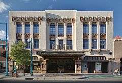
Some of the local museums, galleries, shops and other points of interest include the Albuquerque Biological Park, Albuquerque Museum, Museum of Natural History and Science, and Old Town Albuquerque. Albuquerque's live music/performance venues including; Isleta Amphitheater, Tingley Coliseum, Sunshine Theater and the KiMo Theater.
The local cuisine prominently features green chile, which is widely available in restaurants, including national fast-food chains. The restaurant scene of Albuquerque is quite prominent throughout the city, and local restaurants receive statewide attention, alongside several of them becoming chains throughout the state.
The Sandia Peak Tramway, located adjacent to Albuquerque, is the world's second-longest passenger aerial tramway. It also has the world's third-longest single span. It stretches from the Northeast edge of the city to the crestline of the Sandia Mountains. Elevation at the top of the tramway is roughly 10,300 ft (3,100 m). above sea level.
International Balloon Fiesta
The Albuquerque International Balloon Fiesta is an event that takes place at balloon fiesta park the first week of October. The Balloon Fiesta is one of Albuquerque's biggest attractions. Hundreds of hot air balloons are able to be seen everyday. In addition to balloons, there is live music, arts and crafts, and food.[51]
Architecture

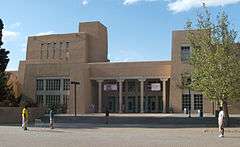
John Gaw Meem, credited with developing and popularizing the Pueblo Revival style, was based in Santa Fe but received an important Albuquerque commission in 1933 as the architect of the University of New Mexico. He retained this commission for the next quarter-century and developed the university's distinctive Southwest style.[16] :317 Meem also designed the Cathedral Church of St. John in 1950.[52]
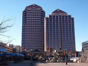
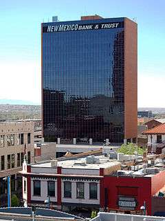
Albuquerque boasts a unique nighttime cityscape. Many building exteriors are illuminated in vibrant colors such as green and blue. The Wells Fargo Building is illuminated green. The DoubleTree Hotel and the Compass Bank building are illuminated blue. The rotunda of the county courthouse is illuminated yellow, while the tops of the Bank of Albuquerque and the Bank of the West are illuminated reddish-yellow. Due to the nature of the soil in the Rio Grande Valley, the skyline is lower than might be expected in a city of comparable size elsewhere.
Albuquerque has expanded greatly in area since the mid-1940s. During those years of expansion, the planning of the newer areas has considered that people drive rather than walk. The pre-1940s parts of Albuquerque are quite different in style and scale from the post 1940s areas. These older areas include the North Valley, the South Valley, various neighborhoods near downtown, and Corrales. The newer areas generally feature four to six lane roads in a 1 mile (1.61 km) grid. Each 1 square mile (2.59 km²) is divided into four 160-acre (0.65 km2) neighborhoods by smaller roads set 0.5 miles (0.8 km) between major roads. When driving along major roads in the newer sections of Albuquerque, one sees strip malls, signs, and cinderblock walls. The upside of this planning style is that neighborhoods are shielded from the worst of the noise and lights on the major roads. The downside is that it is virtually impossible to go anywhere from home without driving.
Tallest buildings
| Rank | Building | Height | Floors | Built | |
|---|---|---|---|---|---|
| 1 | Bank of Albuquerque Tower | 351 feet (107 m) | 22 | 1990 | |
| 2 | Hyatt Regency Albuquerque | 256 feet (78 m) | 21 | 1990 | |
| 3 | Compass Bank Tower | 240 feet (73 m) | 18 | 1966 | |
| 4 | Bank of the West Tower, West | 235 feet (72 m) | 15 | 1986 | |
| 5 | Bank of the West Tower, East | 213 feet (65 m) | 17 | 1963 | |
| 6 | Gold Building | 203 feet (62 m) | 14 | 1959 | |
| 7 | Dennis Chavez Federal Building | 197 feet (60 m) | 13 | 1965 | |
| 8 | PNM Resources Tower | 184 feet (56 m) | 12 | 1968 | |
| 9 | Simms Building | 180 feet (55 m) | 13 | 1954 | |
| 10 | Pete V. Domenici U.S. Courthouse | 176 feet (54 m) | 7 | 1997 |
Sports

The Albuquerque Isotopes are a minor league affiliate of the Colorado Rockies, having derived their name from The Simpsons March 2001 episode "Hungry, Hungry Homer", which involves the Springfield Isotopes baseball team considering relocating to Albuquerque.[53][54] Prior to 2002, the Albuquerque Dukes served as the city's minor league team, having played at the Albuquerque Sports Stadium. The stadium was torn down to make room for the current Isotopes Park.
In 2013 the United Soccer League announced the Albuquerque Sol soccer club will begin play in 2014.[55] Albuquerque is also home to Jackson–Winkeljohn gym, a mixed martial arts (MMA) gym. Several MMA world champions and fighters, including Holly Holm and Jon Jones, train in that facility.[56][57] Roller sports are finding a home in Albuquerque as they hosted USARS Championships in 2015,[58] and are home to Roller hockey,[59] and Roller Derby teams.[60]
| Team | Sport | League | Venue | capacity |
|---|---|---|---|---|
| Albuquerque Isotopes | Baseball | AAA PCL | Isotopes Park | 13,279 |
| Albuquerque Sol | Soccer | Premier Development League | Ben Rios Field | 1,500 |
| Duke City Gladiators | Indoor Football | Champions Indoor Football | Tingley Coliseum | 11,571 |
| New Mexico Lobos | NCAA Division I FBS Football | Mountain West Conference | University Stadium | 42,000 |
| New Mexico Lobos (men and women) | NCAA Division I Basketball | Mountain West Conference | The Pit | 15,411 |
| Albuquerque Roller Derby | Roller Derby | Wells Park Community Center |
Parks and recreation
- See also the External links section

The city was ranked No. 1 as the fittest city in the United States, according to a March 2007 issue of Men's Fitness magazine. The criteria used in the study included the availability of gyms and bike paths, commute times, and federal health statistics on obesity-related injuries and illnesses.
Albuquerque has a botanical and zoological complex called the Albuquerque Bio Park.
Government
| Albuquerque registered voters as of July, 2016[61] | |||||
|---|---|---|---|---|---|
| Party | Number of Voters | Percentage | |||
| Democratic | 127,662 | 42.02% | |||
| Republican | 100,404 | 33.05% | |||
| Unenrolled/Minor | 75,742 | 24.93% | |||

Albuquerque is a charter city.[62][63] City government is divided into an executive branch, headed by a Mayor[62]:V and a nine-member Council that holds the legislative authority.[62]:IV The form of city government is therefore mayor-council government. The mayor is Richard J. Berry, a former state legislator, who was elected in 2009.
The Mayor of Albuquerque holds a full-time paid elected position with a four-year term.[64] Albuquerque City Council members hold part-time paid positions and are elected from the nine districts for four-year terms, with four or five Councilors elected every two years.[65] Elections for Mayor and Councilor are nonpartisan.[62]:IV.4[63] Each December, a new Council President and Vice-President are chosen by members of the Council.[64] Each year, the Mayor submits a city budget proposal for the year to the Council by April 1, and the Council acts on the proposal within the next 60 days.[62]:VII
The Albuquerque City Council is the legislative authority of the city, and has the power to adopt all ordinances, resolutions, or other legislation.[65] The Council meets two times a month, with meetings held in the Vincent E. Griego Council Chambers in the basement level of Albuquerque/Bernalillo County Government Center.[66] Ordinances and resolutions passed by the Council are presented to the Mayor for his approval. If the Mayor vetoes an item, the Council can override the veto with a vote of two-thirds of the membership of the Council.[62]:XI.3
The judicial system in Albuquerque includes the Bernalillo County Metropolitan Court.
Police department
The Albuquerque Police Department (APD) is the police department with jurisdiction within the city limits, with anything outside of the city limits being considered the unincorporated area of Bernalillo County and policed by the Bernalillo County Sheriff's Department. It is the largest municipal police department in New Mexico, and in September 2008 the US Department of Justice recorded the APD as the 49th largest police department in the United States.[67]
In November 2012, the United States Department of Justice launched an investigation into APD's policies and practices to determine whether APD engages in a pattern or practice of use of excessive force in violation of the Fourth Amendment and the Violent Crime Control and Law Enforcement Act of 1994, 42 U.S.C. § 14141 ("Section 14141").[68] As part of its investigation, the Department of Justice consulted with police practices experts and conducted a comprehensive assessment of officers' use of force and APD policies and operations. The investigation included tours of APD facilities and Area Commands; interviews with Albuquerque officials, APD command staff, supervisors, and police officers; a review of numerous documents; and meetings with the Albuquerque Police Officers Association, residents, community groups, and other stakeholders.[69] When the Department of Justice concluded its investigation, it issued a scathing report that uncovered a "culture of acceptance of the use of excessive force" involving significant harm or injury by APD officers against people who posed no threat and which was not justified by the circumstances. The DOJ recommended a nearly complete overhaul of the department's use-of-force policies. Among several systematic problems at APD were an aggressive culture that undervalued civilian safety and discounted the importance of crisis intervention.[70]
Economy
| Largest employers in Albuquerque | |
|---|---|
| 1 | Kirtland Air Force Base |
| 2 | University of New Mexico |
| 3 | Sandia National Laboratories |
| 4 | Albuquerque Public Schools |
| 5 | Presbyterian Health Services |
| 6 | City of Albuquerque (Government) |
| 7 | Lovelace–Sandia Health System |
| 8 | Intel Corporation |
| 9 | State of New Mexico (Government) |
| 10 | Wal-Mart Stores, Inc. |
Albuquerque lies at the center of the New Mexico Technology Corridor, a concentration of high-tech private companies and government institutions along the Rio Grande. Larger institutions whose employees contribute to the population are numerous and include Sandia National Laboratories, Kirtland Air Force Base, and the attendant contracting companies which bring highly educated workers to a somewhat isolated region. Intel operates a large semiconductor factory or "fab" in suburban Rio Rancho, in neighboring Sandoval County, with its attendant large capital investment. Northrop Grumman is located along I-25 in northeast Albuquerque, and Tempur-Pedic is located on the West Mesa next to I-40.
The solar energy and architectural-design innovator Steve Baer located his company, Zomeworks, to the region in the late 1960s; and Los Alamos National Laboratory, Sandia, and Lawrence Livermore National Laboratory cooperate here in an enterprise that began with the Manhattan Project. In January 2007, Tempur-Pedic opened an 800,000-square-foot (74,000 m2) mattress factory in northwest Albuquerque. SCHOTT Solar, Inc., announced in January 2008 they will open a 200,000-square-foot (19,000 m2) facility manufacturing receivers for concentrated solar thermal power plants (CSP) and 64MW of photovoltaic (PV) modules. The facility closed in 2012.
Forbes magazine rated Albuquerque as the best city in America for business and careers in 2006[71] and as the 13th best (out of 200 metro areas) in 2008.[72] The city was rated seventh among America's Engineering Capitals in 2014 by Forbes magazine.[73] Albuquerque ranked among the Top 10 Best Cities to Live by U.S. News & World Report in 2009[74] and was recognized as the fourth best place to live for families by the TLC network.[75] It was ranked among the Top Best Cities for Jobs in 2007[76] and among the Top 50 Best Places to Live and Play by National Geographic Adventure magazine.[77]
Education
Albuquerque is home to the University of New Mexico, the largest public flagship university in the state. UNM includes a School of Medicine which was ranked in the top 50 primary care-oriented medical schools in the country.[78] The Central New Mexico Community College is a county-funded junior college serving new high school graduates and adults returning to school. (The school was formerly called the Albuquerque Technical Vocational Institute or TVI).
Albuquerque is also home to the following programs and non-profit schools of higher learning: Southwest University of Visual Arts, Southwestern Indian Polytechnic Institute, Trinity Southwest University, the University of St. Francis College of Nursing and Allied Health Department of Physician Assistant Studies, and the St. Norbert College Master of Theological Studies program.[79] The Ayurvedic Institute, one of the first Ayurveda colleges specializing in Ayurvedic medicine outside of India was established in the city in 1984. Other state and not-for-profit institutions of higher learning have moved some of their programs into Albuquerque. These include: New Mexico State University, Highlands University, Lewis University, Wayland Baptist University, and Webster University. Several for-profit technical schools including Pima Medical Institute, ITT Technical Institute, National American University, Grand Canyon University, the University of Phoenix and several barber/beauty colleges have established their presence in the area.
Albuquerque Public Schools (APS), one of the largest school districts in the nation, provides educational services to over 87,000 children across the city. Schools within APS include both public and charter entities. Numerous accredited private preparatory schools also serve Albuquerque students. These include various pre-high school religious (Christian, Jewish, Islamic) affiliates and Montessori schools, as well as Menaul School, Albuquerque Academy, St. Pius X High School, Sandia Preparatory School, the Bosque School, Evangel Christian Academy, Hope Christian School, Hope Connection School, Temple Baptist Academy, and Victory Christian. Accredited private schools serving students with special education needs in Albuquerque include: Desert Hills, Pathways Academy, and Presbyterian Ear Institute Oral School. The New Mexico School for the Deaf runs a preschool for children with hearing impairments in Albuquerque.
Infrastructure
Transportation
Main highways
Some of the main highways in the metro area include:
- Pan-American Freeway:[80]:248 More commonly known as Interstate 25 or "I-25", it is the main north–south highway on the city's eastern side of the Rio Grande. It is also the main north–south highway in the state (by connecting Albuquerque with Santa Fe and Las Cruces) and a plausible route of the eponymous Pan American Highway. Since Route 66 was decommissioned in the 1980s, the only remaining US highway in Albuquerque, unsigned US-85, shares its alignment with I-25. US-550 splits off to the northwest from I-25/US-85 in Bernalillo.
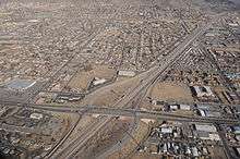 Aerial view of Interstate 40
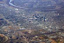
 - Coronado Freeway:[80]:248 More commonly known as Interstate 40 or "I-40", it is the city's main east–west traffic artery and an important transcontinental route. The freeway's name in the city is in reference to 16th century conquistador and explorer Francisco Vásquez de Coronado.
- Paseo del Norte: (aka; State Highway 423): This 6-lane highway is approximately five miles north of Interstate-40. It runs from Tramway Blvd (at the base of the Sandia Mountains) to Interstate 25, through Los Ranchos de Albuquerque, over the Rio Grande River to North Coors Boulevard. Paseo Del Norte then continues west through the Petroglyph National Monument until it reaches Atrisco Vista Blvd and the Double Eagle II Airport. (the extension of this highway through this National Park from Golf Course Rd., through to Unser Blvd., was finally approved and opened in 2007). (Note: Interstate-25 and Paseo del Norte intersection under construction beginning in 2013, completed 2014).
- Coors Boulevard: Coors is the main north-south artery to the west of the Rio Grande River in Albuquerque. There is one full interchange where it connects with Interstate 40. The rest of the route has stoplights, sidewalks and bike lanes. To the north of Interstate 40, part of the route is numbered as State Highway 448, while to the south, part of the route is numbered as State Highway 45.
- Central Avenue: Central is one of the historical routings of Route 66, it is no longer a main through highway, its usefulness having been supplanted by Interstate 40.[80]:248
- Alameda Boulevard: The main road to Rio Rancho, Alameda Blvd. stretches from Tramway Rd. to Coors. Blvd. Like Paseo del Norte, Alameda Blvd. is a freeway, that stretches from Corrales Rd. to Jefferson St.
- Tramway Boulevard: Serves as a bypass around the northeastern quadrant, the route is designated as NM-556. Tramway Boulevard starts at I-25 near Sandia Pueblo, and heads east as a two-lane road. It turns south near the base of the Sandia Peak Tramway and becomes a divided highway until its terminus near I-40 and Central Avenue by the western entrance to Tijeras Canyon.
The interchange between I-40 and I-25 is known as the "Big I".[80]:248 Originally built in 1966, it was rebuilt in 2002. The Big I is the only 5 level stack interchange in the state of New Mexico.
There are other major roads in Albuquerque too. These include San Mateo, Osuna, San Antonio, Academy, Carlisle, Lead, Coal, Rio Bravo, University, Lomas, Broadway/Edith, Montgomery/Montaño, Comanche, Rio Grande, Unser, 98th Street, Eubank, Juan Tabo, Louisiana, Wyoming, San Pedro, Gibson, Jefferson, Candelaria, and Menaul. The minor ones include Bridge, Corrales, Ellison/McMahon, Paradise Blvd, Golf Course Rd, Avenida Cesar Chavez, Isleta, Sunport, Dennis Chavez, Indian School, and Constitution.
Bridges
There are six road bridges that cross the Rio Grande and serve the municipality on at least one end if not both. The eastern approaches of the northernmost three all pass through adjacent unincorporated areas, the Village of Los Ranchos de Albuquerque, or the North Valley. In downstream order they are:
- Alameda Bridge
- Paseo del Norte Bridge
- Montaño Bridge
- I-40 Bridge
- Central at Old Town Bridge
- Barelas Bridge
Two more bridges serve urbanized areas contiguous to the city's perforated southern boundary.
- Rio Bravo Bridge (NM 500)
- I-25 Bridge (near Isleta Pueblo)
Rail
The state owns most of the city's rail infrastructure which is used by a commuter rail system, long distance passenger trains, and the freight trains of the BNSF Railway.
Freight service
BNSF Railway operates a small yard operation out of Abajo yard, located just south of the Cesar E. Chavez Ave. overpass and the New Mexico Rail Runner Express yards. Most freight traffic through the Central New Mexico region is processed via a much larger hub in nearby Belen, New Mexico.
Intercity rail
Amtrak's Southwest Chief, which travels between Chicago and Los Angeles, serves the Albuquerque area daily with one stop in each direction at the Alvarado Transportation Center in downtown.
Commuter rail
The New Mexico Rail Runner Express, a commuter rail line, began service between Sandoval County and Albuquerque in July 2006 using an existing BNSF right-of-way which was purchased by New Mexico in 2005. Service expanded to Valencia County in December 2006 and to Santa Fe on December 17, 2008. Rail Runner now connects Santa Fe, Sandoval, Bernalillo, and Valencia Counties with thirteen station stops, including three stops within Albuquerque.[81] The trains connect Albuquerque to downtown Santa Fe with eight roundtrips per weekday. The section of the line running south to Belen is served less frequently.[82]
Local mass transit
Albuquerque was one of two cities in New Mexico to have had electric street railways. Albuquerque's horse-drawn streetcar lines were electrified during the first few years of the 20th century. The Albuquerque Traction Company assumed operation of the system in 1905. The system grew to its maximum length of 6 miles (9.7 km) during the next ten years by connecting destinations such as Old Town to the west and the University of New Mexico to the east with the town's urban center near the former Atchison, Topeka & Santa Fe Railway depot. The Albuquerque Traction Company failed financially in 1915 and the vaguely named City Electric Company was formed. Despite traffic booms during the first world war, and unaided by lawsuits attempting to force the streetcar company to pay for paving, that system also failed later in 1927, leaving the streetcar's "motorettes" unemployed.[83]:177–181
Today, Alvarado Station provides convenient access to other parts of the city via the city bus system, ABQ RIDE. ABQ RIDE operates a variety of bus routes, including the Rapid Ride express bus service.
In 2006 the City of Albuquerque under the mayorship of Martin Chavez had planned and attempted to "fast track" the development of a "Modern Streetcar" project. Funding for the US$270 million system was not resolved as many citizens vocally opposed the project. The city and its transit department maintain a policy commitment to the streetcar project.[84] The project would run mostly in the southeast quadrant on Central Avenue and Yale Boulevard.
As of 2011, the city is working on a study to develop a bus rapid transit system through the Central Ave. corridor. This corridor carried 44% of all bus riders in the ABQ Ride system, making it a natural starting point for enhanced service.[85]
Bicycle transit
Albuquerque has a well-developed bicycle network.[86] In and around the city there are trails, bike routes, and paths that provide the residents and visitors with alternatives to motorized travel. In 2009, the city was reviewed as having a major up and coming bike scene in North America.[87] The same year, the City of Albuquerque opened its first Bicycle Boulevard on Silver Avenue.[88] There are plans for more investment in bikes and bike transit by the city, including bicycle lending programs, in the coming years.[89]
Walkability
A 2011 study by Walk Score ranked Albuquerque below average at 28th most walkable of the fifty largest U.S. cities.[90]
Airports
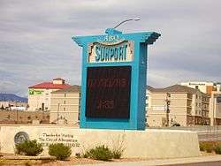
Albuquerque is served by two airports, the larger of which is Albuquerque International Sunport. It is located 3 miles (5 km) southeast of the central business district of Albuquerque. The Albuquerque International Sunport served 5,888,811 passengers in 2009.[91] Double Eagle II Airport is the other airport. It is primarily used as an air ambulance, corporate flight, military flight, training flight, charter flight, and private flight facility.[92]
Utilities
Energy
PNM Resources, New Mexico's largest electricity provider, is based in Albuquerque. They serve about 487,000 electricity customers statewide. New Mexico Gas Company provides natural gas services to more than 500,000 customers in the state, including the Albuquerque metro area.
Sanitation
The Albuquerque Bernalillo County Water Utility Authority is responsible for the delivery of drinking water and the treatment of wastewater.
South Side Water Reclamation Plant.
Healthcare
Albuquerque is the medical hub of New Mexico, hosting numerous state-of-the-art medical centers. Some of the city's top hospitals include the VA Medical Center, Presbyterian Hospital, Heart Hospital of New Mexico, and Lovelace Women's Hospital. The University of New Mexico Hospital is the primary teaching hospital for the state's only medical school and provides the state's only residency training programs, children's hospital, burn center and level I pediatric and adult trauma centers. The University of New Mexico Hospital is also the home of a certified advanced primary stroke center as well as the largest collection of adult and pediatric specialty and subspecialty programs in the state.
Media
The city is served by one major newspaper, the Albuquerque Journal, and several smaller daily and weekly papers, including the alternative Weekly Alibi. Albuquerque is also home to numerous radio and television stations that serve the metropolitan and outlying rural areas.
Pop culture
In film
Many Bugs Bunny cartoon shorts feature Bugs traveling around the world by burrowing underground; he gets lost quite often while traveling and remarks, while consulting a map, "Should have made a left toin at Albukoykee". (Bugs first uses that line in 1945's Herr Meets Hare.)[93]
Some parts of the 1999 movie Pirates of the Silicon Valley were shot in Albuquerque.
Albuquerque has been featured in Hollywood movies such as Little Miss Sunshine (2006), Sunshine Cleaning (2008), and Brothers (2009).
In 2013, Albuquerque was listed on MovieMaker magazine's annual list of Top 10 Cities to be a Movie Maker.[94]
All three of Disney's High School Musical movies are set in Albuquerque, at the fictional Albuquerque East High School (Wildcats) whose athletic (and academic) rivals are the fictional Albuquerque West High School (Knights). While the trilogy took place in Albuquerque, filming took place in Salt Lake City.
Marvel Studios' film The Avengers (2012) was mostly (>75%) filmed at the Albuquerque Studios.[95]
A Million Ways to Die in the West (2014), directed by Seth MacFarlane, was filmed in various areas in and around Albuquerque.
The 2013 film Force of Execution starring Steven Seagal is set and filmed in Albuquerque.
In music
Musicians who have lived in Albuquerque include Jim Morrison, Glen Campbell, Bo Diddley, Demi Lovato, Eric McFadden, Rahim Al-Haj, and Bernadette Seacrest.
Music groups based in Albuquerque include A Hawk and A Hacksaw, Beirut, The Eyeliners, Hazeldine, Leiahdorus, Scared of Chaka, and The Shins.
The song "Albuquerque" by Weird Al Yankovic tells the story of a man moving to the city, and his absurd misadventures while living there.
Neil Young's song "Albuquerque" can be found on the album Tonight's the Night.
"Point Me in the Direction of Albuquerque" is a song on The Partridge Family Album.
In television
Albuquerque is the setting for the television shows In Plain Sight and Breaking Bad, with the latter significantly boosting tourism in the area.[96][97][98][99][100]
The 2015 TV series Better Call Saul, a Breaking Bad spin-off, also takes place and is shot in Albuquerque.[101]
Ethel Mertz (played by Vivian Vance), from the 1950s sitcom I Love Lucy, often refers to Albuquerque as her hometown.
Episode 15 of Season 12 of The Simpsons features Albuquerque as an antagonistic faction, planning to buy the Springfield Isotopes baseball team.
Notable people
Sister cities

Albuquerque has ten sister cities, as designated by Sister Cities International:
|
See also
Notes
References
- ↑ Albuquerque Municipal Elections Retrieved July 26, 2012
- 1 2 3 "Annual Estimates of the Resident Population: April 1, 2010 to July 1, 2014". U.S. Census Bureau. Archived from the original on April 17, 2016. Retrieved July 19, 2015.
- ↑ State & County QuickFacts. Census.gov
- ↑ "ABQ Trolley Co. – BURQUEÑOS". Abqtrolley.com. March 20, 2009. Retrieved February 18, 2012.
- ↑ "Find a County". National Association of Counties. Archived from the original on May 31, 2011. Retrieved June 7, 2011.
- ↑ "Metropolitan and Micropolitan – Data – People and Households – U.S. Census Bureau". Census.gov. Retrieved March 29, 2014.
- ↑ "Odd names abound in this state". Reading Eagle. Jan 1, 1970. p. 2. Retrieved 31 October 2015.
- ↑ "Albuquerque". Online Etymology Dictionary.
- ↑ James J. Parsons. The Cork Oak Forests and the Evolution of the Cork Industry in Southern Spain and Portugal. 1962. Clark University
- ↑ Brochure "Alburquerque: Villa Medieval" Excmo. Ayuntamiento de Alburquerque and Banco Bilbao Vizcaya. 2006
- ↑ Eddie Pells, If in Doubt, You Can Just Call It Albuquirky, Los Angeles Times, May 21, 1995.
- ↑ L. B. Mitchell. The Meaning of the Name Albuquerque. Western Folklore, Vol. 8, No. 3 (Jul. 1949), pp. 255–256
- ↑ "About - Albuquerque Historical Society". Albuquerque Historical Society. Retrieved 2016-01-04.
- ↑ "History". Nmallstar.com. Retrieved February 18, 2012.
- ↑ New Mexico Department of Cultural Affairs, Historic Preservation Division. "San Felipe de Neri Church Historical Marker".
- 1 2 Simmons, Marc (1982). Albuquerque. Albuquerque: University of New Mexico Press. ISBN 0-8263-0627-6.
- ↑ "Home". congregationalbert.org.
- ↑ Les Christie, CNNMoney.com staff writer (June 28, 2007). "The fastest growing U.S. cities — June 28, 2007". CNN. Retrieved May 9, 2009.
- 1 2 3 4 "Race and Hispanic Origin for Selected Cities and Other Places: Earliest Census to 1990". U.S. Census Bureau. Retrieved April 23, 2012.
- ↑ Siermers, Erick (September 17, 2007). "Managing Albuquerque's growth". Archived from the original on February 22, 2010. Retrieved September 17, 2007.
- ↑ "Planned Growth Strategy". Cabq.gov. March 19, 2007. Archived from the original on May 17, 2008. Retrieved July 2, 2010.
- ↑ "Petroglyph National Monument". Nps.gov. June 10, 2010. Archived from the original on August 28, 2010. Retrieved July 2, 2010.
- ↑ Metcalf, Richard. "ABQ third-best metro for making money owning rental housing." Albuquerque Journal. October 7, 2013.
- ↑ "Geographic Identifiers: 2010 Demographic Profile Data (G001): Albuquerque city, New Mexico". U.S. Census Bureau, American Factfinder. Retrieved January 27, 2014.
- 1 2 Laura Calabrese. "Vegetation & The Environment in NM". University of New Mexico. Retrieved July 24, 2012.
- 1 2 Stephen Ausherman (2012). 60 Hikes Within 60 Miles: Albuquerque: Including Santa Fe, Mount Taylor, and San Lorenzo Canyon (2nd ed.). Menasha Ridge Press. p. 288. ISBN 9780897326001.
- ↑ "Albuquerque Basin". The New Mexico Bureau of Geology & Mineral Resources. Retrieved September 28, 2012.
- 1 2 Robert Julyan, The Place Names of New Mexico (revised edition), UNM Press, 1998.
- 1 2 "WMO Climate Normals for ALBUQUERQUE/INT'L ARPT NM 1961–1990". National Oceanic and Atmospheric Administration. Retrieved 2014-03-11.
- ↑ "NCDC: U.S. Climate Normals" (PDF). Retrieved October 31, 2010.
- ↑ http://planthardiness.ars.usda.gov/PHZMWeb/Images/300dpi/NM.jpg
- ↑ "Preliminary total snowfall reports across central and northern New Mexico from the December 28–30 winter storm". National Weather Service Albuquerque, NM. December 31, 2006. Retrieved August 5, 2009.
- ↑ "NowData – NOAA Online Weather Data". National Oceanic and Atmospheric Administration. Retrieved February 16, 2013.
- ↑ "Station Name: NM ALBUQUERQUE INTL AP". National Oceanic and Atmospheric Administration. Retrieved 2014-03-21.
- ↑ "Station Name: NM ALBUQUERQUE VALLEY". National Oceanic and Atmospheric Administration. Retrieved 2014-04-22.
- ↑ "Station Name: NM ALBUQUERQUE FOOTHILLS". National Oceanic and Atmospheric Administration. Retrieved 2014-04-22.
- ↑ Your Drinking Water http://www.abcwua.org/Your_Drinking_Water.aspx Accessed August 1, 2013 Albuquerque Bernalillo Water Authority
- ↑ Odenwald, Arlene Cinelli (April 1993). "Protecting the aquifer: Albuquerque reacting". New Mexico Business Journal. 17 (4): 38–39. ISSN 0164-6796. Retrieved December 23, 2008.
- 1 2 "Albuquerque Bernalillo County Water Utility Authority: Water Resource Management Strategy" (PDF). Albuquerque Bernalillo County Water Utility Authority. January 10, 2007. Archived (PDF) from the original on October 29, 2008. Retrieved October 18, 2008.
- ↑ The project's page at the United States Bureau of Reclamation's website
- ↑ "The Albuquerque Bernalillo County Water Utility Authority". Abcwua.org. December 7, 2008. Retrieved July 2, 2010.
- ↑ "Adopted Santolina Level A Master Plan-Bernalillo County, New Mexico". bernco.gov.
- ↑ "Annual Estimates of the Resident Population for Incorporated Places: April 1, 2010 to July 1, 2015". Retrieved July 2, 2016.
- ↑ "Census of Population and Housing". Census.gov. Archived from the original on May 11, 2015. Retrieved June 4, 2015.
- ↑ "Albuquerque (city), New Mexico". State & County QuickFacts. U.S. Census Bureau.
- ↑ "American FactFinder". United States Census Bureau. Archived from the original on September 11, 2013. Retrieved January 31, 2008.
- ↑ "Albuquerque (city), New Mexico". State & County QuickFacts. U.S. Census Bureau. Retrieved April 23, 2012.
- 1 2 "American FactFinder". Factfinder2.census.gov. October 5, 2010. Retrieved February 18, 2012.
- ↑ Roberts, Susan A.; Roberts, Calvin A. (1998). A History of New Mexico. Albuquerque, NM: University of New Mexico Press. p. 387. ISBN 0-8263-1792-8.
- ↑ "New Mexico Arts and Crafts Fair". Nmartsandcraftsfair.org. New Mexico Arts and Crafts Fair. 2014. Retrieved January 29, 2014.
- ↑ http://www.balloonfiesta.com/guest-guide
- ↑ "History of the Diocese". Diocese of the Rio Grande. Retrieved January 3, 2014.
- ↑ "Doh! Go Isotopes!". Seattle Post-Intelligencer. Hearst Corporation. May 13, 2003. p. C8.
- ↑ Latta, Dennis (September 5, 2002). "Team President Throws Isotopes Name Into Play". Albuquerque Journal. Albuquerque Publishing Company. p. A1.
- ↑ "Albuquerque Sol FC Joins PDL (press release)". USLSoccer.com. December 5, 2013. Archived from the original on July 9, 2014. Retrieved July 30, 2014.
- ↑ Raimondi, Marc (June 6, 2014). "UFC's first Albuquerque show is a long time coming for Jackson's MMA". Fox Sports. Archived from the original on December 18, 2014. Retrieved December 18, 2014.
- ↑ Wright, Rick (August 3, 2014). "Duke City a dominant force in MMA". Albuquerque Journal. Archived from the original on December 18, 2014. Retrieved December 18, 2014.
- ↑ Star, Kevin Abourezk | Lincoln Journal. "Roller skating champions to return to Lincoln in 2016 : Lincoln, NE Journal Star". Retrieved 2015-09-29.
- ↑ "Club Hockey (Aztecs)". Archived from the original on September 30, 2015. Retrieved 2015-09-29.
- ↑ Dewing, Sonja. "Hell on Skates: Roller derby enters the new millennium". Retrieved 2015-09-29.
- ↑ Albuquerque Registered Voter Enrollment: 2016
- 1 2 3 4 5 6 "Charter of the City of Albuquerque". American Legal Publishing Corporation. Retrieved December 10, 2009.
this link should work after going to http://www.amlegal.com/ home page
- 1 2 "Charter of the City of Albuquerque [PDF]" (PDF). City of Albuquerque. Retrieved December 10, 2009.
- 1 2 "Council — Frequently Asked Questions (FAQ) – City of Albuquerque". City of Albuquerque. Archived from the original on January 31, 2009. Retrieved December 26, 2008.
- 1 2 "Albuquerque City Council". City of Albuquerque. Archived from the original on December 18, 2008. Retrieved December 26, 2008.
- ↑ "City Council Meetings Schedule". City of Albuquerque. Archived from the original on January 31, 2009. Retrieved December 26, 2008.
- ↑ United States Department of Justice (2008). "Census of State and Local Law Enforcement Agencies" (PDF). Retrieved March 31, 2014.
- ↑ "United States V. City Of Albuquerque" (PDF). U.S. Department Of Justice. U.S. Department Of Justice. Retrieved 4 May 2015.
- ↑ "United States V. City Of Albuquerque" (PDF). U.S. Department Of Justice. U.S. Department Of Justice. Retrieved 4 May 2015.
- ↑ Mike Gallagher, "Scathing Report on APD Use of Force," Albuquerque Journal, April 11, 2014. Page A1.
- ↑ "Best Places For Business And Careers 2006". Forbes. January 1, 2006. Retrieved January 20, 2009.
- ↑ "Best Places For Business And Careers". Forbes. March 19, 2008. Archived from the original on January 22, 2009. Retrieved December 23, 2008.
- ↑ "America's Engineering Capitals".
- ↑ "Best Places to Live 2009".
- ↑ "Top 10 Cities for Families". 2011.
- ↑ "Top 10 Cities For Jobs 2007".
- ↑ "Best Places to Live + Play: Cities". 2007.
- ↑ "America's Best Graduate Schools 2008". Archived from the original on December 14, 2007. Retrieved January 19, 2008.
- ↑ Ebert, Howard. "SNC Master of Theological Studies". 2012. St. Norbert College. Retrieved August 11, 2013.
- 1 2 3 4 Bryan, Howard (1989). Albuquerque Remembered. Albuquerque: University of New Mexico Press. ISBN 0-8263-3782-1. OCLC 62109913. Retrieved August 5, 2009.
- ↑ "New Mexico Rail Runner Express: Stations listed North to South". New Mexico Rail Runner. Retrieved August 2, 2009.
- ↑ "New Mexico Rail Runner Express Monday–Friday Schedule" (PDF). New Mexico Rail Runner Express. December 2, 2008. Archived from the original (PDF) on January 14, 2009. Retrieved December 23, 2008.
- ↑ Myrick, David F (1970). New Mexico's Railroads --- An Historical Survey. Golden, Colorado: Colorado Railroad Museum. Library of Congress Catalog Card No. 70-116915.
- ↑ Gisick, Michael (December 4, 2006). "Council: Streetcar project rushed". Albuquerque Tribune. Archived from the original on October 4, 2010. Retrieved April 26, 2009.
- ↑ "Planning for the Future: Bus Rapid Transit (BRT) Service on Central Avenue". CABQ.gov. Retrieved October 5, 2011.
- ↑ "Biking in Albuquerque". City of Albuquerque.
- ↑ Eric Smillie (April 27, 2009). "Sorry, Portland". Archived from the original on June 26, 2009. Retrieved August 5, 2009.
- ↑ Jeremy Jojola; Joshua Panas (January 14, 2009). "Bike Boulevard to run through ABQ". KOB New Mexico. Retrieved August 5, 2009.
- ↑ "Albuquerque To Launch Bike-Sharing Program". abqjournal.com.
- ↑ "2011 City and Neighborhood Rankings". Walk Score. 2011. Retrieved August 28, 2011.
- ↑ "Sunport Facts & Figures". City of Albuquerque. Archived from the original on February 13, 2009. Retrieved February 12, 2009.
- ↑ "Double Eagle II Airport". City of Albuquerque. Archived from the original on February 3, 2009. Retrieved February 12, 2009.
- ↑ "Herr Meets Hare". BCDB. January 10, 2013.
- ↑ "Top 10 Cities to Be a Moviemaker". March 5, 2013.
- ↑ "Behind the Scenes: "The Avengers" in Albuquerque, NM". May 14, 2012.
- ↑ Janela, Mike. "Breaking Bad Cooks Up Record-Breaking Formula for Guinness World Records 2014 Edition". Guinness World Records 2014. Guinness World Records. Retrieved October 19, 2013.
- ↑ Faust, Chris Gray (August 11, 2013). "'Breaking Bad' has been very good for Albuquerque". U.S.A. Today. Gannett Company, Inc. Retrieved October 19, 2013.
- ↑ Verrier, Richard. "'Breaking Bad' Tourism Boost Will Last Long After Series Leaves Albuquerque". Los Angeles Times. MCT Information Services. Retrieved October 19, 2013.
- ↑ The Associated Press. "'Breaking Bad' brings tourists to Albuquerque for 'meth' treats like blue rock candy, bath salts". New York Daily News. New York Daily News. Retrieved October 19, 2013.
- ↑ Thoren, Laura. "Buzz surrounds 'burial' for Walter White 'Breaking Bad' character to have services in ABQ cemetery". KOAT-TV 7 News report. Hearst. Retrieved October 20, 2013.
- ↑ "Better Call Saul in Albuquerque". visitalbuquerque.org.
- ↑ "Sister Cities, Public Relations". Guadalajara municipal government. Archived from the original on March 2, 2012. Retrieved March 12, 2013.
Further reading
- Ciotola, Nicholas P. "Italian immigrants in Albuquerque, 1880 to 1930: A study in Western distinctiveness." Journal of the West 43.4 (2004): 41-48.
- Luckingham, Bradford. The urban southwest: a profile history of Albuquerque, El Paso, Phoenix, Tucson (Texas Western Press, 1982)
- Simmons, Marc. Albuquerque: a narrative history (University of New Mexico Press, 1982)
External links
- Official government website
- 1905 Magazine Article with historical photos
- Albuquerque, New Mexico at DMOZ
- Articles relating to Albuquerque, New Mexico
 Municipalities and communities of Bernalillo County, New Mexico, United States
Cities 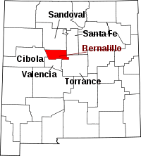
Town Villages CDPs Other
unincorporated
communitiesIndian reservations Footnotes ‡This populated place also has portions in an adjacent county or countiesSanta Fe (capital)Topics - Index
- Delegations
- Geography
- Government
- History
- Landmarks
- Military
- Nuevomexicanos
- New Mexicans
- Paleontology
- Municipalities
- Census-designated places
- Symbols
- Transportation
- Tribes
- Visitor attractions
- New Mexican cuisine
Society Regions Cities Counties