Albershausen
| Albershausen | ||
|---|---|---|
| ||
 Albershausen | ||
Location of Albershausen within Göppingen district 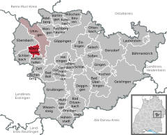
 | ||
| Coordinates: 48°41′29″N 9°33′54″E / 48.69139°N 9.56500°ECoordinates: 48°41′29″N 9°33′54″E / 48.69139°N 9.56500°E | ||
| Country | Germany | |
| State | Baden-Württemberg | |
| Admin. region | Stuttgart | |
| District | Göppingen | |
| Government | ||
| • Mayor | Jochen Bidlingmaier | |
| Area | ||
| • Total | 6.50 km2 (2.51 sq mi) | |
| Population (2015-12-31)[1] | ||
| • Total | 4,196 | |
| • Density | 650/km2 (1,700/sq mi) | |
| Time zone | CET/CEST (UTC+1/+2) | |
| Postal codes | 73095 | |
| Dialling codes | 07161 | |
| Vehicle registration | GP | |
| Website | www.albershausen.de | |

Albershausen is a municipality in the district of Göppingen in Baden-Württemberg in southern Germany.
Location
Albershausen is located between the lower Filstal and the Swabian Jura at the Butzbach, a small left tributary of the Fils. The village stretches along the national road B 297 between Uhingen and Kirchheim unter Teck.
Municipality arrangement
Albershausen includes the village Albershausen, the Weiler Schafhof and the homestead Öschlenshof and the risen in Albershausen or dialed villages Schlichingen, Büheln, Haßlach, Negelli, Bettenweiler and Schenkenmühle.[2]

Mayor
The mayor is elected for a term of eight years. Since 21 April 2010, Jochen Bidlingmaier is the mayor of Albershausen. He received when choosing 7 February 2010 83.3% of the vote.
Crest
The blazon of the municipal coat of arms of Albershausen is: In silver the green capital letter A, including a linkshin lying green tulip. The arms of Albershausen is the only letter of Arms in the district of Göppingen. On 3 February 1959, the Ministry of Internal Affairs of the municipality gave the flag colors green and white.[3]
Teams
A total of around 20 clubs in Albershausen are active. The TSGV Albershausen 1896 eV (gymnastics, sports and singing club). It is the biggest club with 16 departments and offers from american football to table tennis a wide range of sports.[4]
Literature
- Municipality Albershausen: 700 Jahre Albershausen 1275-1975, Albershausen 1975
- Haas, Erwin: Albershausen im Wandel der Zeit, Albershausen 1989
- Haas, Erwin: Geschichten aus Albershausen, Albershausen 1989
| Wikimedia Commons has media related to Albershausen. |
References
- ↑ "Gemeinden in Deutschland nach Fläche, Bevölkerung und Postleitzahl am 30.09.2016". Statistisches Bundesamt (in German). 2016.
- ↑ Das Land Baden-Württemberg. Amtliche Beschreibung nach Kreisen und Gemeinden. Band III: Regierungsbezirk Stuttgart, Regionalverband Mittlerer Neckar. Kohlhammer, Stuttgart 1978, ISBN 3-17-004758-2. S. 344–345
- ↑ Eberhard Gönner und Heinz Baruda: Wappenbuch des Landkreises Göppingen, Herausgegeben vom Landkreis Göppingen und der Archivdirektion Stuttgart, Verlag W. Kohlhammer, Stuttgart 1966
- ↑ Internetauftritt des TSGV Albershausen, abgerufen am 1. Juni 2011