South Bruce Peninsula
- South Bruce Peninsula is not to be confused with the Municipality of South Bruce, Ontario
| South Bruce Peninsula | |
|---|---|
| Town (lower-tier) | |
| Town of South Bruce Peninsula | |
|
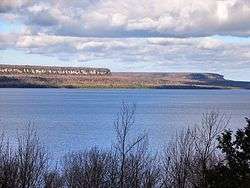
The Malcolm Bluff near Purple Valley, as seen across Colpoy's Bay | |
 South Bruce Peninsula Location in southern Ontario | |
| Coordinates: 44°44′N 81°12′W / 44.733°N 81.200°WCoordinates: 44°44′N 81°12′W / 44.733°N 81.200°W | |
| Country |
|
| Province |
|
| County | Bruce |
| Formed | January 1, 1999 |
| Government | |
| • Mayor | Janice Jackson |
| • Federal riding | Bruce—Grey—Owen Sound |
| • Prov. riding | Bruce—Grey—Owen Sound |
| Area[1] | |
| • Land | 538.32 km2 (207.85 sq mi) |
| Population (2011)[1] | |
| • Total | 8,413 |
| • Density | 15.6/km2 (40/sq mi) |
| Time zone | EST (UTC-5) |
| • Summer (DST) | EDT (UTC-4) |
| Postal Code | N0H |
| Area code(s) | 519 and 226 |
| Website |
www.southbrucepeninsula .com |

.jpg)
South Bruce Peninsula is a town at the base of the Bruce Peninsula of Ontario, Canada, in Bruce County between Lake Huron and Georgian Bay. It was formed on January 1, 1999, when the Town of Wiarton, the Village of Hepworth, and the townships of Albemarle and Amabel were amalgamated.
Recently the cottage industry has become the major industry in the area. Many cottages are found along Sauble Beach (North and South).
Communities
The town comprises the communities of Adamsville, Colpoy's Bay, Hepworth, Hope Bay, Howdenvale, Mar, McIvor, Oliphant, Park Head, Purple Valley, Red Bay, Sauble Beach, Sauble Beach North, Sauble Beach South, Sauble Falls, Skipness, Tolmie and Wiarton. The administrative centre of the region is found in Wiarton.
Demographics
| Canada census – South Bruce Peninsula community profile | |||
|---|---|---|---|
| 2011 | 2006 | 2001 | |
| Population: | 8413 (0.0% from 2006) | 8415 (4.0% from 2001) | 8090 (1.1% from 1996) |
| Land area: | 538.32 km2 (207.85 sq mi) | 531.90 km2 (205.37 sq mi) | 531.92 km2 (205.38 sq mi) |
| Population density: | 15.6/km2 (40/sq mi) | 15.8/km2 (41/sq mi) | 15.2/km2 (39/sq mi) |
| Median age: | 49.9 (M: 48.7, F: 50.9) | 47.3 (M: 46.5, F: 47.9) | |
| Total private dwellings: | 6959 | 6759 | 6741 |
| Median household income: | $45,577 | $41,334 | |
| References: 2011[1] 2006[2] 2001[3] | |||
Mother tongue:[2]
- English as first language: 94.9%
- French as first language: 0.4%
- English and French as first language: 0%
- Other as first language: 4.8%
Population trend:[4]
- Population in 2011: 8413
- Population in 2006: 8415
- Population in 2001: 8090
- Population total in 1996: 8004
- Albemarle (township): 1217
- Amabel (township): 3917
- Hepworth (village): 470
- Wiarton (town): 2400
- Population in 1991:
- Albemarle (township): 1140
- Amabel (township): 3815
- Hepworth (village): 453
- Wiarton (town): 2326
Attractions
The main tourist attractions for the area are Sauble Beach, Wiarton Willie (Groundhog Day), and fishing locations such as Pike Bay.
The region has many annual festivals such as Sandfest held in the location Sauble Beach as well as the Oliphant regetta.
See also
References
- 1 2 3 "South Bruce Peninsula census profile". 2011 Census of Population. Statistics Canada. Retrieved 2012-03-16.
- 1 2 "2006 Community Profiles". Canada 2006 Census. Statistics Canada. March 30, 2011. Retrieved 2012-03-16.
- ↑ "2001 Community Profiles". Canada 2001 Census. Statistics Canada. February 17, 2012. Retrieved 2012-03-16.
- ↑ Statistics Canada: 1996, 2001, 2006 census
External links
| Wikimedia Commons has media related to South Bruce Peninsula. |
 |
Northern Bruce Peninsula | Neyaashiinigmiing 27 | | |
| Saugeen and Cape Croker Fishing Islands 1 / Lake Huron / Chief's Point 28 | |
Georgian Bay Georgian Bluffs | ||
| ||||
| | ||||
| Saugeen 29 | Arran–Elderslie |