Alamein railway line
| Alamein | |||
|---|---|---|---|
| Overview | |||
| Type | Melbourne suburban service | ||
| System | Metro Trains Melbourne | ||
| Connecting lines | Belgrave and Lilydale lines | ||
| Former connections | Outer Circle | ||
| Stations | 6 | ||
| Services | Shuttle to/from Camberwell station at most times | ||
| Operation | |||
| Commenced | 1890 | ||
| Completed | 1948 | ||
| Rolling stock | Comeng, X'Trapolis | ||
| Number of tracks | Double track to outside Ashburton, single track beyond | ||
| |||
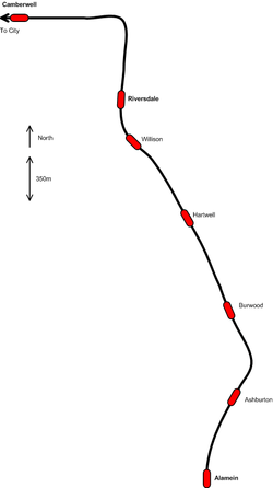
The Alamein railway line is a suburban electric railway in Melbourne, Australia. It serves part of the City of Boroondara, to the east of the Melbourne central business district. It has six stations and branches from the Belgrave and Lilydale lines at Camberwell station. It is entirely within PTV ticketing Zone 1.
Description
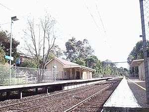
The Alamein line heads south from Camberwell across gentle hills, with some moderately heavy earthworks. The line crosses under or over several roads by means of bridges, and only has two level crossings, one of which carries tram tracks, one of three such tram/train crossings in Melbourne. The area served by the line is fully built up and a mostly residential area.
The line is operated as a shuttle service between Camberwell and Alamein stations during off-peak periods, while trains run the whole distance to Flinders Street Station during peak hours.
Infrastructure
The line is double track from the junction at Camberwell station to just north of Ashburton station; changing to a single track for the rest of the distance, a short enough section that it is not a serious bottleneck. The maximum permissible train speed limits range from 65 km/h (40 mph) on most of the double track sections, to 40 km/h (25 mph) on the single track, and 30 km/h (19 mph) over the tram/train level crossing on the line.
There is a crossover point at Riversdale station, which allows trains to turn back when they cannot proceed. There are no stabling facilities on the line, although there is a single, rarely used siding at Ashburton station. The city-bound track between Camberwell and Riversdale stations is signalled for two-way running. This is used by shuttle services when running at frequencies greater than 15 minutes.
History
What is now known as the Alamein line was opened as the Outer Circle Railway between 1890 and 1891. The segment still in use today was opened on 24 March 1890.[1] By the 1900s, only the Deepdene to Ashburton section of the original line was operational. Electrification of the Melbourne network also commenced at this time, with the Victorian Railways Commissioners deciding to include the Camberwell to Ashburton section of the Outer Circle in the project, the last steam train running on 29 October 1924 and electric trains commencing 3 days later.[2]
The line from Camberwell to the terminus was single line with no crossing places provided, as single train running a shuttle along the line from Camberwell. Staff and Ticket safeworking was used, except between Camberwell and Riversdale when Lever Locking & Track Control was provided on 2 November 1924. Patronage and revenue on the line doubled after electrification, and on 12 October 1925 a 30 to 45 minute connecting service was provided to Ashburton.[1]
From 26 November 1928 two trains were provided at peak hours, with Hartwell opened as a crossing station eight days before to permit this.[1] A signal frame was provided on 8 December 1938 due to increased traffic.[3] Through trains to the city at peak hour were provided from 17 May 1934, though some through trains from the Kew line were deleted to provide train paths to the city. From 3 October 1938 the daytime off peak frequency was improved to 15 minutes.[4] On 28 June 1948 the line extension to the new Housing Commission of Victoria estate of Alamein was opened, with most trains extended to the new terminus, except for a minority that turned back at Ashburton.[4] After World War II, as part of Operation Phoenix, plans were drawn up to duplicate the line and provide a flying junction connection at Camberwell. It was authorised in 1951, but was delayed due to funding issues and other competing projects.[5] Earthworks were not completed until December 1958, with the extra platforms at Willison, Burwood and Riversdale also under way, track work being complete by October 1954.[5] The first 2.2-kilometre (1.4 mi) long stage opened on 7 November 1954, from Hartwell to Ashburton stations, followed by the duplication and automatic signalling of the 1.6 km (1 mi) Riversdale to Hartwell section on 31 July 1955. From 15 July 1955, Ashburton station ceased to be a regular terminus.[4]
However reduced loan funds for railway construction during 1955 and 1956 delayed the rest of the works,[5] with the overpass and new line at Camberwell finally commissioned on 29 November 1959. The last stage of the works had to wait until 8 November 1962 when automatic signalling was introduced between Hartwell and Ashburton, and the signal bay at Hartwell closed.[3]
On 30 November 1959, off-peak services on the line were cut to 20 minutes during the day and about 35 minutes at night, and on 23 October 1961, the Saturday frequency was cut to every 40 minutes.[3] From 26 February 1968 Alamein trains ran at 23 minute frequencies during working hours, otherwise every 46 minutes. A one car Tait train took over the service on Sundays, the train guard selling tickets as station staff were withdrawn from every station except Ashburton, which remained open for safeworking reasons.[3] From 9 July 1972, the service was cut to every hour on Sundays, and from 10 December 1973 it was changed to 20 minutes during the day and every 40 minutes at night and on Saturday afternoons. Through trains to Flinders Street off-peak were provided from 20 January 1975 at a frequency of every 15 minutes Monday to Friday, with Box Hill trains running express from Camberwell.[3]
The train staff and ticket system between Ashburton and Alamein was abolished in August 1977. Control of this section of line was transferred to Ashburton.[6]
The Comeng trains were introduced to the Melbourne railway system in 1981. Initially, along with the Alamein line, they were only allowed to operate on the Belgrave, Dandenong, Glen Waverley and Lilydale lines, due to the width of the trains (10 feet).[7]
Although moves were made to close the line or convert it to light rail in the 1980s, the Alamein line has remained open.
The line was also the first in the city to receive new Metlink-branded signage, including the new, blue colour code for the train network, and signs directing passengers to connecting tram and bus services. These signs have since been replaced with PTV branded signage.
Services
Most Alamein line services (including all weekend services) operates as a shuttle from Camberwell, extending to Flinders Street during weekday peak periods. During the morning peak, citybound services stops all stations to Flinders Street except East Richmond, running anticlockwise through the City Loop. During the same period, most outbound services stops all stations to Alamein, one service skips East Richmond, one service terminates at Riversdale, one service runs express from Richmond to Camberwell, and one service operates the same express except also stopping at Glenferrie. During the early afternoon peak and late evening peak, outbound and citybound services run clockwise through the City Loop, stopping all stations, while during the main evening peak, outbound services run direct from Flinders Street, also stopping all stations, and citybound services either stop at all stations, skip East Richmond, or operate express from Camberwell to Richmond, stopping at Glenferrie. At all other times, services operate as a shuttle to and from Camberwell, connecting with Belgrave and Lilydale line trains.
Line guide

Bold stations are termini, where some train services terminate; italic stations are staffed.
Branches from the Belgrave and Lilydale lines at Camberwell.
Alamein railway line | |||||||||||||||||||||||||||||||||||||||||||||||||||||||||||||||||||||||||||||||||||||||||||||||||||||||||||||||||||||
|---|---|---|---|---|---|---|---|---|---|---|---|---|---|---|---|---|---|---|---|---|---|---|---|---|---|---|---|---|---|---|---|---|---|---|---|---|---|---|---|---|---|---|---|---|---|---|---|---|---|---|---|---|---|---|---|---|---|---|---|---|---|---|---|---|---|---|---|---|---|---|---|---|---|---|---|---|---|---|---|---|---|---|---|---|---|---|---|---|---|---|---|---|---|---|---|---|---|---|---|---|---|---|---|---|---|---|---|---|---|---|---|---|---|---|---|---|---|
Legend | |||||||||||||||||||||||||||||||||||||||||||||||||||||||||||||||||||||||||||||||||||||||||||||||||||||||||||||||||||||
| |||||||||||||||||||||||||||||||||||||||||||||||||||||||||||||||||||||||||||||||||||||||||||||||||||||||||||||||||||||
References
- 1 2 3 S.E. Dornan and R.G. Henderson (1979). Electric Railways of Victoria. Australian Electric Traction Society. p. 84. ISBN 0-909459-06-1.
- ↑ David Beardsell and Bruce Herbert (1979). The Outer Circle: A history of the Oakleigh to Fairfield Park Railway. Australian Railway Historical Society (Victorian Division). p. 63. ISBN 0-85849-024-2.
- 1 2 3 4 5 S.E. Dornan and R.G. Henderson (1979). Electric Railways of Victoria. Australian Electric Traction Society. p. 86. ISBN 0-909459-06-1.
- 1 2 3 S.E. Dornan and R.G. Henderson (1979). Electric Railways of Victoria. Australian Electric Traction Society. p. 85. ISBN 0-909459-06-1.
- 1 2 3 David Beardsell and Bruce Herbert (1979). The Outer Circle: A history of the Oakleigh to Fairfield Park Railway. Australian Railway Historical Society (Victorian Division). p. 67. ISBN 0-85849-024-2.
- ↑ "Works". Newsrail. Australian Railway Historical Society. October 1977. p. 228.
- ↑ "Traffic". Newsrail. Australian Railway Historical Society. August 1981. p. 185.
External links
| Wikimedia Commons has media related to Alamein railway line. |
- Timetables
- Official line map
- Metropolitan train network map
- Statistics and detailed schematic map at the VicSig enthusiast website