Al-Malikiyah District
| al-Malikiyah District منطقة المالكية | |
|---|---|
| District | |
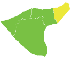 Location of al-Malikiyah District within al-Hasakah Governorate | |
| Coordinates (al-Malikiyah): 37°10′N 42°08′E / 37.17°N 42.13°ECoordinates: 37°10′N 42°08′E / 37.17°N 42.13°E | |
| Country |
|
| Governorate | al-Hasakah |
| Seat | al-Malikiyah |
| Subdistricts | 3 nawāḥī |
| Area | |
| • Total | 2,652.74 km2 (1,024.23 sq mi) |
| Population (2004)[1] | 191,994 |
| Geocode | SY0803 |
al-Malikiyah District (Arabic: منطقة المالكية, translit. manṭiqat al-Mālikiyah; Kurdish: Devera Dêrika Hemko) is a district of al-Hasakah Governorate in northeastern Syria. Administrative centre is the city of al-Malikiyah.
al-Malikiyah is both the northernmost and easternmost district in Syria. At the 2004 census, it had a population of 191,994.[1]
Subdistricts
The district of al-Malikiyah is divided into three subdistricts or nawāḥī (population as of 2004[1]):
| PCode | Name | Area | Population | Villages | Seat |
|---|---|---|---|---|---|
| SY080300 | Nahiya al-Malikiyah | 1,264.22 km² | 112,000 | 108 | al-Malikiyah |
| SY080301 | Nahiya al-Jawadiyah | 383.44 km² | 40,535 | 50 | al-Jawadiyah |
| SY080302 | Nahiya al-Yaarubiyah | 1,005.08 km² | 39,459 | 62 | al-Yaarubiyah |
References
- 1 2 3 "General Census of Population and Housing 2004" (PDF) (in Arabic). Syrian Central Bureau of Statistics. Retrieved 15 October 2015. Also available in English: "2004 Census Data". UN OCHA. Retrieved 15 October 2015.
This article is issued from Wikipedia - version of the 6/6/2016. The text is available under the Creative Commons Attribution/Share Alike but additional terms may apply for the media files.