Al-Ghizlaniyah
| Al-Ghizlaniyah الغزلانية | |
|---|---|
| Town | |
 Al-Ghizlaniyah | |
| Coordinates: 33°23′55″N 36°27′11″E / 33.39861°N 36.45306°E | |
| Country |
|
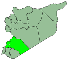
| Governorate | Rif Dimashq |
| District | Douma |
| Subdistrict | Al-Ghizlaniyah |
| Population (2004)[1] | |
| • Total | 10,473 |
| Time zone | EET (UTC+3) |
| • Summer (DST) | EEST (UTC+2) |
Al-Ghizlaniyah (Arabic: الغزلانية) is a village in southern Syria, administratively part of the Douma District of the Rif Dimashq Governorate, located east of Damascus. Nearby localities include Khirbet al-Ward to the west, al-Adiliyah to the southwest, Burraq to the south, al-Hayjanah to the southeast, Judaydat al-Khas to the east, Ghasulah and Harran al-Awamid, Sakka to the north, Deir al-Asafir and Shabaa to the northwest. According to the Syria Central Bureau of Statistics (CBS), al-Ghizlaniyah had a population of 10,473 in the 2004 census. It is the administrative center of the al-Ghizlaniyah nahiyah ("subdistrict") which consisted of 13 localities with a collective population of 36,715 in 2004.[1]
References
- 1 2 General Census of Population and Housing 2004. Syria Central Bureau of Statistics (CBS). Rif Dimashq Governorate. (Arabic)
This article is issued from Wikipedia - version of the 12/20/2014. The text is available under the Creative Commons Attribution/Share Alike but additional terms may apply for the media files.