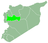
Al-Bayda, Hama Governorate
| Al-Bayda البيضا | |
|---|---|
| Village | |
 Al-Bayda Location in Syria | |
| Coordinates: 35°02′17″N 36°20′14″E / 35.03806°N 36.33722°ECoordinates: 35°02′17″N 36°20′14″E / 35.03806°N 36.33722°E | |
| Country |
|
| Governorate | Hama |
| District | Masyaf |
| Subdistrict | Masyaf |
| Elevation | 510 m (1,670 ft) |
| Population (2004)[1] | |
| • Total | 1,173 |
Al-Bayda (Arabic: البيضا) is a village in northwestern Syria located west of Hama, 95 km (59 mi) southeast of the port city of Latakia, and 210 km (130 mi) north of Damascus. It is administratively part of the Hama Governorate. Nearby localities include Masyaf 2 kilometers to the north, al-Suwaydah to the southeast, Ayn Halaqim to the south, and Wadi al-Oyun to the southwest. According to the Syria Central Bureau of Statistics (CBS), al-Bayda had a population of 1,173 in the 2004 census.[1]
History
Al-Bayda was founded by Ibrahim Bolous Ghanemeh in about 1730. The town is home to the San Gawargeos church, which was built in 1814.
Demographics
Al-Bayda's inhabitants are almost exclusively Greek Orthodox under the patriarchate of Antioch.
Economy
Most of Al-Bayda's residents work in agriculture, tourism, or for the government.
See also
References
- 1 2 General Census of Population and Housing 2004. Syria Central Bureau of Statistics (CBS). Hama Governorate. (Arabic)
External links
| Wikimedia Commons has media related to Al-Bayda, Hama Governorate. |

