Aksaray
| Aksaray | |
|---|---|
| Municipality | |
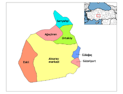 Location of Aksaray within Turkey. | |
 Aksaray Location of Aksaray within Turkey. | |
| Coordinates: 38°22′N 34°02′E / 38.367°N 34.033°E | |
| Country |
|
| Region | Central Anatolia |
| Province | Aksaray |
| Government | |
| • Governor | Şeref Ataklı |
| • Mayor | Haluk Sahin YAZGI (AKP) |
| Area[1] | |
| • District | 4,588.87 km2 (1,771.77 sq mi) |
| Elevation | 980 m (3,220 ft) |
| Population (2012)[2] | |
| • Urban | 186,599 |
| • District | 270,528 |
| • District density | 59/km2 (150/sq mi) |
| Time zone | EET (UTC+2) |
| • Summer (DST) | EEST (UTC+3) |
| Postal code | 68xxx |
| Area code(s) | 0382 |
| Licence plate | 68 |
| Website | www.aksaray.gov.tr |
Aksaray (pronounced [ˈaksaɾaj]) is a city in the Central Anatolia region of Turkey and the capital district of Aksaray Province. According to 2009 census figures, the population of the province is 376 907 of which 171,423 live in the city of Aksaray.[3][4] The district covers an area of 4,589 km2 (1,772 sq mi),[5] and the average elevation is 980 m (3,215 ft), with the highest point being Mt. Hasan at 3,253 m (10,673 ft).
History
Aksaray region was an important stopover along the Silk Road that crossed through Anatolia for centuries and the city of Aksaray has a long history.
The town of Garsaura was named Archelaïs (Greek: Ἀρχελαΐς) by Archelaus of Cappadocia, the last Cappadocian king. In Roman times, the town was known as Colonia (Κολώνεια) and was a bishopric and an important military centre, holding an imperial aplekton. Of its bishops, Euphrasius was at the First Council of Nicaea in 325, Bosporus (who is mentioned in correspondence of Basil the Great and Gregory of Nazianzus) at the First Council of Constantinople in 381, Daniel at the Council of Ephesus in 431, Aristomachus (who was also a signatory of the letter of the bishops of the Roman province of Cappadocia Tertia, to which Colonia belonged, to Byzantine Emperor Leo I the Thracian about the killing of Proterius of Alexandria in 458) at the Council of Chalcedon in 451, Alexander at a council called by Patriarch Menas of Constantinople in 536, and Conon at the Trullan Council of 692.[6][7][8] No longer a residential bishopric, Colonia in Cappadocia is today listed by the Catholic Church as a titular see.[9] Colonia is also a titular metropolis in Turkey of the Ecumenical Patriarchate of Constantinople.
The town was also prosperous during Ottoman times due to its proximity to Tuz Gölü (Lake Tuz), which was a primary source of salt for Anatolia.[10]
The region came under the control of the Seljuk Turks after the Battle of Manzikert in 1071. The Anatolian Seljuk Sultanate they founded left important landmarks in and around Aksaray. The Moroccan traveller Ibn Battuta who was in the region in the 14th century was impressed by the class of Muslim traders that had emerged in Aksaray and noted the urban centre as "a beautiful city, surrounded by waterways and gardens, with a water supply coming right to the houses of the city."
Aksaray was incorporated into the Ottoman Empire in 1470 by the İshak Pasha, and many inhabitants of the city were relocated to Constantinople, recently captured by the Ottomans, where they were settled in a quarter of the city that came to be named Aksaray.
Aksaray today
Today Aksaray is a quiet mid-size city. In recent past, many inhabitants migrated to Britain, Germany and other European countries for job opportunities.
Ihlara Valley and the other tourist attractions of Cappadocia are close, but as yet, Aksaray has not been very successful in attracting visitors to the city itself. A new attraction in Aksaray city is Hünkarland, a large theme park with artificial waterfalls and which has immediately become a popular venue for Aksaray wedding parties.
Cuisine
This is a rich agricultural region producing grains, meat and dairy and many kinds of fruit and vegetables. Therefore, the cuisine of the town is of high standard. Well-known dishes include many pastries and other kinds of wheat-based dishes such as:
- yufka a thick filo-pastry, eaten like bread or filled with cheese (or meats and other fillings) and toasted on a hot griddle (sıkma, katmer or sac böreği depending on the filling)
- many kinds of local pasta or cous-cous including one stuffed with meat and steamed like ravioli, (called mantı)
- tarhana a soup made from a dried mixture of wheat-flour, spices and yoghurt
- pelte and sweet of flour, syrup and butter
- höşmerim, kaygana and many other rich sweets, mostly involving butter and flour
Other dishes include soups made with okra or yoghurt and a thick floury chicken stew called Arabaşı.
Climate
Aksaray has a cold semi-arid climate (BSk) under the Köppen and either a hot summer continental climate (Dca) or hot summer oceanic (Doa) under the Trewartha classification.
| Climate data for Aksaray (1950 - 2014) | |||||||||||||
|---|---|---|---|---|---|---|---|---|---|---|---|---|---|
| Month | Jan | Feb | Mar | Apr | May | Jun | Jul | Aug | Sep | Oct | Nov | Dec | Year |
| Record high °C (°F) | 19.4 (66.9) |
21.6 (70.9) |
29.0 (84.2) |
31.8 (89.2) |
33.8 (92.8) |
36.9 (98.4) |
40.0 (104) |
38.8 (101.8) |
36.5 (97.7) |
32.8 (91) |
26.2 (79.2) |
22.0 (71.6) |
40 (104) |
| Average high °C (°F) | 5.4 (41.7) |
7.2 (45) |
12.4 (54.3) |
17.9 (64.2) |
22.8 (73) |
27.0 (80.6) |
30.5 (86.9) |
30.4 (86.7) |
26.4 (79.5) |
20.6 (69.1) |
13.5 (56.3) |
7.6 (45.7) |
18.47 (65.25) |
| Daily mean °C (°F) | 0.5 (32.9) |
2.0 (35.6) |
6.5 (43.7) |
11.6 (52.9) |
16.2 (61.2) |
20.4 (68.7) |
23.7 (74.7) |
23.1 (73.6) |
18.5 (65.3) |
12.9 (55.2) |
6.9 (44.4) |
2.5 (36.5) |
12.07 (53.72) |
| Average low °C (°F) | −3.7 (25.3) |
−2.5 (27.5) |
1.1 (34) |
5.5 (41.9) |
9.4 (48.9) |
12.9 (55.2) |
16.0 (60.8) |
15.6 (60.1) |
11.0 (51.8) |
6.5 (43.7) |
1.7 (35.1) |
−1.5 (29.3) |
6 (42.8) |
| Record low °C (°F) | −26.4 (−15.5) |
−29.0 (−20.2) |
−19.0 (−2.2) |
−7.5 (18.5) |
−0.2 (31.6) |
2.9 (37.2) |
6.8 (44.2) |
5.9 (42.6) |
1.0 (33.8) |
−6.0 (21.2) |
−14.0 (6.8) |
−21.9 (−7.4) |
−29 (−20.2) |
| Average precipitation mm (inches) | 38.7 (1.524) |
33.5 (1.319) |
38.6 (1.52) |
46.3 (1.823) |
39.6 (1.559) |
23.7 (0.933) |
5.7 (0.224) |
3.5 (0.138) |
8.4 (0.331) |
24.8 (0.976) |
32.0 (1.26) |
44.2 (1.74) |
339 (13.347) |
| Average precipitation days | 10.1 | 10.2 | 10.4 | 11.0 | 10.2 | 5.9 | 1.6 | 1.3 | 2.7 | 6.1 | 7.5 | 10.7 | 87.7 |
| Mean daily sunshine hours | 3.2 | 4.3 | 5.5 | 7.0 | 9.1 | 11.2 | 12.1 | 11.4 | 10.0 | 7.1 | 5.0 | 3.1 | 7.42 |
| Source: Turkish State Meteorological Service[11] | |||||||||||||
Places of interest
- Hasan Dağı – a 3,000m volcano between Aksaray and Niğde, visible from the city.
- Aşıklı Höyük – a burial mound 25 km (16 mi) east of the city of Aksaray.
- Acemhöyük – an early Bronze Age settlement, 18 km (11 mi) north-west of the city of Aksaray.
- The ancient Roman and Byzantine city of Nora, in the village of Helvadere near the city of Aksaray.
- Ihlara – a canyon, 40 km (25 mi) from the city of Aksaray, contains ancient churches, (9th century and earlier) carved into the valley walls and decorated with frescoes.
- Ervah cemetery in the city contains the tombs of 14th century Islamic leader Somuncu Baba and the scholar Cemaleddin'i Aksaray.
- Zincirye Medresi, a Koranic school with a typical Seljuk portal, built by the bey of Karaman in 1345
Sports
The Runfire Cappadocia Ultramarathon, a multiday track running ultramarathon of desert concept, is held since 2012 annually in July. The race tours 244 km (152 mi) in six days through several places across Cappadocia reaching out to Lake Tuz.[12]
Mosques
- Karamanoğlu Camii – a large mosque in the city centre.
- Eğri Minare (Oblique Minaret) – a Seljuk Turkish minaret 1221–1236, built under the rule of Aläettin Keykubat I
- The high church – on a steep rock 3 km (2 mi) from the city.
Caravanserais
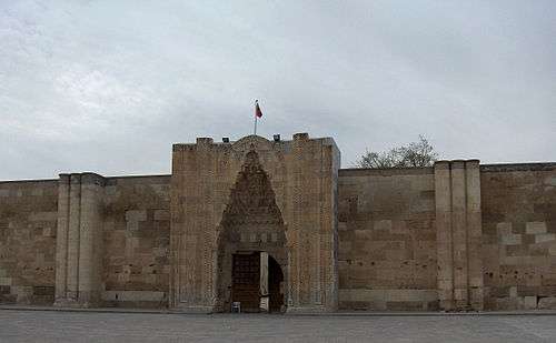
There are three monumental caravanserais in the neighbourhood of Aksaray. The best known is Sultan Han, located in the village Sultanhan about 40 km (25 mi) west of Aksaray. This fortified structure was built in 1229 (dated by inscription), during the reign of the Seljuk sultan Kayqubad I, by the Syrian architect Mohammed Bin Havlan El Dimaski (the work Dimasci indicating Damascus) along the trade route from Konya to Aksaray, leading to Persia (the Uzun Yolu). After it was partially destroyed by a fire, it was restored and extended in 1278 by the governor Seraceddin Ahmed Kerimeddin bin El Hasan during the reign of the sultan Kaykhusraw III. This monumental caravanserai then became the largest in Turkey. It is one of the best examples of Anatolian Seljuk architecture.
One enters the Sultanhanı in the east through a monumental 13 m high marble gate (pishtaq) projecting from the fifty-meters wide front wall. The gate is enclosed by a pointed arch decorated with muqarnas corbels and a plaiting with elegant geometric patterns. The open courtyard (44 x 58 m) was used in the summer, while the covered ones (iwans) on both side were used during the winter. In the middle of the open courtyard stands a square stoned kiosk-mosque (kösk mesçidi), the oldest example in Turkey. The mosque on the second floor sits on a construction of four carved barrel-vaulted arches. The arcades on both sides of the inner courtyard served as stables and has accommodations above.
At the other side of the courtyard is another arched entrance. It is equally decorated with a muqarnas niche, joggled voussoirs and interlocking geometric designs. The central aisle of the covered hall is covered with a barrel vault with transverse ribs. A short tower, capped by a dome, stands over the centre of the vault. This dome has an oculus, providing light and air to the hall.
Notable residents
- Piri Mehmed Pasha Ottoman Grand Vizier 1518–1523
International relations
Twin towns — sister cities
Aksaray is twinned with:
-
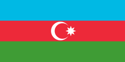 Ganja, Azerbaijan
 -
 Venice, Italy
 -
 Graz, Austria
 - Sankt Pölten, Austria
-
 Prades, France
 - Lons-le-Saunier, France
- Ajaccio, France
-
 Hódmezővásárhely, Hungary
 -
 Osaka, Japan
 -
 Banska Bystrica, Slovakia
 - Kosice, Slovakia
-
 Slovenska Bistrica, Slovenia
 -
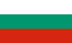 Burgas, Bulgaria
 -
 Petropavlovsk-Kamchatsky, Russian Federation
 -
 Dekemhare, Eritrea
Possible sister cities
Proposed sister cities
Notes
- ↑ "Area of regions (including lakes), km²". Regional Statistics Database. Turkish Statistical Institute. 2002. Retrieved 2013-03-05.
- ↑ "Population of province/district centers and towns/villages by districts - 2012". Address Based Population Registration System (ABPRS) Database. Turkish Statistical Institute. Retrieved 2013-02-27.
- ↑ Şehir, belde ve köy nüfusları – 2009 Archived October 4, 2011, at the Wayback Machine., Turkish Institute of Statistics
- ↑ GeoHive. "Statistical information on Turkey's administrative units". Retrieved 2008-04-02.
- ↑ Statoids. "Statistical information on districts of Turkey". Retrieved 2008-04-12.
- ↑ Michel Lequien, Oriens christianus in quatuor Patriarchatus digestus, Paris 1740, Vol. I, coll. 413-416
- ↑ Raymond Janin, v. 2. Colonia, in Dictionnaire d'Histoire et de Géographie ecclésiastiques, vol. XIII, Paris 1956, col. 326
- ↑ Pius Bonifacius Gams, Series episcoporum Ecclesiae Catholicae, Leipzig 1931, p. 440
- ↑ Annuario Pontificio 2013 (Libreria Editrice Vaticana 2013 ISBN 978-88-209-9070-1), p. 873
- ↑ Swan, Suzanne (2012) [1st pub. 2003], Eyewitness Travel Turkey, London, UK: Dorling Kindersley Ltd., ISBN 978-1-40536-888-9
- ↑ "Meteoroloji" (in Turkish). Retrieved 8 January 2016.
- ↑ "Elite Athletes to run at The Runfire Cappadocia". Istanbul Convention & Visitors Bureau. July 2013. Retrieved 2013-11-28.
References
- Stierlin, Henry. 1998. Turkey: From the Selçuks to the Ottomans. New York: Taschen, 240.
- Sultan Han Aksaray
- Yavuz, Aysil Tükel. 1997. The Concepts that Shape Anatolian Seljuq Caravanserais. In Muqarnas XIV: An Annual on the Visual Culture of the Islamic World. Gülru Necipoglu (ed). Leiden: E.J. Brill, 80–95 (download)
- Falling Rain Genomics, Inc. "Geographical information on Aksaray, Turkey". Retrieved 2008-04-02.
- Turkish Ministry of Culture and Tourism. "General information on Aksaray, Turkey" (in Turkish). Retrieved 2008-04-02.
- District governor's official website (Turkish) / (English) / (French)
External links
| Wikivoyage has a travel guide for Aksaray. |
| Wikimedia Commons has media related to Aksaray. |
- District governor's official website (Turkish) / (English) / (French)
- District municipality's official website (Turkish)
- Aksaray Historical Place Photos
- Aksaray Weather Forecast Information
- Maps of Aksaray
| Province: | ||
|---|---|---|
| District: |
| |
| Towns: | ||
| Villages: |
| |
Coordinates: 38°22′27″N 34°01′44″E / 38.37417°N 34.02889°E