Akraberg
 Akraberg Lighthouse | |
 Akraberg Lighthouse Faroe Islands | |
| Location |
Suðuroy, Faroe Islands Denmark |
|---|---|
| Coordinates | 61°23′40″N 6°40′45″W / 61.394428°N 6.679112°W |
| Year first constructed | 1909 |
| Foundation | concrete basement |
| Construction | cast iron |
| Tower shape | cylindrical tower with balcony and lantern |
| Markings / pattern | white tower and lantern, red lantern roof |
| Height | 14 metres (46 ft) |
| Focal height | 94 metres (308 ft) |
| Characteristic | two long (2 s) flashes every 20 s, white, red or green depending on direction |
| Fog signal | one blast every 60s. |
| Admiralty number | L4342 |
| NGA number | 17852 |
| ARLHS number | FAR-001 |
| Denmark number | DFL-6500[1] |
Akraberg is the southern tip of Suðuroy, 5 km south from the village Sumba, Faroe Islands. The name Akraberg derives from akur (cereal field). Five kilometres south of Akraberg is the southernmost point of The Faroe Islands, a rock called Munkurin (The Monk), also called Sumbiarsteinur, which is one of a group of six rocks. This group of rocks are called Flesjarnar. The sound between Suðuroy and Munkurin is notorious for its strong current, it is called Røstin, the poet Poul F. Joensen (born 1898, died 1970) mentioned it in one of his poems "...Røstin rísin rann...".
The waters south of Sumba are notorious for their unpredictability. Here lies a series of rocky skerries below and above sea level, and the meeting of currents, together with wind and weather, create dangerous conditions for boats and ships. The situation became more hazardous in 1884 when the high cliff "Munkurin" on the southernmost rock, Sumbiarsteinur, crashed into the sea and the seafarers lost the fixed landmark of the rocks.
The lighthouse
In 1909, a lighthouse and some family houses were built in Akraberg. The lighthouse itself is 14m tall, it consists of a white cylindrical tower with red landtern roof. It was fitted with guy wires to withstand the wind drag on this southern headland. The focal plane is located at 94 m above sea level, a flash signal is given every 20 seconds with red, green and white sectors. If needed, a fog horn may be sounded every 60 seconds.[2] Today, there are only two houses and a lighthouse, but there are no inhabitants. The last family who lived there was the lighthouse keeper Hans Petur Kjærbo and his family. They lived there during a terrible hurricane in December 1988, which later has been called The Christmas Hurricane. Luckily the house was very strong built and didn't get blasted away by the strong wind. But much damage had been done on their car, the soil and parts of the house; a window was blown out. Much damage happened in the Faroe Islands that night, many houses were blasted away by the hurricane. After that the lighthouse keeper and his family moved away from Akraberg, and nobody has lived there since then, except for tourists who rent one of the two houses there. The lighthouse is now automatic, but it needs attention regularly. Hans Petur Kjærbo is still a lighthouse keeper, but now he workes not only in Akraberg but also attends most of the other lighthouses in the Faroe Islands.
Medium wave station
Near Akraberg stands the medium wave station of Kringvarp Føroya, the Faroese broadcasting network. This transmits on 531 kHz. The antenna consists of a 141 metres tall guyed mast and can be received also in parts of Northern and Western Europe.
A peatland landscape
The peatland landscape above the headland of Akraberg at the southern tip of Suðuroy features relict peat cuttings of various age – from the 1950s and perhaps centuries before – as well as mounds of peat. The removal of dried peat from the torvløð and the continued use of the platforms led to a gradual increase in torvlað height. General comparisons are made with peat mounds from the British Isles. These features are of unknown antiquity, but they have been associated with the possible pre-Viking presence of Irish monks or priests (papar).[3]
History

The Frisian people
According to Faroese legends and folk songs a Frisian colony was in Akraberg from the year 1040 until The Black Death killed most of them around 1350. A few of them, a man called Bóndin í Akrabergi (The Farmer of Akraberg) was said to have survived the Black Death and after that he and his house hold moved to Sumba.[4] The Frisians remained heathen a long time after the rest of the Faroe Islands were Christianized. It is said that they partly lived by piracy and they are mentioned in several Faeroese legends.[5]
World War II in Akraberg
During World War II, Akraberg lighthouse and radio were serviced by technical Royal Air Force soldiers, working on one of the first radar stations, which scanned the water and air south of the Faroe Islands.[6] There are still some buildings in Akraberg from the World War II period, which were built by the British soldiers using armed concrete.
Climate
| Climate data for Akraberg, Suðuroy, 101 m.a.s.l. | |||||||||||||
|---|---|---|---|---|---|---|---|---|---|---|---|---|---|
| Month | Jan | Feb | Mar | Apr | May | Jun | Jul | Aug | Sep | Oct | Nov | Dec | Year |
| Record high °C (°F) | 9.6 (49.3) |
8.8 (47.8) |
9.2 (48.6) |
13.0 (55.4) |
15.2 (59.4) |
17.2 (63) |
17.6 (63.7) |
18.4 (65.1) |
17.2 (63) |
11.8 (53.2) |
10.8 (51.4) |
9.8 (49.6) |
18.4 (65.1) |
| Average high °C (°F) | 5.4 (41.7) |
5.4 (41.7) |
5.5 (41.9) |
6.5 (43.7) |
8.1 (46.6) |
9.9 (49.8) |
11.1 (52) |
11.4 (52.5) |
10.2 (50.4) |
8.8 (47.8) |
6.6 (43.9) |
5.8 (42.4) |
7.9 (46.2) |
| Daily mean °C (°F) | 3.8 (38.8) |
3.9 (39) |
4.0 (39.2) |
4.8 (40.6) |
6.6 (43.9) |
8.4 (47.1) |
9.6 (49.3) |
10.0 (50) |
8.9 (48) |
7.5 (45.5) |
5.1 (41.2) |
4.2 (39.6) |
6.4 (43.5) |
| Average low °C (°F) | 1.9 (35.4) |
2.0 (35.6) |
2.0 (35.6) |
2.9 (37.2) |
5.0 (41) |
6.9 (44.4) |
8.1 (46.6) |
8.5 (47.3) |
7.2 (45) |
5.8 (42.4) |
3.2 (37.8) |
2.2 (36) |
4.6 (40.3) |
| Record low °C (°F) | −7.2 (19) |
−10.6 (12.9) |
−7.0 (19.4) |
−9.3 (15.3) |
−4.0 (24.8) |
0.0 (32) |
2.0 (35.6) |
3.0 (37.4) |
0.0 (32) |
−2.6 (27.3) |
−5.6 (21.9) |
−8.4 (16.9) |
−10.6 (12.9) |
| Average precipitation mm (inches) | 90 (3.54) |
60 (2.36) |
77 (3.03) |
48 (1.89) |
43 (1.69) |
51 (2.01) |
65 (2.56) |
65 (2.56) |
94 (3.7) |
108 (4.25) |
90 (3.54) |
95 (3.74) |
884 (34.8) |
| Average precipitation days (≥ 1.0 mm) | 18 | 13 | 17 | 12 | 10 | 11 | 12 | 12 | 16 | 18 | 17 | 19 | 173 |
| Average relative humidity (%) | 85 | 85 | 85 | 85 | 88 | 89 | 91 | 91 | 89 | 87 | 84 | 84 | 87 |
| Source: Danish Meteorological Institute[7] | |||||||||||||
See also
Gallery
-
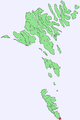
Location of Akraberg
-
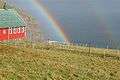
Akraberg – Double Rainbow
-
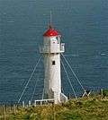
Akraberg Lighthouse
-

The Lighthouse in Akraberg.
-
The Foghorn in Akraberg, Faroe Islands.
-
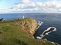
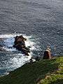
Akraberg Headland, the Lighthouse and one of the two houses.
-
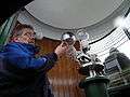
Hans Petur Kjærbo, the lighthouse keeper, is changing the bulbs in the lighthouse in Akraberg.
-

Fresnel Lens and Bulbs in the Lighthouse in Akraberg, Suduroy, Faroe Islands.
-

View from the lighthouse in Akraberg.
-

Faroese stamp, 2013, with Erik Christensens photo
References
- ↑ Rowlett, Russ. "Lighthouses of the Faroes". The Lighthouse Directory. University of North Carolina at Chapel Hill. Retrieved January 15, 2016.
- ↑ Rowlett, Russ. "Lighthouses of the Faroes". The Lighthouse Directory. University of North Carolina at Chapel Hill. Retrieved 16 March 2009.
- ↑ A peatland landscape at Akraberg, Suðuroy, Faroe Islands: Peat mounds and a cautionary lesson. Danish Journal of Geography, 2008, by: Kevin J. Edwards, Rolf Guttesen & Petur J. Sigvardsen
- ↑ "Um Frísar, Føroyingar og Frísalandsfólkini" (in Faroese and Danish). Retrieved 15 September 2016.
- ↑ [Suðuroyarsagnir by Dr. Jacobsen et.al.]
- ↑ BBC
- ↑ "The Climate of The Faroe Islands - with Climatological Standard Normals, 1961-1990 Greenland" (PDF). Danish Meteorological Institute. Retrieved August 19, 2015.
External links
| Wikimedia Commons has media related to Akraberg. |
- Flickr photo set of Akraberg
- Visitsuduroy.fo
- Amateur Radio Lighthouse Society
- SkyscraperPage Forum
- BBC – WW2 people's War. Akraberg and the lighthouse are mentioned in the article.
- Kringvarp Føroya (Faroes Broadcasting)
Coordinates: 61°23′36″N 6°40′43″W / 61.3932°N 6.67864°W