Akhaura Upazila
| Akhaura আখাউড়া | |
|---|---|
| Upazila | |
|
Akhaura Railway Station | |
 Akhaura Location in Bangladesh | |
| Coordinates: 23°52′05″N 91°12′30″E / 23.86806°N 91.20833°ECoordinates: 23°52′05″N 91°12′30″E / 23.86806°N 91.20833°E | |
| Country |
|
| Division | Chittagong Division |
| District | Brahmanbaria District |
| Government | |
| • Municipal Mayor | Takjil Khalifa Kajal |
| • Upazila Chairman | Muslem Uddin |
| Area | |
| • Total | 99.28 km2 (38.33 sq mi) |
| Population (1991) | |
| • Total | 112,982 |
| • Density | 1,100/km2 (2,900/sq mi) |
| Time zone | BST (UTC+6) |
| Postal Code | 3450 |

Akhaura (Bengali: আখাউড়া ) is an Upazila of Brahmanbaria District, a district of Chittagong, Bangladesh. Akhaura Upazila, with an area of 99.28 km2. The main river in the surrounding area is the Titas River. It played an important historical role during both World War II and Liberation War of Bangladesh.
The administration of Akhaura thana, now an upazila, was established in 1976. The upazila includes one municipality, five union parishads, 107 mouzas and 113 villages.[1]
Demographics
According to the 2011 District Statistics Report for Brahmanbaria, Akhaura has a population of 145,215. Males constitute approximately 70,000 of the population, and females 75,000. The majority of the population (95.2%) are Muslim with a minority (5.8%) following Hinduism. This upazila has a literacy rate of 52.7%. [2]
Points of interest
- Kharampur Mazar Sharif, the mausoleum of Hazrat Syed Ahmad Gechhudaraj (R), is a pilgrimage site for devotees.[1]
Transport
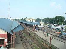
Plans are underway to have Akhaura will be connected to Agartala, India via railway by 2017.[3][4]
In year 2013-14, Bangladesh exported TK 2.26 billion through the Akhaura Land Port to India.[5]
Education
According to Banglapedia, Bangladesh Railway Government High School, founded in 1920, is a notable secondary school.[1]
See also
References
- 1 2 3 Udin, Mohammad Mofiz (2012). "Akhaura Upazila". In Islam, Sirajul; Jamal, Ahmed A. Banglapedia: National Encyclopedia of Bangladesh (Second ed.). Asiatic Society of Bangladesh.
- ↑ http://www.bbs.gov.bd/WebTestApplication/userfiles/Image/District%20Statistics/B_Baria.pd, Page: 16-17
- ↑ "Agartala-Akhaura railway link to connect India and Bangladesh; will be completed by 2017 - The Economic Times".
- ↑ "India approves new railway link with Bangladesh". TwoCircles.net. 21 September 2011.
- ↑ "No export, import at Akhaura port on July 25, 26".
| Upazila/Thana: | ||
|---|---|---|