Sahibzada Ajit Singh Nagar district
| Sahibzada Ajit Singh Nagar district | |
|---|---|
| District | |
 | |
| Coordinates: 30°41′N 76°43′E / 30.69°N 76.72°ECoordinates: 30°41′N 76°43′E / 30.69°N 76.72°E | |
| Country |
|
| State | Punjab |
| Headquarters | Sahibzada Ajit Singh Nagar |
| Area | |
| • Total | 1,092.64 km2 (421.87 sq mi) |
| Population (2011) | |
| • Total | 994,628 |
| • Density | 910/km2 (2,400/sq mi) |
| Languages | |
| • Official | Punjabi |
| Time zone | IST (UTC+5:30) |
| ISO 3166 code | IN-PB-SA |
| Website |
www |
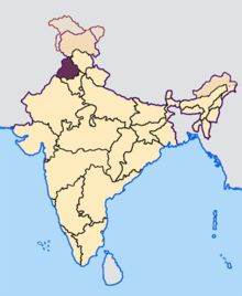
Sahibzada Ajit Singh Nagar district (SAS Nagar district)[1]), also known as Ajitgarh district, is one of the twenty two districts of Punjab a state in north-west India. It was formed in April 2006[2][3] and is 18th district of Punjab, created next to Pathankot district. This district was carved out of areas falling in Ropar and Patiala District.
SAS Nagar is named after the eldest son of Guru Gobind Singh, Sahibzada Ajit Singh which means "House of Sahibzada Ajit Singh".
Community development blocks in the district
Kharar block
This block consists of 154 villages and 2 towns namely Ajitgarh and Kharar and there 4 un-inhabited villages. As per 2001 census the total population of the block is 369,798. The rural population of the block is 196,044 out of which there are 106,688 males and 89,356 females. The total S.C. Population in the rural area is 55,544. The block is having total area of 411.32 km2. Out of which the rural area covers 383.26 km2.
Under the service area approach, all the villages have been allocated among 17 branches of commercial banks and 4 branches of RPBs. There are total 86 branches are functioning in the block which comprises 57 commercial banks, 13 private banks. 11 Coop. Banks, 4 Punjab Gramin Banks and 1 Agricultural Development bank. S.A.S. Nagar has emerged as an Industrial Focal Point and designated as District Headquarters. It has become a satellite town of Chandigarh and has registered a fast rate of growth.
Majri block
Majri Block comprises 116 villages out of which 1 village is un-inhabited. This block forms part of Kharar sub division. The total population of the block is 111,598 as per 2001 census. The population in rural area is 88551, out of which 47,892 are males and 40,659 are female. The S.C. population in rural area is 25,531. Kurali is the only town in the block and has population of 23,047. This block is spread over an area 274.84 km2. The block comes under dark category. All the villages numbering 116 have been allocated among 8 branches of commercial banks and one branch of P.G.B.. There are 16 branches operating in this block which comprises 9 branches of commercial banks. 1 Pvt. Sector Bank, One branch of PGB and SAS Nagar central co-operative bank is having 5 branches. Due to certain incentives being initiated by the Govt. many large and small-scale industrial units have been established around Kurali.
Dera bassi block
This block consists of 144 villages and 2 towns namely Zirakpur and Dera Bassi and there are 6 un-inhabited villages. As per 2001 census the total population of the block is 216,921. The rural population of the block is 170192 out of which there are 93,116 males and 77,076 females. The total S.C. population lin the rural area is 48,683. This block is having total area of 406.48 km2. Out of which the rural area covers 371.17 km2. Dera Bassi block has a good number of small scale units. Chemical paints, Steel tubes, plywood, handlooms and kntting of daris are some of the industries which have koffered good employment to a number of persons. The soil of the block is sandy to sandy loam. There are total 25 branches are functioning in the block which comprises 19 commercial banks, 1 private banks, 3 coop. banks, 1 Malwa Gramin Bank & 1 agricultural development bank. Zirakpur and had a very fast development and has become a part of Greater Chandigarh.
Areas in SAS Nagar district
Areas within the district include:
Demographics
According to the 2011 census, SAS Nagar district has a population of 986,147,[4] roughly equal to the nation of Fiji[5] or the US state of Montana.[6] This gives it a ranking of 450th in India (out of a total of 640).[4] The district has a population density of 830 inhabitants per square kilometre (2,100/sq mi) .[4] Its population growth rate over the decade 2001-2011 was 32.02%.[4] SAS Nagar has a sex ratio of 878 females for every 1,000 males,[4] and a literacy rate of 84.9%.[4]
References
- ↑ It’s Sahibzada Ajit Singh Nagar, not Ajitgarh: DC: Retrieved from The Tribune: Nov 28 2014
- ↑ SAS Nagar to become a district: Retrieved from The Tribune: 20060228
- ↑ "About NIC District Centre S.A.S. NAGAR (MOHALI)".
- 1 2 3 4 5 6 "District Census 2011". Census2011.co.in. 2011. Retrieved 2011-09-30.
- ↑ US Directorate of Intelligence. "Country Comparison:Population". Retrieved 2011-10-01.
Fiji 883,125 July 2011 est.
- ↑ "2010 Resident Population Data". U. S. Census Bureau. Retrieved 2011-09-30.
Montana 989,415
- ↑ http://www.census2011.co.in/census/district/605-mohali.html

| Topics |
|  |
|---|---|---|
| Regions | ||
| Districts | ||
| Major Cities | ||