Ait Irane
| Aït Irane ⴰⵉⵜ ⵉⵔⴰⵏⴻ آيت إيران | ||
|---|---|---|
| Village | ||
|
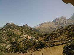
View of the Djurdjura Range | ||
| ||
| Nickname(s): Ath Yiran or At Yiran | ||
_location_map.svg.png) | ||
 Aït Irane | ||
| Coordinates: DZ 36°30′00″N 4°01′00″E / 36.5°N 4.016667°E | ||
| Country |
| |
| Province | Tizi Ouzou | |
| District | Ouadhia | |
| Communes | Aït Bouaddou | |
| Elevation | 2,766 ft (843 m) | |
| Population (2010[1]) | ||
| • Total | 1,173 | |
| Time zone | CET (UTC+1) | |
Aït Irane (Taqbaylit: [ath yir'en]), ath yirane (in kabyle) ⴰⵉⵜ ⵉⵔⴰⵏⴻ in Tifinagh, means izmawen, is one of the villages that belong to the commune Aït Bouadou, also called Ath Vouvaddou or Beni Bouaddou. Aït Bouadou is a commune of the Ouadhia District (Daïra) which is a Tizi Ouzou Province (Wilaya) in the Kabylie region of Algeria.
Climate
Aït Irane has a hot, temperate climate. The village has an average yearly temperature of 15.4 °C. The hottest month of the year is August, reaching an average temperature of 26.2 °C. In January, the average temperature is 7.0 °C. Rainfall averages 921 mm.
The minimum average rainfall is in July with only 4 mm. In January, rainfall is the heaviest, with an average of 149 mm.
The rainfall variations between the moistest month and the dryest month is 145 mm. Yearly Temperature Variation is 19.2 °C.[2]
Villages
Aït Bouaddou consists of nine villages:[3]
- Aït Amar
- Aït Djemaa, Commune Headquarter
- Aït Khalfa
- Ait Irane, at the altitude of 813 meters.
- Aït Ouel Hadj
- Aït Maalem
- Ibadissen
- Takherradjit
- Tamkarbout
See also
Notes and references
- ↑ Evolution intercensitaire de la population sur le site de la wilaya de Tizi Ouzou. Consult 02/25/2011
- ↑ Climat: Ait Irane, consultation 04/13/2016
- ↑ Journal officiel de la République Algérienne, 19 décembre 1984.
