Ain Aata
| Ain Aata Ain Ata, 'Ain 'Ata, Ayn Aata | |
|---|---|
| Village | |
| Country |
|
| Governorate | Beqaa Governorate |
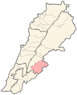
| District | Rashaya District |
| Area | |
| • Total | 22.40 sq mi (58.02 km2) |
| Elevation | 4,360 ft (1,330 m) |
 Shown within Lebanon | |
| Alternate name | Ain Aata, 'Ain 'Ata, Ayn Aata |
|---|---|
| Location | 99 kilometres (62 mi) east of Beirut |
| Region | Rashaya |
| Coordinates | 33°26′11″N 35°46′46″E / 33.436390°N 35.779446°E |
| History | |
| Cultures | Roman |
| Site notes | |
| Condition | Ruins |
| Public access | Yes |
Ain Aata, Ain Ata, 'Ain 'Ata or Ayn Aata is a village and municipality situated southwest of Rashaya, 99 kilometres (62 mi) south-east of Beirut, in the Rashaya District of the Beqaa Governorate in Lebanon.[1]
The name is thought to mean "gift spring".[2] There is a remarkably cold spring in the area.[3]
The village was suggested by Charles William Meredith van de Velde to be the ancient site of Beth-Anath or Anatha mentioned in the Bible Book of Joshua (Joshua 19:38) and the Book of Judges (Judges 1:33) as a land given to Naphtali, where the local canaanites were subjugated to forced labor by the elite of the Israelite tribe. Eusebius in his work Onomasticon, placed it 9 miles (14 km) from Dora (Tanturah), however this falls outside the territory of Naphtali.[1][4] Beth-Anath has been translated to mean "temple of Anat", a canaanite goddess linked to a Sumerian predecessor called Ninhursag.[5]
Roman temple
Recent epigraphic surveys have confirmed the ruins of a Roman temple and cult site in the village that are included in a group of Temples of Mount Hermon.[6][7][8][9] Foundations and columns of a ruined temple complex in the woods near the village were recorded by William McClure Thomson, who thought them to have once been called Kubrikha. He remarked that "the whole neighborhood is crowded with ancient but deserted sites."[4]
-
_p177_CEDARS.jpg)
Cedars, in the hills of Ain Aata (2 June 1860)[1]
- ^ Cite error: The named reference
Harveywas invoked but never defined (see the help page).
References
- 1 2 John Kitto (1 June 2003). Encyclopedia of Biblical Literature. Kessinger Publishing. pp. 344–. ISBN 978-0-7661-5979-2. Retrieved 22 September 2012.
- ↑ Royal Geographical Society (Great Britain) (1837). The journal of the Royal Geographical Society of London. J. Murray. pp. 98–. Retrieved 22 September 2012.
- ↑ Annie Jane Harvey. Our Cruise in the Claymore, with a Visit to Damascus and the Lebanon. Elibron.com. pp. 145–. ISBN 978-1-4021-3492-0. Retrieved 22 September 2012.
- 1 2 William McClure Thomson (1859). The Land and the Book: or, Biblical illustrations drawn from the manners and customs, the scenes and scenery, of the Holy Land. Harper & brothers. pp. 315–. Retrieved 22 September 2012.
- ↑ Nadav Naʼaman (2005). Canaan in the 2nd Millennium B.C.E. Eisenbrauns. pp. 248–. ISBN 978-1-57506-113-9. Retrieved 22 September 2012.
- ↑ Ted Kaizer (2008). Aliquot, Julien., Sanctuaries and villages on Mount Hermon in the Roman period in The Variety of Local Religious Life in the Near East In the Hellenistic and Roman Periods. BRILL. pp. 76–. ISBN 978-90-04-16735-3. Retrieved 17 September 2012.
- ↑ Mouterde, R. (1951–1952). "Antiquités de l'Hermon et de la Beqâ". Mélanges de l'Université St. Joseph. 29: 19–89.
- ↑ Edward Robinson; Eli Smith (1857). Later Biblical researches in Palestine, and in the adjacent regions: a journal of travels in the year 1852. Crocker and Brewster. pp. 438–. Retrieved 22 September 2012.
- ↑ Arthur Penrhyn Stanley (1871). Sinai and Palestine: in connection with their history. J. Murray. pp. 408–. Retrieved 22 September 2012.
External links
- Ain Aata on Localiban
- 'Ain 'Ata on geographic.org
- Photos of Roman temples in the Rashaya area on the American University of Beirut website
- Roman Temples on discoverlebanon.com
- Ain Ata on wikimapia
- Ain Ata on geody.com
- Hebrew concordance entry for Beth-Anath, "Temple of Anat"
Capital: Rashaya | ||
| Towns and villages |
|  |