Bad Neuenahr-Ahrweiler
| Bad Neuenahr-Ahrweiler | ||
|---|---|---|
 | ||
| ||
 Bad Neuenahr-Ahrweiler | ||
Location of Bad Neuenahr-Ahrweiler within Ahrweiler district 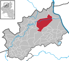
 | ||
| Coordinates: 50°32′41″N 7°6′48″E / 50.54472°N 7.11333°ECoordinates: 50°32′41″N 7°6′48″E / 50.54472°N 7.11333°E | ||
| Country | Germany | |
| State | Rhineland-Palatinate | |
| District | Ahrweiler | |
| Government | ||
| • Mayor | Guido Orthen (CDU) | |
| Area | ||
| • City | 63.38 km2 (24.47 sq mi) | |
| Population (2015-12-31)[1] | ||
| • City | 27,468 | |
| • Density | 430/km2 (1,100/sq mi) | |
| • Metro | 27,487 | |
| Time zone | CET/CEST (UTC+1/+2) | |
| Postal codes | 53474 | |
| Dialling codes | 02641; 02646 | |
| Vehicle registration | AW | |
| Website | www.bad-neuenahr-ahrweiler.de | |

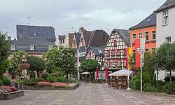
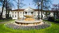
Bad Neuenahr-Ahrweiler is a renowned spa town in the German Bundesland of Rhineland-Palatinate that serves as the capital of the Ahrweiler district. The A61 motorway connects the town with cities like Cologne and Mainz. Formed by the merging of the towns (now districts) of Bad Neuenahr and Ahrweiler in 1969, Bad Neuenahr-Ahrweiler consists of 11 such districts.
Geography
Bad Neuenahr-Ahrweiler rests in the Ahr valley (German: Ahrtal) on the left bank of the Rhine river in the north of Rhineland-Palatinate. Bad Neuenahr-Ahrweiler nestles in the Ahr Hills (German: Ahrgebirge).
The highest hill in the area is the Häuschen at 506 metres (1,660 ft) metres above sea level. Nearby are the hills of Steckenberg, Neuenahrer, and Talerweiterung. There used to be castles on the last two of these hills.
Neighbouring communities
Bad Neuenahr-Ahrweiler is surrounded by the following villages and towns (clockwise from the north): Grafschaft, Remagen, Sinzig, Königsfeld, Rhineland-Palatinate, Schalkenbach, Heckenbach, Kesseling, Rech and Dernau. The nearest cities are Bonn and Koblenz.
Districts
Bad Neuenahr is divided into Ortsbezirke which consist of one or more districts. The Ortsbezirke be represented by local councils. The largest district, Bad Neuenahr, was originally made up of three communities, which are still seen as districts.
Population statistics as of 31 March 2013 (main and secondary residence):[2]
| Local District | Subdivision | Population (30 June 2015) |
|---|---|---|
| Ahrweiler | District: Ahrweiler | 7,411 |
| Bachem | District: Bachem | 1,214 |
| Bad Neuenahr | Districts: Beul, Hemmessen and Wadenheim | 12,132 |
| Gimmigen | District: Gimmigen | 735 |
| Heimersheim | District: Heimersheim and Ehlingen | 3,194 |
| Heppingen | District: Heppingen | 873 |
| Kirchdaun | District: Kirchdaun | 368 |
| Lohrsdorf | District: Lohrsdorf and Green | 672 |
| Ramersbach | District: Ramersbach | 567 |
| Walporzheim | District: Walporzheim and Mareinthal | 698 |
History
Antiquity
Discoveries dating to Hallstatt period (1000-500 BC) shows farming activity by local Celts that dwelled in the area. The Gallic Wars (58–50 BC) resulted in the forced relocation of the indigenous Eburones people to the Middle Rhine. From the 1st to 3rd Century, several Roman discoveries were made. Most notable is the Villa Rustica of Bad Neuenahr.
Middle Ages
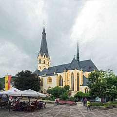
In 893 AD, Ahrweiler was mentioned as Arwilre, Arewilre, Arewilere, and later Areweiller in the Prüm Urbar (register of estates owned by Prüm Abbey). The abbey of Ahrweiler owned a manor with 24 farmsteads; 50 acres of farmland and 76 acres of vineyards. The first mention of a parish church occurred in Neuenahr Castle and surrounding county (Newenare) from 1204 to 1225.
Twin towns
Economy
- The German Army's (German: Deutsches Heer) Logistics Centre (main depot) is located in an underground facility.
- Bad Neuenahr-Ahrweiler has been home to the traditional mineral water "Heppinger" since 1584.
- The "Apollinaris" mineral water company was founded in Bad Neuenahr in 1852.
Sport
- Bad Neuenahr-Ahrweiler is the home of the successful women's soccer team, SC 07 Bad Neuenahr.
Born in Bad Neuenahr
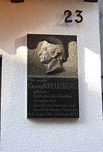
- Georg Kreuzberg (1796-1873), who discovered the source of the Apollinaris mineral fountain
- Cyrillus Jarre (1878-1952), Franciscan Martyrs Archbishop in Jinan / China
- Markus Stenz (born 1965), conductor
- Björn Glasner (born 1973), cyclist
- Jan van Eijden (born 1976), cyclist
- Pierre Kaffer (born 1976), racing driver
- Bianca Rech (born 1981), football player
References
External links
- Bad Neuenahr-Ahrweiler official website
| Wikimedia Commons has media related to Bad Neuenahr-Ahrweiler. |
| Wikivoyage has a travel guide for Bad Neuenahr-Ahrweiler. |