Agolada
| Concello de Agolada | ||
|---|---|---|
| municipality | ||
| ||
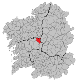 Location of Agolada within Galicia | ||
| Coordinates: 42°45′44″N 8°1′11″W / 42.76222°N 8.01972°WCoordinates: 42°45′44″N 8°1′11″W / 42.76222°N 8.01972°W | ||
| Parroquias | 24 | |
| Government | ||
| • Alcalde (Mayor) | Manuel Costa Casares | |
| Area | ||
| • Total | 147.8 km2 (57.1 sq mi) | |
| Population (2004) | ||
| • Total | 3,678 | |
| • Density | 24.88/km2 (64.4/sq mi) | |
| (INE) | ||
| Time zone | CET (UTC+1) | |
| • Summer (DST) | CET (UTC+2) | |
Agolada is a municipality in Galicia, Spain in the province of Pontevedra.
Population

Administration
It is divided into 24 parishes with many different patron saints. They are: Agra (San Miguel), Artoño (Santalla), A Baíña (San Pedro), Basadre (Santa María), Berredo (Santa María), Borraxeiros (San Cristovo), Brántega (San Lourenzo), Brocos (San Miguel), Carmoega (San Pedro), Eidián (Santiago), Esperante (San Cibrao), Ferreiroa (San Pedro), Gurgueiro (San Miguel), Merlín (San Pedro), Órrea (Santo André), Ramil (San Martiño), San Paio de Bais (San Paio), Santa Comba (San Xoán), Sesto (San Cibrao), O Sexo (Santiago), As Trabancas (San Mamede), Val de Sangorza (Santa María), Ventosa (San Xulián), Vilariño (Santa María).
This article is issued from Wikipedia - version of the 3/19/2015. The text is available under the Creative Commons Attribution/Share Alike but additional terms may apply for the media files.