African easterly jet
The African easterly jet, is a region of the lower troposphere over West Africa where the seasonal mean wind speed is maximum and easterly. Forming due to the temperature contrast between the Sahara Desert and the Gulf of Guinea, maximum wind speeds are located at a height of 3 kilometres (1.9 mi) to the north of the monsoon trough. The jet marches northward from its southern location in January, reaching its most northerly latitude in August, and its strongest winds in September while shifting back towards the equator. Within the easterly jet, tropical waves form. Convective complexes associated with these waves can form tropical cyclones. If the feature is suppressed south of its normal location during August and September, tropical cyclogenesis is suppressed. If desertification continues across Sub-Saharan Africa, the strength of this feature would increase, though tropical wave generation is expected to decrease which could decrease the number of tropical cyclones in the Atlantic basin.
Formation and characteristics
During January, it lies at 3,000 metres (9,800 ft) above sea level at the latitude of five degrees north. Winds within it rise from 30 km/h (19 mph) in January to 40 km/h (25 mph) in March. Shifting northward in April to the seventh parallel, winds within the jet increase to 45 km/h (28 mph). By June, it shifts northward into northwest Africa.[1] The mid-level African easterly jet occurs during the Northern Hemisphere summer between 10°N and 20°N above West Africa, and the nocturnal poleward low-level jet occurs in the Great Plains of east and South Africa.[2] The formation of the thermal low over northern Africa leads to a low-level westerly jet stream from June into October to the south of the Intertropical Convergence Zone.[3] The jet develops because heating of the West African land mass during the Northern Hemisphere summer creates a surface temperature and moisture gradient between the Gulf of Guinea and the Sahara, and the atmosphere responds by generating vertical wind shear to maintain thermal wind balance. The jet reaches its zenith in August, lying between the 16th and 17th parallels. In September, winds maximize near 50 km/h (31 mph) between the 12th and 13th parallels. The easterly jet weakens and drops southward during October and November.[1]
Impact
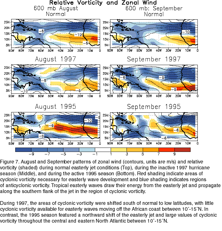
The low-level easterly African jet stream is considered to play a crucial role in the southwest monsoon of Africa,[4] and helps form the tropical waves which march across the tropical Atlantic and eastern Pacific oceans during the warm season.[5] The jet exhibits both barotropic and baroclinic instability, which produces synoptic scale, westward propagating disturbances in the jet known as African easterly waves, or tropical waves. A small number of mesoscale storm systems embedded in these waves develop into tropical cyclones after they move from west Africa into the tropical Atlantic, mainly during August and September. When it lies south of normal during the peak months of the Atlantic hurricane season, tropical cyclone formation is suppressed.[6]
Role during climate changes
If sub-Saharan Africa becomes a desert, the African easterly jet is expected to increase in strength. However, related tropical wave activity is expected to decrease,[7] as the African easterly jet should decrease in latitude during the summer months due to the drier conditions in western Africa.
References
- 1 2 Marcel Leroux (2001). The Meteorology and Climate of Tropical Africa. Springer. pp. 138–139. ISBN 978-3-540-42636-3. Retrieved 2011-02-05.
- ↑ Dr. Alex DeCaria. Lesson 4 – Seasonal-mean Wind Fields. Retrieved on 2008-05-03.
- ↑ B. Pu and K. H. Cook (2008). Dynamics of the Low-Level Westerly Jet Over West Africa. American Geophysical Union, Fall Meeting 2008, abstract #A13A-0229. Retrieved on 2009-03-08.
- ↑ Kerry H. Cook. Generation of the African Easterly Jet and Its Role in Determining West African Precipitation. Retrieved on 2008-05-08.
- ↑ Chris Landsea. AOML Frequently Asked Questions. Subject: A4) What is an easterly wave ? Retrieved on 2008-05-08.
- ↑ Climate Prediction Center (November 1997). "Figure 7". National Oceanic and Atmospheric Administration. Retrieved 2011-02-05.
- ↑ Pak Sum Low (2005). Climate Change and Africa. Cambridge University Press. p. 43. ISBN 978-0-521-83634-0. Retrieved 2011-02-05.
Further reading
- Cook, Kerry H.: Generation of the African Easterly Jet and Its Role in Determining West African Precipitation.
- Holton, James R.: An Introduction to Dynamic Meteorology, 2004. ISBN 0-12-354015-1