Aeolian processes

Aeolian processes, also spelled eolian or æolian, pertain to wind activity in the study of geology and weather and specifically to the wind's ability to shape the surface of the Earth (or other planets). Winds may erode, transport, and deposit materials and are effective agents in regions with sparse vegetation, a lack of soil moisture and a large supply of unconsolidated sediments. Although water is a much more powerful eroding force than wind, aeolian processes are important in arid environments such as deserts.
The term is derived from the name of the Greek god Aeolus, the keeper of the winds.
Wind erosion


Wind erodes the Earth's surface by deflation (the removal of loose, fine-grained particles by the turbulent action of the wind) and by abrasion (the wearing down of surfaces by the grinding action and sandblasting of windborne particles).
Regions which experience intense and sustained erosion are called deflation zones. Most aeolian deflation zones are composed of desert pavement, a sheet-like surface of rock fragments that remains after wind and water have removed the fine particles. Almost half of Earth's desert surfaces are stony deflation zones. The rock mantle in desert pavements protects the underlying material from deflation.
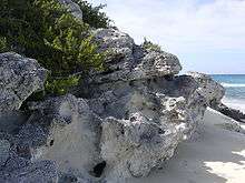
A dark, shiny stain, called desert varnish or rock varnish, is often found on the surfaces of some desert rocks that have been exposed at the surface for a long period of time. Manganese, iron oxides, hydroxides, and clay minerals form most varnishes and provide the shine.
Deflation basins, called blowouts, are hollows formed by the removal of particles by wind. Blowouts are generally small, but may be up to several kilometers in diameter.
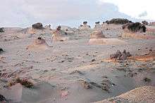
Wind-driven grains abrade landforms. In parts of Antarctica wind-blown snowflakes that are technically sediments have also caused abrasion of exposed rocks.[1] Grinding by particles carried in the wind creates grooves or small depressions. Ventifacts are rocks which have been cut, and sometimes polished, by the abrasive action of wind.
Sculpted landforms, called yardangs, are up to tens of meters high and kilometers long and are forms that have been streamlined by desert winds. The famous Great Sphinx of Giza in Egypt may be a modified yardang.
Transport


Particles are transported by winds through suspension, saltation (skipping or bouncing) and creeping (rolling or sliding) along the ground.
Small particles may be held in the atmosphere in suspension. Upward currents of air support the weight of suspended particles and hold them indefinitely in the surrounding air. Typical winds near Earth's surface suspend particles less than 0.2 millimeters in diameter and scatter them aloft as dust or haze.
Saltation is downwind movement of particles in a series of jumps or skips. Saltation normally lifts sand-size particles no more than one centimeter above the ground and proceeds at one-half to one-third the speed of the wind. A saltating grain may hit other grains that jump up to continue the saltation. The grain may also hit larger grains that are too heavy to hop, but that slowly creep forward as they are pushed by saltating grains. Surface creep accounts for as much as 25 percent of grain movement in a desert.
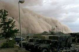
Aeolian turbidity currents are better known as dust storms. Air over deserts is cooled significantly when rain passes through it. This cooler and denser air sinks toward the desert surface. When it reaches the ground, the air is deflected forward and sweeps up surface debris in its turbulence as a dust storm.
Crops, people, villages, and possibly even climates are affected by dust storms. Some dust storms are intercontinental, a few may circle the globe, and occasionally they may engulf entire planets. When the Mariner 9 spacecraft entered its orbit around Mars in 1971, a dust storm lasting one month covered the entire planet, thus delaying the task of photo-mapping the planet's surface.[2]
Most of the dust carried by dust storms is in the form of silt-size particles. Deposits of this windblown silt are known as loess. The thickest known deposit of loess, 335 meters, is on the Loess Plateau in China. This very same Asian dust is blown for thousands of miles, forming deep beds in places as far away as Hawaii.[3] In Europe and in the Americas, accumulations of loess are generally from 20 to 30 meters thick.
Aeolian transport from deserts plays an important role in ecosystems globally, e.g. by transport of minerals from the Sahara to Amazonia.[4] Saharan dust is also responsible for forming red clay soils in southern Europe.[5] Aeolian processes are affected by human activity, such as the use of 4x4 vehicles.[6]
Small whirlwinds, called dust devils, are common in arid lands and are thought to be related to very intense local heating of the air that results in instabilities of the air mass. Dust devils may be as much as one kilometer high.
Deposition


Wind-deposited materials hold clues to past as well as to present wind directions and intensities. These features help us understand the present climate and the forces that molded it. Wind-deposited sand bodies occur as sand sheets, ripples, and dunes.
Sand sheets are flat, gently undulating sandy plots of sand surfaced by grains that may be too large for saltation. They form approximately 40 percent of aeolian depositional surfaces. The Selima Sand Sheet in the eastern Sahara Desert, which occupies 60,000 square kilometers in southern Egypt and northern Sudan, is one of the Earth's largest sand sheets. The Selima is absolutely flat in a few places; in others, active dunes move over its surface.
Wind blowing on a sand surface ripples the surface into crests and troughs whose long axes are perpendicular to the wind direction. The average length of jumps during saltation corresponds to the wavelength, or distance between adjacent crests, of the ripples. In ripples, the coarsest materials collect at the crests causing inverse grading. This distinguishes small ripples from dunes, where the coarsest materials are generally in the troughs. This is also a distinguishing feature between water laid ripples and aeolian ripples.
Wind-blown sand moves up the gentle upwind side of the dune by saltation or creep. Sand accumulates at the brink, the top of the slipface. When the buildup of sand at the brink exceeds the angle of repose, a small avalanche of grains slides down the slipface. Grain by grain, the dune moves downwind.
Accumulations of sediment blown by the wind into a mound or ridge, dunes have gentle upwind slopes on the windward side. The downwind portion of the dune, the lee slope, is commonly a steep avalanche slope referred to as a slipface. Dunes may have more than one slipface. The minimum height of a slipface is about 30 centimeters.
Some of the most significant experimental measurements on aeolian sand movement were performed by Ralph Alger Bagnold, a British engineer who worked in Egypt prior to World War II. Bagnold investigated the physics of particles moving through the atmosphere and deposited by wind. He recognized two basic dune types, the crescentic dune, which he called "barchan," and the linear dune, which he called longitudinal or "seif" (Arabic for "sword").
A 2011 study published in Catena examined the effect of vegetation on aeolian dust accumulation in the semiarid steppe of northern China. Using a series of trays with different vegetation coverage and a control model with none, the authors found that an increase in vegetation coverage improves the efficiency of dust accumulation and adds more nutrients to the environment, particularly organic carbon. Two critical point were revealed by their data: 1. the efficiency of trapping dust increases slowly above 15% coverage, and decreases rapidly below 15% coverage. 2. at around 55%-75% coverage, dust accumulation reaches a maximum capacity.[7]
A three year quantitative study on the effects of vegetation removal on wind erosion found that the removal of grasses in an aeolian environment increased the rate of soil deposition. In the same study, a relationship was shown between decreasing plant density with decreasing soil nutrients. Similarly, horizontal soil flux across the test site was shown to increase with increasing vegetation removal.[8]
A 1998 study published in Earth Surfaces Processes and Landforms investigated the relationship between vegetative cover on sand surfaces with the rate of sand transport. It was found that sand flux decreased exponentially with vegetation cover. This was done by measuring plots of land with varying degrees of vegetation against rates of sand transport. The authors contend that this relationship can be utilized to manipulate rates of sediment flux by introducing vegetation in an area or to quantify human impact by recognizing vegetation loss’s affect on sandy landscapes.[9]
See also
References
- ↑ National Geographic Almanac of Geography, 2005, page 166, ISBN 0-7922-3877-X.
- ↑ Hsui, Albert T. (2001). "Geology of Mars: Aeolian". Retrieved 2012-09-30.
- ↑ Kurtz, Andrew C; Derry, Louis A; Chadwick, Oliver A (2001). "Accretion of Asian dust to Hawaiian soils: isotopic, elemental, and mineral mass balances" (PDF). Geochimica et Cosmochimica Acta. 65 (12): 1971–1983. doi:10.1016/S0016-7037(01)00575-0. ISSN 0016-7037. Retrieved January 14, 2016.
- ↑ Koren, Ilan; Kaufman, Yoram J; Washington, Richard; Todd, Martin C; Rudich, Yinon; Martins, J Vanderlei; Rosenfeld, Daniel (2006). "The Bodélé depression: a single spot in the Sahara that provides most of the mineral dust to the Amazon forest". Environmental Research Letters. 1 (1): 014005. doi:10.1088/1748-9326/1/1/014005. ISSN 1748-9326. Retrieved January 14, 2016.
- ↑ "African dust caused red soil in southern Europe". Spanish Foundation for Science and Technology. November 11, 2010. Retrieved November 2, 2012.
- ↑ Retta, A.; Wagner, L.E.; Tatarko, J. (2014). "Military Vehicle Trafficking Impacts on Vegetation and Soil Bulk Density at Fort Benning, Georgia" (PDF). Transactions of the ASABE. 57 (4): 1043–1055. doi:10.13031/trans.57.10327. ISSN 2151-0032. Retrieved January 14, 2016.
- ↑ Yan, Yuchun; Xu, Xingliang; Xin, Xiaoping; Yang, Guixia; Wang, Xu; Yan, Ruirui; Chen, Baorui (2011-12-01). "Effect of vegetation coverage on aeolian dust accumulation in a semiarid steppe of northern China". CATENA. 87 (3): 351–356. doi:10.1016/j.catena.2011.07.002.
- ↑ Li, Junran; Okin, Gregory S.; Alvarez, Lorelei; Epstein, Howard (2007-08-08). "Quantitative effects of vegetation cover on wind erosion and soil nutrient loss in a desert grassland of southern New Mexico, USA". Biogeochemistry. 85 (3): 317–332. doi:10.1007/s10533-007-9142-y. ISSN 0168-2563.
- ↑ Lancaster, Nicholas; Baas, Andy (1998-01-01). "Influence of vegetation cover on sand transport by wind: field studies at Owens Lake, California". Earth Surface Processes and Landforms. 23 (1): 69–82. doi:10.1002/(SICI)1096-9837(199801)23:13.0.CO;2-G. ISSN 1096-9837.
External links
- The Bibliography of Aeolian Research
- Facts about wind erosion and dust storms on the Great Plains, hosted by the UNT Government Documents Department
- Aeolian Research (the Journal)
- International Society for Aeolian Research, ISAR
- "Eolian Processes". USGS. 1997. Archived from the original on 1 December 2006. Retrieved 2006-11-01.
Geologic principles and processes | ||
|---|---|---|
| Stratigraphic principles | 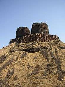 | |
| Petrologic principles | ||
| Geomorphologic processes | ||
| Sediment transport | ||