Administrative divisions of Poland
 |
| Administrative divisions of Poland |
|---|
|
Voivodeships Powiats (list) Gminas (list) |
The administrative division of Poland since 1999 has been based on three levels of subdivision. The territory of Poland is divided into voivodeships (provinces); these are further divided into powiats (counties or districts), and these in turn are divided into gminas (communes or municipalities). Major cities normally have the status of both gmina and powiat. Poland currently has 16 voivodeships, 379 powiats (including 65 cities with powiat status), and 2,479 gminas.[1]
The current system was introduced pursuant to a series of acts passed by the Polish parliament in 1998, and came into effect on 1 January 1999. Previously (in the period from 1975 to 1998) there had been 49 smaller voivodeships, and no powiats (see Administrative division of the People's Republic of Poland). The reform created 16 larger voivodeships (largely based on and named after historical regions) and reintroduced powiats.
The boundaries of the voivodeships do not always reflect the historical borders of Polish regions. Around half of the Silesian Voivodeship belongs to the historical province of Lesser Poland. Similarly the area around Radom, which historically is part of Lesser Poland, is located in the Masovian Voivodeship. Also, the Pomeranian Voivodeship includes only the eastern extreme of historical Pomerania, as well as areas outside it.
Voivodeships
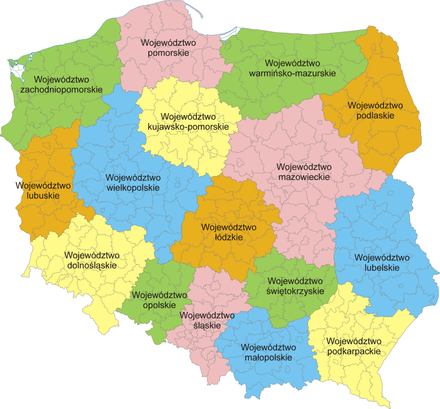
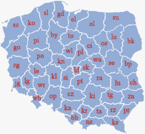
Poland is currently divided into 16 provinces known as voivodeships (Polish: województwa, singular województwo). Administrative authority at voivodeship level is shared between a central government-appointed governor, called the voivode (usually a political appointee), an elected assembly called the sejmik, and an executive chosen by that assembly. The leader of that executive is called the marszałek.
# Voivodeship Polish name Capital city (cities) 1 Greater Poland wielkopolskie Poznań 2 Kuyavia-Pomerania kujawsko-pomorskie Bydgoszcz and Toruń 3 Lesser Poland małopolskie Kraków 4 Łódź łódzkie Łódź 5 Lower Silesia dolnośląskie Wrocław 6 Lublin lubelskie Lublin 7 Lubusz lubuskie Gorzów Wielkopolski and Zielona Góra 8 Masovia mazowieckie Warsaw 9 Opole opolskie Opole 10 Podlaskie podlaskie Białystok 11 Pomerania pomorskie Gdańsk 12 Silesia śląskie Katowice 13 Subcarpathia podkarpackie Rzeszów 14 Holy Cross Province świętokrzyskie Kielce 15 Warmia-Masuria warmińsko-mazurskie Olsztyn 16 West Pomerania zachodniopomorskie Szczecin
Powiats
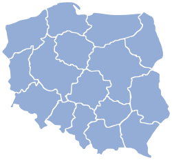
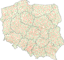
Each voivodeship is divided into a number of smaller entities known as powiats (counties). The number of powiats per voivodeship ranges from 12 (Opole Voivodeship) to 42 (Masovian Voivodeship). This includes both powiats proper (known as land counties, Polish powiaty ziemskie), and cities with powiat status (city counties, Polish powiaty grodzkie or more formally miasta na prawach powiatu). Land counties have an elected council (rada powiatu), which elects an executive headed by the starosta. In city counties the functions of these institutions are performed by the city's own council and executive.
Gminas
The third level of administrative division is the gmina (also called commune or municipality). A powiat is typically divided into a number of gminas (between 3 and 19), although the city counties constitute single gminas. A gmina may be classed as urban (consisting of a town or city), urban-rural (consisting of a town together with its surrounding villages and countryside), or rural (not containing a town). A gmina has an elected council as well as a directly elected mayor (known as prezydent in large towns, burmistrz in most urban and urban-rural gminas, and wójt in rural gminas).
Smaller units
Gminas are generally sub-divided into smaller units, called osiedle or dzielnica in towns, and sołectwo in rural areas. However these units are of lesser importance and are subordinate in status to the gmina.
Historical divisions
Polish territory has been subject to significant changes over the course of Polish history. Therefore, the modern Polish administrative division, while on some levels similar to some historical ones, is quite different from others. Historical Polish administrative divisions can be divided into the following periods:
- before 1569: Administrative division of Kingdom of Poland
- 1569-1795: Administrative division of Polish-Lithuanian Commonwealth
- 1795-1807: Administrative division of Polish territories after partitions
- 1807-1815: Administrative division of Duchy of Warsaw
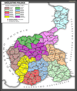
- 1815-1914: Administrative division of Congress Poland
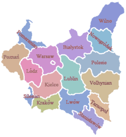
- 1914-1918: Administrative division of Polish territories during WWI
- 1918-1939: Administrative division of Second Polish Republic
- 1939-1945: Administrative division of Polish territories during WWII
- 1945-1999: Administrative division of People's Republic of Poland
- since 1999: see main article above
|


See also
- Administrative division of the Roman Catholic Church in Poland
- Electoral districts of Poland
- Military districts of Poland
- Territorial evolution of Poland
- NUTS of Poland
Cultural and economic:
References
- ↑ "Size and structure of population and vital statistics by territorial division in 2012 (as of December 31)" (PDF) (in Polish). Główny Urząd Statystyczny (Central Statistical Office). May 2013. Retrieved 25 September 2013.
External links
Poland articles | |||||||
|---|---|---|---|---|---|---|---|
| History |  | ||||||
| Geography | |||||||
| Politics | |||||||
| Economy | |||||||
| Society |
| ||||||
| |||||||