Adber
Adber
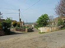
Adber (formerly Eatan) is a hamlet in Dorset, England.[1][2] It is known as Ateberie in the Domesday Book.[3]
Adber has no church. Its position affords fine views over the county of Somerset.
References
- ↑ "Ordnance Survey: 1:50,000 Scale Gazetteer" (csv (download)). Ordnance Survey. 1 January 2016. Retrieved 30 January 2016.
- ↑ Ordnance Survey: Landranger map sheet 183 Yeovil & Frome (Shaftesbury & Shepton Mallet) (Map). Ordnance Survey. 2011. ISBN 9780319228616.
- ↑ Professor J.J.N.Palmer. "Open Doomsday: Adber". Anna Powell-Smith. Retrieved 31 January 2016.
External links
-
 Media related to Adber at Wikimedia Commons
 - Adber in the Domesday Book
Coordinates: 50°58′48″N 2°34′28″W / 50.98000°N 2.57444°W
This article is issued from Wikipedia - version of the 8/17/2016. The text is available under the Creative Commons Attribution/Share Alike but additional terms may apply for the media files.