Achavandra Muir
| Achavandra Muir | |
| Scottish Gaelic: Achadh Anndra | |
 |
|
 Achavandra Muir |
|
| OS grid reference | NH7793 |
|---|---|
| Council area | Highland |
| Country | Scotland |
| Sovereign state | United Kingdom |
| Police | Scottish |
| Fire | Scottish |
| Ambulance | Scottish |
| EU Parliament | Scotland |
Coordinates: 57°55′N 4°04′W / 57.91°N 4.07°W
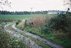
Achavandra Muir (Scottish Gaelic: Achadh Anndra - Andrew's Field) is a hamlet in the Scottish Highlands in northeastern Scotland, about 7 kilometres from the coast. It lies just off the A9 between Dornoch and Loch Fleet.[1][2] The land in the area is dominated by bog and crofting.[3]
Historically, Achavandra Muir was occupied by Father John Sutherland, who died on 23 January 1910.[4] In 1812 there were a reported twenty settlers in Achavandra Muir.[5]

Boggy farm
References
- ↑ Google Maps (Map). Google.
- ↑ Bing Maps (Map). Microsoft and Harris Corporation Earthstar Geographics LLC.
- ↑ Scottish gaelic studies, Volumes 14-15. University of Aberdeen. Celtic Dept, H. Milford, Oxford University Press. 1983. p. 114.
- ↑ Papers by command, Volume 19. Great Britain. Parliament. House of Commons, HMSO. 1913. p. 17.
- ↑ Adam, Robert James. Papers on Sutherland estate management, 1802-1816. Volumes 8-9 of Scottish History Society, printed for the Scottish History Society by T. and A. Constable, 1972.
This article is issued from Wikipedia - version of the 11/5/2016. The text is available under the Creative Commons Attribution/Share Alike but additional terms may apply for the media files.