Achateny
Coordinates: 56°45′20″N 6°02′42″W / 56.755556°N 6.045000°W
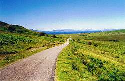
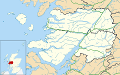
Achateny (Scottish Gaelic: Ach/Achadh an Teine) is a hamlet in Argyll on Ardnamurchan in the Scottish Highlands. It is in the Scottish council area of the Highland, near Branault, along a country lane off the B8007 road several hundred metres from the coast.[1][2] To the east lies the village of Kilmory.
Trees in the area include typical highland birch wood, oaks and rowans and a damp rocky and mossy substrate supporting ferns. Shell sand is also present Achateny with sand dunes. The-low lying land to the west of Achateny is bog.[3] The hamlet contains nothing more than a few scattered dwellings including a white cottage named "Caalmojo".
References
- ↑ Google Maps (Map). Google.
- ↑ Bing Maps (Map). Microsoft and Harris Corporation Earthstar Geographics LLC.
- ↑ The Glasgow naturalist, Volume 20, Parts 1-5. Andersonian Naturalists of Glasgow, Natural History Society of Glasgow. 1980. pp. 314–18.
This article is issued from Wikipedia - version of the 11/5/2016. The text is available under the Creative Commons Attribution/Share Alike but additional terms may apply for the media files.