Achaea Phthiotis
Achaea Phthiotis (Ancient Greek: Ἀχαΐα Φθιῶτις, "Achaea of Phthia") or simply Phthiotis (Φθιῶτις) was a historical region of ancient Greece.
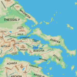
It lay in southeastern Thessaly, between Mount Othrys and the northern shore of the Pagasetic Gulf.[1] Inhabited by perioikoi, it was formally not a part of Thessaly proper but a Thessalian dependency, and had a seat of its own in the Delphic Amphictyony.[1] From 363 BC it came under Boeotian control, but split away during the Lamian War.[1] In the 3rd century BC it became a member of the Aetolian League, until declared free and autonomous by the Roman Republic in 196 BC, following the Second Macedonian War, and re-incorporated into Thessaly.[1]
It has given its name to the modern prefecture of Phthiotis. The Phthiotis Prefecture however lies to the south of the historical region and does not include it. Historical Phthiotis is today part of Magnesia Prefecture.
References
- 1 2 3 4 Kramolisch, Herwig. "Phthiotis". Brill’s New Pauly. Brill Online, 2015. Retrieved 14 February 2016.