Abington Park
Abington Park, in the Abington district of Northampton, has lakes, aviaries, and a museum, as well as trees and grassy open spaces.
The park contains the ruins of the former village of Abington, the site of a medieval manorhouse with a mill attached, mentioned in the Domesday book in 1086. The Abington gallows used for the five hangings in 1612 following the Northamptonshire witch trials, amongst the first in England to use trial by ducking stool, are believed to have been situated at the crossroads in Abington Park.[1] The village was enclosed and depopulated when the manor was enlarged and parklands created by the Thursby family in the late 17th century.[2]
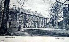
Abington Park Museum

Land for the park was given to the town by Lady Wantage in 1892 and the park was opened to the public in 1897. Two years later, in 1899, Abington Park Museum was opened in the centre of the park.
The museum was originally a manor house built at the turn of the 16th century. The Great Hall, now called the Oak Room because of its oak panelling, dates back to 1500. It was once home to William Shakespeare's granddaughter, Elizabeth Bernard née Elizabeth Hall, who was buried in 1670 in the adjacent late 12th-century church of St Peter and St Paul. Her second marriage was to Sir John Bernard or Barnard, the MP for Huntingdon from 1660, who successively enlarged the house in the 1660s. It passed to the Thursby family in 1669 and was further enlarged and remodelled in the classical Georgian style between 1738 and 1743 by William Thursby. While owned by the Thursbys, the actor David Garrick planted a mulberry tree in the grounds in 1778, in recognition of his friendship with Anne Thursby. In 1821, during repairs to the church, all but the main tower of the church was blown down in a storm; the Thursbys rebuilt the main body of the church, which retains few of its original features.[3][4]
In 1841 the manor was sold and its contents auctioned off. It was converted into a lunatic asylum in 1845, directed first by Thomas Octavius Prichard and later his cousin Thomas Prichard. The asylum was closed in 1892, when the Manor House and grounds were donated by Lady Wantage to Northampton. Successively more and more parts of the house became open to the public. In 1994 the house was reopened as a museum after a complete restoration.
Today the museum features displays about the social and military history of Northampton and Northamptonshire. Exhibits include the Northamptonshire Regiment, local history, and changing exhibits of clothing from its costume collection.
The museum also features displays of leather objects and artifacts from around the world from the collections of the Museum of Leathercraft, a separate organisation.
Park features

Abington Park is home to the annual Green Festival, Kite Festival and occasional fairs. It used to be the venue for the annual 'Folk in the Park' festival until it moved to Delapré Park.
There is usually a selection of brass band, concert band, folk or jazz music to be heard on the bandstand on Sunday afternoons throughout the summer, provided by local groups.
The Park also hosts a small tearoom called The Park Café (formerly known as 'The Old Oak'), which has been under ownership of Tony Ansell since 1981.
The remains of the old village, including two old gate posts, can still be seen within the grounds.
Notes
- ↑ L'Estrange Ewen, C. (2003), Witchcraft and Demonism, Kessinger Publishing, p. 207, ISBN 0766128962
- ↑ Salzman, L. F. (1937), A History of the County of Northampton: Volume 4, pp. 65–69 Parishes: Abington
- ↑ The history of Northampton and its vicinity: brought down to the present time, J. Birdsall, 1831
- ↑ Parker, John Henry (1849), Architectural notices of the churches of the archdeaconry of Northampton: Deaneries of Higham Ferrers and Haddon
References
- History of Abington Park Manor House
- Higgins, Sophia Elizabeth (1903), The Bernards of Abington and Nether Winchendon; a family history, Vol. I, Longmans, Green and co
- Meirion-Jones, G.I.; Pilcher, J.R.; Guibal, F.; Heward, J.; Taylor, R. (1987), "The Dating by Dendrochronology of Three Northamptonshire Halls", Vernacular Architecture, 18: 34–40
External links
- Abington Park Museum - official site
- Museum of Leathercraft
The Borough of Northampton | |||||||||||||||||||
|---|---|---|---|---|---|---|---|---|---|---|---|---|---|---|---|---|---|---|---|
| Suburbs and villages |  | ||||||||||||||||||
| Governance | |||||||||||||||||||
| Culture |
| ||||||||||||||||||
| Education | |||||||||||||||||||
| Sport |
| ||||||||||||||||||
| Transport | |||||||||||||||||||
| |||||||||||||||||||
Coordinates: 52°14′51″N 0°51′52″W / 52.24750°N 0.86444°W