Abertillery
| Abertillery | |
| Welsh: Abertyleri | |
 The view towards Abertillery from the head of the Tyleri |
|
 Abertillery |
|
| Population | 11,601 (2011 census)[1] |
|---|---|
| OS grid reference | SO215045 |
| Principal area | Blaenau Gwent |
| Ceremonial county | Gwent |
| Country | Wales |
| Sovereign state | United Kingdom |
| Post town | ABERTILLERY |
| Postcode district | NP13 |
| Dialling code | 01495 |
| Police | Gwent |
| Fire | South Wales |
| Ambulance | Welsh |
| EU Parliament | Wales |
| UK Parliament | Blaenau Gwent |
| Welsh Assembly | Blaenau Gwent |
|
|
Coordinates: 51°44′N 3°08′W / 51.73°N 3.13°W
Abertillery (/ˌæbərtᵻˈlɛəri/; Welsh: Abertyleri, meaning mouth of the River Tyleri) is the largest town of the Ebbw Fach valley in what was the historic county of Monmouthshire, South Wales. Following local government reorganisation it became part of the Blaenau Gwent County Borough administrative area.
The surrounding landscape borders the Brecon Beacons National Park and the Blaenavon World heritage Site. Formerly a major coal mining centre the Abertillery area has been transformed in recent decades. The local landscape has long been known for its varied natural beauty.
Situated on the A465 the town is 15 miles (24 km) north of the M4 and 5 miles (8 km) south of the A465 "Heads of the Valleys" trunk road. It is about 25 miles (40 km) by road from Cardiff and 47 miles (76 km) from Bristol.
According to the 2001 Census and information gathered by The Welsh Language Board (Welsh: Bwrdd yr Iaith Gymraeg), 1,146 (9.9%) of Abertillery speaks Welsh.[2] In the 2011 Census, this figure dropped to 7.2%, a 2.7 percentage point drop.[3]
Town centre

Abertillery's traditional-style town centre mainly developed in the late 19th century and as such has some interesting Victorian architecture. Spread over 4 main streets the town in its heyday had two department stores and a covered Victorian arcade linking two of the main shopping areas. These are all included in a Blaenau Gwent Borough Council remodelling and modernisation project using European Union funding in a £13 million programme spread over a 5-year period ending in 2015.[4]
By 2014 completed projects included several streets, public areas and the town's Metropole Theatre.[5] This RICS award-winning building provides state of the art production, exhibition, conference and meeting facilities as well as housing Abertillery museum. In March 2014 Prince Edward, the Earl of Wessex, officiated at the launch of Jubilee Square, a public facility in the town centre next to St Michael's Church.[6]
Coal mining
Major industry came to the area in 1843 when the locality's first deep coal mine was sunk at Tir Nicholas Farm, Cwmtillery. The town developed rapidly thereafter and played a major part in the South Wales coalfield. Its population rose steeply, being 10,846 in the 1891 census and 21,945 ten years later. The population peaked just short of 40,000[7] around the beginning of the 1930s. Eventually there were six deep coal mines, numerous small coal levels, a tin works, brick works, iron foundry and light engineering businesses in the area. Just one of the coal mines, Cwmtillery, produced over 32 million tons of coal in its lifetime and at its height employed 2760 men and boys.[8]
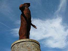
In 1960 an underground explosion at Six Bells Colliery resulted in the loss of life of 45 local miners. Fifty years later the archbishop of Canterbury Rowan Williams officiated at the launch of the Guardian mining memorial. This artistically acclaimed monument standing at 20m tall overlooks Parc Arael Griffin, the now reclaimed and landscaped former colliery site. The adjoining Ty Ebbw Fach visitor centre provides conference facilities, a restaurant and a "mining valley" experience room. Not long after the disaster the renowned artist L. S. Lowry visited the area and recorded the scene. The resultant landscape painting now hangs in the Museum of Wales in Cardiff.[9]
The coal mines remained the predominant economic emphasis until the general run down of the industry in the 1980s.
Abertillery Conurbation

Away from the town centre, the often steep sided nature of the landscape, imposes its own demands on development. Whilst this sounds limiting it has helped provide the almost amphitheatre nature of Abertillery Park, often described as one of the most attractive rugby grounds in world rugby.[10]
The street plan and housing stock flow uninterrupted from Cwmtillery in the north to Six Bells in the south, forming the town that is Abertillery. Prior to 1974 local government was provided by Abertillery Urban District Council (AUDC).[11] Its area included the small neighbouring villages of Aberbeeg, Llanhilleth and Brynithel. Historical data relating to Abertillery occasionally refers to this AUDC area meaning that it can be difficult to compare like with like. For example, the 2014 population for the wider conurbation area is around 20,000 rather than the 11,000 often quoted for Abertillery itself.
Whilst in the main the area has an older housing stock there are several developments of modern, often large homes, generally found on the outskirts of the town with views out over the surrounding area. These apart, terraced council tax band A and B properties predominate, meaning that average house prices are among the most affordable in the UK.
Local history
There are very few written historical records relating to the area possibly because today's town developed as late as the middle of the 19th century. Nevertheless, there are facts that you can use to outline important events.
- Abertillery museum has locally discovered artefacts dating as far back as the Bronze Age.
- St Illtyd's Church overlooking the town dates to the 13th century – probably with 6th century origins.[12]
- St Illtyd's Motte lies just to the south west of the church. A Norman castle mound, it was probably destroyed in 1233.
- The ruins of two more recent, probably 14th century, castles lie on private land to the northeast of St Illtyd's Church.[13]
- There are several ruined mediaeval farmhouses in the Abertillery area.
- The Local Blaenau Gwent Baptist church can trace its roots back to Tŷ Nest Llewellyn, a ruined 17th-century dwelling place often used by non-conformists to escape from the religious persecution of the times.[14]
Before the coming of major industry, Abertillery was little more than an area of scattered farms in the ancient parish of Aberystruth. In 1779 the parish minister Edmund Jones[15] described the area thus: "The valley of Tyleri ... is the most delightful. The trees ... especially the beech trees, abounding about rivers great and small, the hedges and lanes make these places exceeding pleasant and the passing by them delightful and affecting ... in these warm valleys, with the prospect of the grand high mountains about them would make very delightful habitations." In 1799 historian Arch Deacon Coxe toured the area and in writing a diary of his travels described it as "... richly wooded, and highly cultivated...we looked down with delight upon numerous valleys ... with romantic scenery". The entire population of Aberystruth parish at the turn of the 19th century was just a little over 800. It is not known what the population of Abertillery was at the time but it was probably in the very low hundreds, all of whom would have spoken Welsh only.
The area's first deep coal mine was sunk in 1843.
Formed in 1877, Abertillery Urban District Council incorporated the adjoining smaller communities of Six Bells, Cwmtillery, Brynithel, Aberbeeg and Llanhilleth. The population of this conurbation climbed to almost 40,000 in 1931 making it the second largest town in Monmouthshire.[16] The council was abolished in 1974 as part of major UK wide local government reorganisation.
Transport
The reopening of Abertillery railway station has been identified as a future development of the Ebbw Valley Railway. Regular bus services ( operated by Henley Coaches) in the area link with Llanhilleth railway station, 2 miles (3 km) away.
Education
The modern local comprehensive provides secondary education for the town and neighbouring areas. It is fed by several small schools, the most recent of which was opened in 2000. Until the 1970s the town had its own local authority run Grammar school providing education up to the age of eighteen. Tertiary education is now provided by Coleg Gwent at Ebbw Vale – opened in 2013.
Industry
There are several small and medium-sized business parks in the area offering a range of business premises. In 2014 the largest employer was Tyleri Valley Foods. Many local people commute outside the area to work.
Sport, leisure and tourism
Abertillery Town cricket club and Abertillery Blaenau Gwent RFC formed in the 1880s. Both have their playing headquarters at "the Park" one of the most picturesque sporting complexes in the UK.

The town supports two local Saturday football teams: Abertillery Bluebirds and Abertillery Excelsiors. There are numerous other sports activities running on an organized basis such as bowls, badminton, squash etc.
The surrounding landscape provides ideal hill walking opportunities and walker led groups are thriving in the area. The Borough Council provides details of local walks.
The local museum has displays showing what life was like in the area in its heyday. It even has its own "valleys" Italian café complete with original furnishings.
The very modern and well equipped Metropole theatre holds regular musical and drama events – from Blues to amateur dramatics and dance.
The critically acclaimed 20-metre-tall (66 ft) Guardian memorial is a favourite destination for visitors to South Wales and amateur photographers in particular. The visitor centre Tŷ Ebbw Fach stands nearby and provides cafe and visitor "mining valley" experience facilities.
Notable people
- For details of local people of note in the fields of sport, science, medicine, religion and art see People from Abertillery
International relations
Abertillery is twinned with:
See also
References
- ↑ "Town population 2011". Retrieved 6 November 2015.
- ↑ The Welsh Language Board (26 February 2004). "No. & Percentage Welsh speakers 3+ By Community and Age" (XLS).
- ↑ Comisiynydd y Gymraeg - Cyfrifiad 2011: canlyniadau yn ôl Cymuned. Retrieved 7 June 2014
- ↑ Remodelling and modernisation project
- ↑ Metropole Theatre
- ↑ Jubilee Square
- ↑
- ↑ "Cwmtillery Colliery". welshcoalmines.co.uk. Retrieved December 2, 2014.
- ↑
- ↑
- ↑ Abertillery Urban District Council
- ↑ St Illtyd's Church
- ↑
- ↑ Ty Nest Llewellŷn
- ↑ Rev Edmund Jones
- ↑
External links
- Abertillery Online
- BBC On This Day item about Six Bells
- Abertillery Bluebirds Football Club
- Photos of Abertillery and surrounding area on geograph.org.uk