Abel Tasman National Park
| Abel Tasman National Park | |
|---|---|
|
IUCN category II (national park) | |
 Map of New Zealand | |
| Location | Tasman District, New Zealand |
| Nearest city | Motueka |
| Coordinates | 40°50′S 172°54′E / 40.833°S 172.900°ECoordinates: 40°50′S 172°54′E / 40.833°S 172.900°E |
| Area | 225 square kilometres (87 sq mi) |
| Established | 1942[1] |
| Governing body | Department of Conservation |
Abel Tasman National Park is a New Zealand national park located between Golden Bay and Tasman Bay at the north end of the South Island. It is named after Abel Tasman, who in 1642 became the first European explorer to sight New Zealand and who anchored nearby in Golden Bay.
History
The park was founded in 1942, largely through the efforts of ornithologist and author Pérrine Moncrieff to have land reserved for the purpose. Moncrieff served on the park board from 1943 to 1974.[2]
The park was opened on the 18 December 1942 to mark the 300th anniversary of Abel Tasman's visit.[3] Those in attendance at the opening ceremony at Tarakohe included Charles van der Plas, as personal representative of the Netherlands' Queen, Wilhelmina. The Queen was made Patron of the park.[4]
The idea for the park had been under consideration since June 1938. The Crown set aside 15,225 hectares (37,622 acres), comprising 8,900 hectares (21,900 acres) of proposed state forest, 5,809 hectares (14,354 acres) of Crown land and 554 hectares (1,368 acres) of other reserve land for the national park.[5] The Golden Bay Cement Company donated the land where the memorial plaque was sited.[3] The area's primary historic interest was the visit of Tasman in 1642, D'Uville in 1827, and the New Zealand Company barques Whitby and Will Watch, and brig Arrow in 1841. The site was also of significant botanical interest.[5]
By 1946 the park had reached 15,534 hectares (38,386 acres) in area with additional land purchases. A further 844 hectares (2,085 acres) at Totaranui, formerly owned by William Gibbs, was acquired from J S Campbell in 1949 and added to the park.[6] About 6,100 hectares (15,000 acres) have been added since. In 2008 an extra 7.9 km2 (790 ha; 3.1 sq mi), including the formerly private land known as Hadfields Clearing, were added to the park.[7]
Description

Covering an area of 225.3 km2 (87.0 sq mi; 55,700 acres), the park is the smallest of New Zealand's national parks.[8] It consists of forested, hilly country to the north of the valleys of the Takaka and Riwaka Rivers, and is bounded to the north by the waters of Golden Bay and Tasman Bay. It contains some of the islands off the coast including the Tata Islands in Golden Bay, and Tonga Island, Adele Island, and Fisherman Island in Tasman Bay.[1]
The park does not extend beyond Mean High Water Mark on the adjacent coast. Between Mean High Water and Mean Low Water Springs, the beaches are gazetted as a Scenic Reserve, covering 7.74 km2 (2.99 sq mi) in total. The Tonga Island Marine Reserve adjoins part of the park.
Some of the birds that frequent the park are petrels, shags, penguins, gulls, terns, and herons. Possums, wild pigs, deer, and goats also frequent the park.[1]
The Abel Tasman Coast Track is a popular tramping track that follows the coastline and is one of the Department of Conservation's Great Walks; the Abel Tasman Inland Track is less frequented. Kayaking, camping and sightseeing are other activities.
Access to the park is usually via the small settlement of Marahau.[9] The nearest large town is Motueka, 20 kilometres (12 mi) to the south.
Management
The Department of Conservation administers the National Park. The Scenic Reserve is administered by the Tasman District Council Chief Executive and Department of Conservation’s Nelson/ Marlborough Conservator.
Activities in adjoining coastal waters are Tasman District Council's responsibility. These areas operate under separate regulations.
-
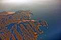
Abel Tasman National Park from the air
-
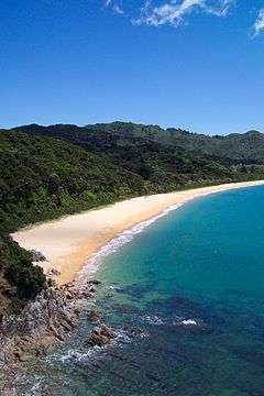
Totaranui is a 1 km long beach and the location of a large campsite.
-
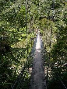
Swingbridge on the track
Project Janszoon
In 2012 Project Janszoon, a privately funded trust, was set up to restore the park's ecosystems. The trust takes its name from Tasman's middle name Janszoon. It is aiming to complete the restoration in time for the 400th anniversary of Tasman's visit and the park's 100th anniversary in 2042.
The Department of Conservation and Project Janszoon developed a free virtual visitor centre for downloading to smartphones or tablets. The application provides information about the Park's history, its flora and fauna, points of interest, weather, walking tracks, and tides.[10] This virtual visitor centre is free of charge and can be found through the App Store or Google Play Store.
See also
- National parks of New Zealand
- Forest parks of New Zealand
- Regional parks of New Zealand
- Protected areas of New Zealand
- Conservation in New Zealand
References
- 1 2 3 Hoiberg, Dale H., ed. (2010). "Abel Tasman National Park". Encyclopedia Britannica. I: A-ak Bayes (15th ed.). Chicago, IL: Encyclopedia Britannica Inc. p. 25. ISBN 978-1-59339-837-8.
- ↑ http://www.teara.govt.nz/en/biographies/4m57/moncrieff-perrine
- 1 2 Historic Event, Evening Post, Wellington, Volume CXXXIV, Issue 127, 25 November 1942, Page 3
- ↑ Tasman Tercentenary, Evening Post, Volume CXXXIV, Issue 144, 15 December 1942, Page 4
- 1 2 Memory of Tasman A new National Park, Evening Post, Volume CXXXIV, Issue 147, 18 December 1942, Page 4
- ↑ Appendix to the Journals of the House of Representatives, 1949 Session I, C-10 Page 4
- ↑ "National Parks gain ground". press release. New Zealand Government. 20 March 2008. Retrieved 26 March 2008.
- ↑ "Abel Tasman National Park". Department of Conservation. Retrieved 6 August 2014.
- ↑ http://www.abeltasman.net.nz/
- ↑ "janszoon.org". Retrieved 2015-02-22.
External links
| Wikimedia Commons has media related to Abel Tasman National Park. |
- Information about the park, NZ Department of Conservation
![]() Abel Tasman National Park travel guide from Wikivoyage
Abel Tasman National Park travel guide from Wikivoyage