La Cambre Abbey
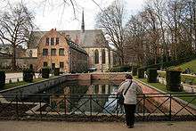
The Abbey of La Cambre or Ter Kameren Abbey (French: Abbaye de La Cambre, Dutch: Abdij Ter Kameren) is a former Cistercian abbey in Ixelles, Brussels, Belgium. It is located in the Maelbeek valley between the Bois de la Cambre and the Ixelles Ponds. The abbey church is a catholic parish of the Archdiocese of Malines-Brussels and home to a community of Norbertine canons while other parts of the monastery house the headquarters of the Belgian National Geographic Institute and La Cambre, a prestigious visual arts school.

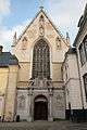
The abbey was founded about 1196. It was suppressed at the French Revolution. Today's buildings are from the 18th century. The simple abbey church houses Albert Bouts' early 16th-century The Mocking of Christ.
Architecture
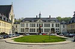
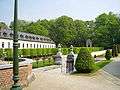
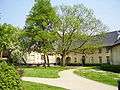
The cloister adjoins the abbey church and the refectory. The 18th-century abbesses' residence, with its cour d'honneur and formal gardens, has preserved the presbytery and the stables and other dependencies.

History
The abbey was founded about 1196, by its patroness Gisèle, with the support of the monastic community of the abbey of Villers, following the Cistercian rule. Henry I, Duke of Brabant donated the Étangs d'Ixelles, a water mill, and the domaine of the monastery. The Abbaye de la Chambre de Notre-Dame, hence La Cambre, remained under the spiritual guidance of Villers, one of the most important Cistercian communities.
Saint Boniface of Brussels (1182–1260), a native of Ixelles, canon of Sainte-Gudule (future cathedral of Brussels), who taught theology at the University of Paris and was made bishop of Lausanne (1231), lived eighteen years in the abbey and is interred in the church. The mystic leper saint Alix lived in the community at the same epoch.
During the numerous wars of the 16th and 17th centuries, the abbey was largely destroyed, but it was rebuilt in the 18th century, in the French form it largely retains.
The terraced garden and formal clipped bosquets were restored in the 18th-century manner starting in 1924.
Gallery
Coordinates: 50°49′08″N 4°22′27″E / 50.81889°N 4.37417°E