Abbey Farmhouse, Montacute
| Abbey Farmhouse | |
|---|---|
 | |
| Location | Montacute, Somerset, England |
| Coordinates | 50°56′54″N 2°43′10″W / 50.94833°N 2.71944°WCoordinates: 50°56′54″N 2°43′10″W / 50.94833°N 2.71944°W |
| Built | 16th century |
Listed Building – Grade I | |
| Designated | 19 April 1961[1] |
| Reference no. | 263546 |
 Location of Abbey Farmhouse in Somerset | |
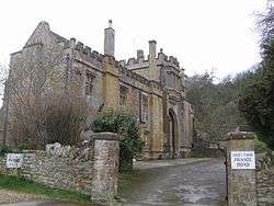
Abbey Farmhouse is a detached house in Montacute, Somerset, England, which incorporates the gateway of the medieval Montacute Priory. It was built in the 16th century and has been designated as a Grade I listed building.[1]
After the dissolution of the monasteries the property became a farmhouse, but by 1633 it was 'almost desolate'. By 1782 it was a revitalised farm, remaining part of the Phelips estate until 1918.[1][2]
There are 2.5 acres (1.0 ha) of walled gardens, which have been laid out since 1963.[3]
A long distance public footpath, the Monarch's Way runs along the course of a Roman (or earlier) trackway immediately in front of the building. This path leads to Ham Hill Country Park via fields and woodland
See also
References
- 1 2 3 "Abbey Farmhouse". Images of England. English Heritage. Retrieved 2009-07-11.
- ↑ "Parishes: Montacute". A History of the County of Somerset: Volume 3 (1974), pp. 210-224. British History Online. Retrieved 20 November 2010.
- ↑ "Abbey Farm". NGS gardens open for charity. Retrieved 20 November 2010.
This article is issued from Wikipedia - version of the 6/7/2015. The text is available under the Creative Commons Attribution/Share Alike but additional terms may apply for the media files.