A643 road
| |
|---|---|
|
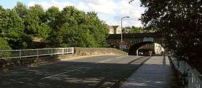
A643 crossing Rastrick Bridge | |
| Route information | |
| Length: | 18 mi (29 km) |
| Major junctions | |
| East end: |
Leeds 53°47′21″N 1°34′02″W / 53.7892°N 1.5671°W |
|
[[Image:Motorway Left.svg|[ |x30px|link=]] | |
| West end: |
Outlane 53°39′36″N 1°51′33″W / 53.6599°N 1.8592°W |
| Location | |
| Primary destinations: |
Leeds Brighouse Huddersfield |
| Road network | |

The A643 is a main road in West Yorkshire, England.
It starts at the Armley Gyratory and ends at junction 23 of the M62 Motorway (Mount Roundabout, Outlane, Huddersfield) and is approximately 18 miles (29 km) long.
The road goes through Morley, Birstall, Gomersal, Cleckheaton, Brighouse, Rastrick to the north of Huddersfield (Ainley Top and Mount).

The A643 Ingram Distributor in Leeds
The Leeds United AFC football stadium is named after the road part of the A643 that passes it, Elland Road. This road is so called because the A643 originally ended in town of Elland near Halifax.
External links
A roads in Zone 6 of the Great Britain road numbering scheme | ||
|---|---|---|
Coordinates: 53°43′20″N 1°43′47″W / 53.7221°N 1.7296°W
This article is issued from Wikipedia - version of the 2/4/2013. The text is available under the Creative Commons Attribution/Share Alike but additional terms may apply for the media files.